by George Fery
Hidden in the verdant hills of the Sierra Chapaneca in the beautiful State of Chiapas, southern Mexico, is the ancient capital of the B’aakal kingdom. The name of the city then was Lakam-ha’ in Maya-Yucatec language. The town is today called by its Spanish name, Palenque.
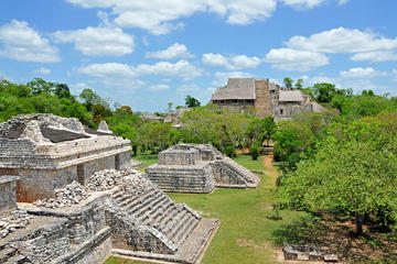
Remains of impressive Maya temple-pyramids and palaces abound all over Mesoamerica. Many archaeological sites overwhelm the visitor by their monumental architecture. Few are as remarkable as Palenque for its fine palaces, temples and architecture. The layout of this UNESCO World Heritage Site, and its location within a jungle clad mountain range, is replete with springs, streams and falls, overlooking the plains of Tabasco.
The 1998-2000 PMP-Palenque Mapping Project under Mexican INAH-Instituto de Antropologia e Historia management, and FAMSI-Foundation for the Advancement of Mesoamerican Studies (famsi.org), led by Dr. Edwin L. Barnhart, recorded and mapped 1481 structures at Palenque. The PMP covered 0.850Mi2/2.2Km2 of the city jungle shrouded plateau. The area referred to as “Central Palenque” open to visitors, account for less than a hundred buildings and structures. All others are still covered under a dense tropical rain forest. At its height during the Classic, the urban population may have reached 7500-8000 souls.
 Early morning, when nature awakes and the mist from the jungle slowly lifts, the welcoming calls of howler monkey greet visitors, together with shrieking tropical birds. Palenque’s ancient name probably came from the cluster of small rivers, that come out from the upper slopes of the mountain that overlook the site. The ancient name Lakam-ha’ translate as “Big Waters” for its numerous falls through ravines and over great natural stair-steps. The Yemal K’uk’ Lakam Wiz or “Great Mountain of the Descending Quetzal”, stands over the great city of Classic times (250-950).
A Great Maya Lord
Shrouded in the mist of time one wonders, who lived here? At its height from the end of the 5th to mid-9th century, it was an important metropolis, and a major player in political and trade in the region. Its greatest achievement however, was in architecture and the arts. The 7th century saw the birth and death of one of the greatest Mid-Classic Lord in Maya history, K’inich’ Janahab’ Pakal.II (603-683).
By all accounts Pakal was the greatest Lord of the B’aakal kingdom, as it was then called. His title, like lords before and after him, K’uhul B’aakal Ajaw translate as “Sacred Lord of the B’aakal Kingdom”; it underlines the commanding secular and religious functions of Maya lords. His 68 years reign (615-683), was one of the longest in Maya history. Pakal inherited the kingdom at the young age of 12 but was sacred Lord at 23. During the interregnum, his mother Sak K’uk’ Ajaw governed as regent, not as a Lord of the realm.
Pakal’s wife, Ix Tzak B’u Ajaw was from Ux Te Kuh’, the northwest city where his family took refuge, when Palenque was burned by the Kan Kingdom proxies, twice, in 519 and 611. She is buried next to her husband mausoleum, The Temple of the Inscriptions. Her resting place is Temple XIII, referred to as the Temple of the Red Queen, for the large amount of hematite, a red pigment iron oxide, found in her sarcophagus.
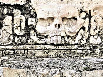 Temple.XIII and Temple.XII, known by its enigmatic name, Temple of the Skull, are adjacent to each other on an east-west line. They are separated by Temple.XIIA not yet fully excavated. The Temple of the Skull is named after the skull shown at the base of its west pier. It is the skull of a rabbit, whose shape is seen on the full moon. The rabbit representation on the moon is common in the New World and Asia. The skull on Temple.XII is that of Goddess.O, the Aged Goddess of the Falling Moon, to whom the temple was probably dedicated.
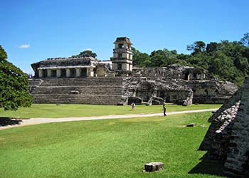
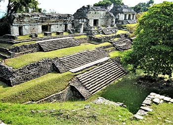
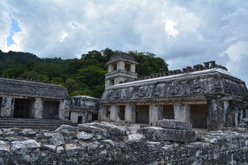
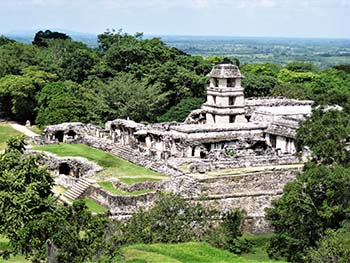 The Palace, open to visitors, is built on a massive irregular quadrangle; it was a ceremonial and administrative building. Large stairways on three sides allowed access to the vaulted halls that ringed the quadrangle. The south side stairway was ceremonial, while the north side was utilitarian. The complex is made of a complicated system of vaulted buildings, lengthy halls and three courtyards.
The PMP project discovered a palace complex west of central Palenque, that is still under the jungle canopy, and is significantly larger than the Palace. Of note are the names assigned to buildings by archaeologists, that do not always reflect their true function at the time; “temple” and “palace” on the record are but terms of convenience.
In the middle of the Palace complex, the Tower’s third floor holds an altar built of limestone mixed with a large quantity of seashells from the Pacific. The altar may have been dedicated to ceremonies linked to the legendary Primordial Seas. The belief may have been supported by numerous marine fossils found in the limestone of the mountain range.
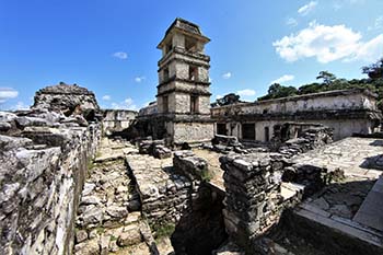 On the Palace east side runs the Otolum River, its banks walled up as a canal, a key part of the important and elaborate, water management system of the city. Bathrooms were found below the plaza level. The Palace was mainly used for administrative and ceremonial purposes, for the ruler, members of the nobility with bureaucratic functions, scribes, high priests and formal state receptions of ambassadors or important visitors.
People did not reside in the Palace; the tropical humidity and thick stone walls were not conducive to ventilation. They lived outside in fine traditional wattle and daub structures set on stones with a short vertical wall. Thanks to their semi-open construction, it allowed for ventilation to pass through, a plus for comfort in a tropical environment, especially in rainy season. The residential area was located close by, east of the Palace, beyond the Otolum river canal.
The Rise and Fall of History
The history of the city is tumultuous with frequent wars, as well as great and not so great Lords at its head. At the death of her father, Ix Yohl Ik’nal Ajaw (reigned 583-604), was the only woman elevated to K’uhul B’aakal Ajaw or Sacred Lord of the B’aakal kingdom. Her reign was plagued by hostility from within and without. Regional antagonism was fueled by two enemies for different but complementary reasons. The first was Tortuguero, a city located in the northern plains of Tabasco. Leaders of that city claimed the title of K’uhul B’aakal Ajaw that Palenque rightly demanded as its historical right. A deep-seated enmity endured that fed their antagonism for years.
The second is that of Calakmul, the powerful K’an kingdom to the northeast in Yucatan that fueled both cities’ antagonism for its own benefit: control of trade routes and that of the Usumacinta river, a major waterway. Its other proxy Tonina was only 41Mi/80Km distant from Palenque, in today’s Ocosingo valley. This enmity will remain a thorn in Palenque’s side through murderous wars, up to its collapse in 850-900.
There may have been another reason for this lasting enmity with the powerful K’an kingdom. Palenque traded and probably had political contacts, with the powerful metropolis of central Mexico, Teotihuacan. Calakmul then may have perceived Palenque as a Mexican proxy in the Maya heartland, which would explain such a long-lasting and violent antagonism.
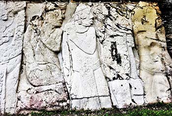 In 659 Pakal got his revenge against the K’an kingdom, as shown in the West Court of the Palace. The carved limestone slabs show six sahals (state officials) of Santa Elena and Pomona, other proxies of the Great Jaguar militaristic totem, Calakmul. They are shown bound and ready for execution, facing the carved steps across the courtyard that recount Palenque’s defeats and burning in 599 and 611.
The antagonism with Tonina in particular, will last to the end of Palenque’s dynasties. K’inich K’an Joy Chitam, Pakal 66 years old second son was captured in battle in 711 and held prisoner for seven years. Unlikely, he was freed by Tonina, but the reason for his release and the terms attached to his freedom, are unknown. After his release, he remained Lord of Palenque for another ten years, before his death.
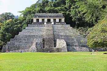 The Temple of the Inscriptions, is Pakal’s last resting place; truly the most important and renowned sanctuary ever built in the Americas. Its name comes from the three large hieroglyphic panels found on the walls of the sanctuary, in the temple. In the past, it was known as the “Temple of the Laws” because of the glyphs covered limestone panels. They narrate Pakal’s achievements and his place in the context of eternity. The temple-pyramid also had an exceptional “roof crest”, now lost to time. The building, like all major buildings in the city, was covered with stucco and painted red, from its base to the roof. For visitors it must have been an impressive sight to behold.
The eight-steps funerary pyramid, the B’olon Eht Naah as it was called then, was planned by Pakal. Its foundations were built and the sarcophagus and its slab set, about five years before Pakal’s death (683). It was completed by his elder son and heir K’inich K’an Bahlam’ (635-702). The temple at the top of the pyramid complete the mythological nine levels of Xibalba, the underworld.
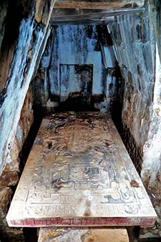 The grandeur of the crypt, 82 feet down in the pyramid, with its 20 tons massive sarcophagus and 5 tons slab, both with remarkable engravings, are truly unique. The crypt is located a mere six feet below the level of the main plaza. They were built and set before the pyramid was erected. On the sarcophagus’ four sides are engraved Pakal ancestors sprouting from fruiting trees, acknowledgement to ancestor worship. The renowned finely carved sarcophagus’ slab relates Pakal mythical journey after death through the underworld, and his rebirth as Hunal Ye’ the maize god.
Nine life size stucco figures are on the walls surrounding the sarcophagus; eight men and one woman, Lady Ol Nal. They are assumed to have been Pakal’s guardians, warding off malevolent forces when his body was carried down the steps of the pyramid. The “Nine Lords of the Night” are now standing guard for eternity.
Five persons, the so called “companions”, were sacrificed to attend and serve the Lord in the afterlife, a customary practice of ancient cultures for significant ranking individuals. They were identified as two males and a female in their late teens or early twenties (the two others could not be sexed, due to the remains deterioration). They were buried in a shallow stone cavity behind the now open massive triangular door, that sealed the entrance to the crypt in 690.
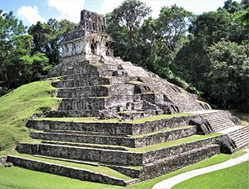 The Cross Group complex, is at the heart of the ancient city, and its temple-pyramids: the Temple of the Cross, Temple of the Foliated Cross and Temple of the Sun are accessible, but one cannot get into their sanctuaries. The view of central Palenque from atop the Temple of the Cross is spectacular. They are collectively referred to as Palenque’s Divine Triad; and represent the tri-partite conception of the world space and royal power.
Each temple is the home of a god named by Henrich Berlin in 1963 as God.I, God.II and God.III. They were born in Matwill, the Maya mythical world a few days apart; Berlin assumed that they may have been triplets. In each temple is a large finely carved limestone panel, that relate the story of Pakal’s eldest son and heir, K’inich’ K’an Bahlam’ accession to the throne in 684. He is shown with his father, in the act transferring lordship powers to himself, together with dedications to the gods of the Divine Triad.
At the entrance of the Cross Group complex, but not a part of it, one may climb up the steps to Temple.XIV to see its remarkable limestone carved panel on the back wall of the sanctuary. K’inich’ K’an Bahlam’ is shown receiving the K’awiil’ scepter of lordship from his mother Lady Tz’ak-b’u Ajaw, dressed in the garments of the Moon Goddess.
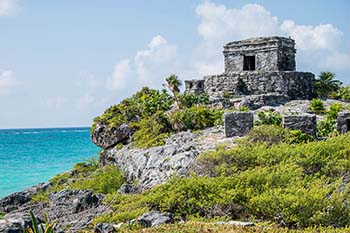
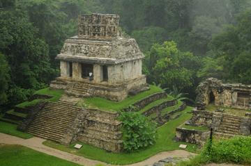
Standing by itself a few steps away from the North Group and the Ball Court, the Temple of the Count (pictured at top) is named for an exceptional character, the French archeologist Jean-Frédérick de Waldeck. For two years in 1872, while researching and writing about Palenque, he camped in the temple on top of the pyramid. He recorded important carvings on stone and stucco now eroded or mostly unreadable. His drawings of carved panels and their interpretations may be questionable, but he did record the ancient art of the city that may otherwise have been lost forever.
 The North Group, so called because it is located north of the Palace, is of interest for Palenque’s interaction with Teotihuacan. Evidence found at the base of Temple.V of a stucco frieze in the sub-structure shows the figure of a man whose dress and adornment leave no doubt as to an Early Period contact with the great metropolis of central Mexico. The goggled eye warrior, armed with a spear thrower or atlatl in his left hand, is clearly Mexican and relates to Tlaloc, Aztec god of rain, thunder and war.
The numerous streams and falls that cascade from the Great Mountain of the Descending Quetzal, create numerous quiet pools. The widest are the ones near the bottom of the mountain; they are referred as the Queen’s Baths.
The tropical environment provided an abundance of water and forest products, from fruit trees to soft and hard wood. Wildlife, from jaguar, wild turkeys, and forest deer to scarlet macaws, was a bounty. This exceptionally luxurious environment enhances the elegance of the multiple falls and pools, a beautiful experience at the end of a day’s visit of this great Maya metropolis.

 If You Go:

How to Get There – Recommended
Direct flights Mexico City Palenque are available. Air service also available to Villahermosa, 83miles/134Kms northeast of Palenque.
Bus service are available between cities and their airports.
On GPS it is: 17d 29’ 52”N, 92d 03’ 02”W.
For those driving, from Villahermosa or Ciudad del Carmen, use Highway MX186 to the small town of Catazaja, then to a turnoff on Highway MX199 to Palenque (toll road); transit time may be 2.5 hours.
Palenque Mayan Ruins, Misol-Ha and Agua Azul Waterfalls Full Day Tour from Palenque
Excellent international class hotels are available downtown, as well as on the road to the archaeological zone, together with fine restaurants, serving both international foods and Mexican recipes from Chiapas.
The archaeological site is 4miles/8Kms from downtown Palenque.
The site opens from 8am to 4:30pm; the entrance fee is currently $4.50/65Pesos; parking is $1.75/35Pesos.
At the entrance to the site are guides, available for a fee, speaking English and other language. There are also small stalls selling bottled water and snacks.
Recommended: hat, sunscreen, bug spray, comfortable walking shoes, bottled water, pocket poncho, Imodium.
Where access on structures is permitted, it is strongly recommended to use great caution while climbing up and, especially, going down the stairs.
For safety and conservation purposes, access to the following structures is either limited or prohibited: Temple of the Inscriptions, the Tower in the Palace, Temple of the Count, and the North Group. In the Cross Group complex, where one can climb the stairs to the temples, but access into the sanctuaries is prohibited; as are areas under archaeological investigation or maintenance.
Palenque Archaelogical Site, Agua Azul and Misolha Waterfalls Combo Tour
Recommended: not to leave the site without a visit to the museum and its remarkable collection of artifacts, especially the ceramic censers. It is located at the bottom of the hill before the entrance. Follow the trail and steps down to the Queen’s Baths area. At the bottom turn right at the main road, the museum will be a couple of hundred feet at left.
Details on the history, art and architecture of Palenque, are available in “Long-Form Articles” at georgefery.com.
Notes
Mesoamerica is a geographical and cultural area that extends from southern Mexico to Belize, Guatemala, Honduras, El Salvador, Nicaragua and northern Costa Rica.
Years in text above are AD/CE.
Recommended reading: Palenque: Eternal City of the Maya by David and George Stuart.
About the author:

Freelance writer, researcher, and photographer, Georges Fery (georgefery.com) addresses topics, from history, culture, and beliefs to daily living of ancient and today’s indigenous communities of the Americas. His articles are published online in the U.S. at travelthruhistory.com, popular-archaeology.com, and ancient-origins.net, as well as in the quarterly magazine Ancient American (ancientamerican.com). In the U.K. his articles are found in mexicolore.co.uk.
The author is a fellow of the Institute of Maya Studies instituteofmayastudies.org Miami, FL, and The Royal Geographical Society, London, U.K. rgs.org. As well as a member in good standing of the Maya Exploration Center, Austin, TX mayaexploration.org, the Archaeological Institute of America, Boston, MA archaeological.org, NFAA-Non Fiction Authors Association nonfictionauthrosassociation.com, and the National Museum of the American Indian, Washington, DC. americanindian.si.edu.
Photographs:
All photos are ©georgefery.com
- Temple of the Count
- Central Palenque
- Temple of the Skull
- The Palace
- The Tower
- Faces of Defeat
- Temple of the Inscriptions
- The Crypt
- Temple of the Cross
- The North Group