Africa
by Ian Packham
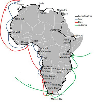
I was on the Kenyan coast at Malindi, having followed the African coast west from Tangier, Morocco’s seedy port of entrance for so many Europeans. I was attempting to complete the first solo and unsupported overland circumnavigation of the continent by public transport, an expedition I had christened Encircle Africa. But all the while, through eight months of travel from Tangier to Malindi, I was aware others had been there before me. Vasco da Gama reached Malindi in Kenya after nine months in 1498. He was on his way to the Malabar Coast of India. I was on my way back to Tangier, through East Africa and across the Mediterranean coast. For much of his route he followed passages determined by the earlier explorers Diogo Cao and Bartolomeu Dias. But while Dias returned home to a feeling of failure, da Gama returned a hero, celebrated like the Apollo 11 astronauts on their return from the moon.
The three Portuguese explorers I would continually cross paths with may have been the most visible, having positioned padrãos (navigational pillars) around three-quarters of the African continent, but they certainly weren’t the first. It is believed the Phoenicians made it so far, in the sixth century BC, as to be able to provide the first known description of the gorilla. Chinese ships rounded Cape Point from the east in 1421, decades before the Portuguese would do the same from the west. And Kenya’s coastal civilizations had been in contact with other continents for centuries. But it was Europe’s Portuguese explorers that opened up the continent for all that was to come, including my own personal exploration.
 The padrãos had several intentions, as did the voyages around the African continent themselves. Portugal, surrounded by hostile kingdoms, turned to the sea to find a new route to India’s spice trade that eliminated greedy middle men. The padrãos not only acted as navigational aids, but proclaimed the land around them as Christian, and belonging to the Kingdom of Portugal. They were also a handy source of ballast, generally only positioned on a voyage’s homeward journey. The carved inscription on the Cape Cross padrão reads: “In the year…1485 after the birth of Christ, the most excellent and serene king Dom John II of Portugal ordered this land to be discovered and this padrão to be placed by Diogo Cao”.Namibia’s Cape Cross was Cao’s journeys end. The next 15 years would see countrymen Bartolomeu Dias and Vasco da Gama forge a sea route to India’s Malabar Coast. Each explorer was dependent upon the discoveries of those who had gone before and the padrãos they had positioned.
My first chance to cross paths with these explorers came after only two weeks, in Western Sahara, at the town of Boujdour. I missed any chance of even a glimpse of the town Cao had visited, since my only way south from Laayoune was a direct overnight coach to Dakhla. It would become a theme of Encircle Africa. Our paths didn’t cross again until Cap Vert, Senegal, the most westerly point of the African mainland.
Cao was able to sail straight to Elmina, Ghana from anchor at Cap Vert. I had had to struggle through the ever improving but often muddy dirt roads of Guinea, Sierra Leone, and Liberia just after the rains.
 I didn’t get close enough to feel their influence until reaching Soyo on Angola’s northern border, the southern bank of the River Congo, four months after beginning. It took Cao about the same length of time by sail. Even then I was unable to find the fragmentary remains of his padrão which are said to exist.
Cao and Dias made several different forays into Angola, with Cao stopping at Benguela and Cape Santa Maria, and Dias further south at Tombua. Yet the closest I came to the explorers in Angola was Diogo Cao Road in the heart of colonial Benguela. I reached the end of Cao’s expeditionary advances without getting any closer to them.
I relaxed knowing that for 500 years people like me had in some way or other been following the African coast. Whether it was Boujdour in Western Sahara or Benguela in Angola, people with far less knowledge of their environment had returned home. Those explorers used tiny ships called caravels. I didn’t have my own transport, but I had maps which the explorers didn’t, and a cell phone. We were both dependent on the locals to provide food and water.
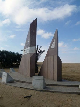
 Dias used Cao’s discoveries to continue, taking anchor 75 miles further south at Walvis Bay, a town still dependent on ships anchoring today. On its outskirts, monumental stylized rigged ships celebrate the town’s earlier European visitor.
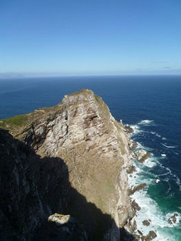
Dias and his crew became the first Europeans to round the southern Capes. A beach at Cape Point, facing south towards Antarctica celebrates this fact, being named Dias beach. It’s a beautiful, blustery, cold place even now. For me it marked six months of travel, and Encircle Africa’s halfway point. Dias was reaching his end.
He landed at Mossel Bay to take on fresh water, on February 3 1488. The town is home to a replica caravel inside the Dias Museum. Dias was eager to continue his voyage, but his crew was not. His three caravels ended their outward journey at Kwaaihoek on March 14.
It was perhaps Dias of the three explorers that knew Africa best. Ten years on, Vasco Da Gama didn’t make landfall on the African continent until Saint Helena Bay, now a northern suburb of Cape Town, where a simple granite monument to his achievement can be seen.
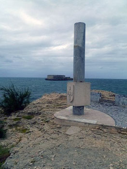 From Mossel Bay da Gama faced unknown seas, passing Dias’ endpoint on December 16 1497. It was coming up to Christmas, so the coast da Gama spotted on his left hand side was named Natal (birth). His four caravels continued up the East coast of Africa eventually reaching Mozambique Island. Here on the island’s eastern end, facing a small, later Portuguese fort, I encountered the remains of his padrão. This was the closest I had come so far to one of the original navigational aids.
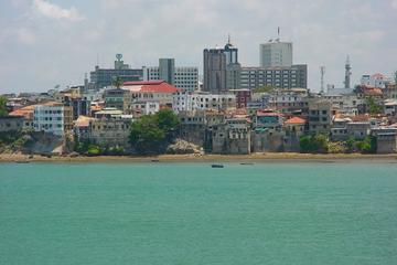
Da Gama went on to reach Mombasa in Kenya, a town hostile to his intentions that forced him further north to Malindi. There, after much searching, I found a tourist office hidden around the back of an ugly building complex. I tentatively asked, knowing my success in locating signs of the explorers so far has not been great, if they knew about the padrão placed in the town by da Gama. There were baffled looks as the three staff members conversed. “You mean the pillar?” one of them suggested.
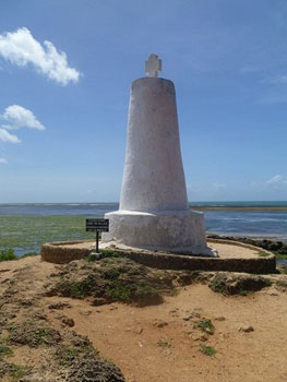 My search for the Portuguese explorers was finally over. I took a three-wheeled tuktuk to the padrão. The intervening years between me and da Gama had not been kind to it. Instead of the slim column of Lisbon limestone, it had been variously altered so it now resembled a giant white traffic cone topped with a Greek cross. Yet there it still stands on a rocky outcrop. One of the only original Portuguese padrãos I had been able to find during my own exploration of Africa 500 years on. From here da Gama went across the ocean to India. His mission complete, he returned home to report his successes to the king of Portugal. I still had to cross to Egypt, and follow the Mediterranean back to Tangier to Encircle Africa.
Mombasa Full-Day Guided City Tour
If You Go:
♦ See the map for details of the original sites of padrãos. A padrão from Cao’s explorations can now be viewed at the museum of the Lisbon Geographical Society, Portugal. The Cape Cross padrão is housed in the Deutsches Historisches Museum (Zeughaus), Berlin, Germany. Dias’ Kwaaihoek padrão de Sao Gregorio is to be found in the library foyer of the University of Witwatersand, Johannesburg, South Africa. These padrãos have been replaced by replicas at their original sites.
♦ The Dias Museum, Mossel Bay, South Africa also houses an aquarium, shell museum, Dias statue and the post office tree dating back to 1501. The museum complex is open daily except Christmas Day and Good Friday. There is an additional cost to enter the replica caravel inside the museum.
♦ The closest International airports to Malindi, Kenya are located in Nairobi and Mombasa. Several airlines provide flights from European and North American cities. Kenya Airways (a division of KLM) is the national carrier. Malindi is easily reachable by road from both cities.
Overnight Shark Cage Diving Excursion for Small Groups in Mossel Bay
About the author:
Ian is a biomedical scientist turned traveler. He is very much a ‘normal guy’ with no specialist expedition training. Encircle Africa was his first expedition. A member of the Royal Geographical Society, London, he enjoys off-beat off-season travel, preferably by public transport. He is still in the process of writing scientific articles, as well as fiction and non-fiction pieces. He aims to build on his current travels to develop a career in writing. Website: www.encircleafrica.org
All photographs copyright Ian M. Packham:
Map of my Encircle Africa route, and the routes of Cao (his second voyage), Dias and da Gama, depicting padrão sites.
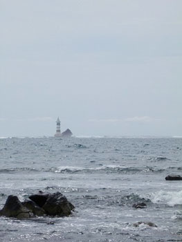
Pointe des Almides, Cap Vert, Senegal. The most westerly point of continental Africa.
Dias entered Walvis Bay, Namibia on December 8 1487. A monument on the outskirts of the town marks his visit.
Cape Point, South Africa. Dias was the first European to round Africa’s southern capes.
The remains of da Gama’s padrão, Mozambique Island, Mozambique.
Da Gama’s padrão, Malindi, Kenya.
