by Bill Arnott
A small plane hauled me north, toward Haida Gwaii – prehistoric land, old growth rainforest and Haida First Nations. It was a departure from the Viking trek I’d been on for four years, in the wake of Scandinavian voyagers. I’d just finished a Norse-Britain excursion, from the Hebrides to Lindisfarne and my dad’s dad’s hometown of Dunfermline, Scotland. Like research, my travel was following hunches and side-streets, a voyage as pointedly vague as every explorer.
I exited the little plane with a handful of locals and wanderers, gathering packs and duffels. A bald eagle circled, low, directly overhead. At a sculpture park near my home it states, “When you see an eagle you know this is a special place.” And I realized I didn’t want to find my accommodation. Not yet. There was too much to see.
From Masset I drove south to Port Clements, home of The Golden Spruce. The Spruce is an anomaly, a genetic oddity that makes albinos seem common – a three-hundred-year-old tree with needles entirely gold in colour, in a forest on Graham Island. If you’ve read The Golden Spruce, you know the story. It was cut down by a protester for reasons too complex, convoluted, to comprehend. Killing makes sense to killers. It was felled with precision, into the Yakoun River.

From the car I walked a footpath through towering evergreens – sentient sentinels, until I saw The Spruce, now on its side, spindly and bare, the colour of bones – a corpse lying in the river. This was a sacred tree. To everyone. Even the man who brought it down.
With a blessing a piece of the trunk, still living, was cut by a native, Elders and Chiefs presiding. And this modest slab of spruce, this part of the land, was passed to a luthier, a gifted Canadian artisan who fashioned the wood into a guitar, an instrument known as Voyageur. The Voyageur guitar crossed the country, the ambitious project of CBC’s Jowi Taylor. It encapsulates Canada – a guitar of and for the people. Six String Nation is its story. Imagine a small piece of furniture constructed of generations of heirlooms from every family. Now imagine you pass that around and play it, sing to it – add your stamp to the whole. When Jowi passed Voyageur to me to play on a little theatre stage on Vancouver Island, I felt pride and privilege beyond measure. One of those things bigger than any or all of us.
I took a picture of the Spruce and a glow appeared in the photo I didn’t or couldn’t see in person, and I recalled the notion of pictures capturing souls. Leaving the forest I noticed a small sign I hadn’t previously seen. “Do not look back,” it reads, “There is much more to see, feel and love.” Leave everything behind. Your life lies ahead. I read this again, slowly. Truth is, under the guise of research, I’d fled here in an attempt to process my father’s passing, which had just happened, rather tragically. And here, in the forest, ensconced in spirituality, this oddly comforting sign held me. I felt lightened, burdens dissolving – the result of letting go. It was a feeling, ironically, I longed to hold on to.
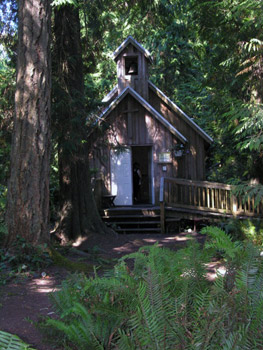
I drove a short distance on active logging road, then from gravel to winding asphalt with a centre-line – the Yellowhead Highway that leaps from the BC mainland to these islands. CBC radio – the only station – came and went as I drove. In Port Clements, I stopped at Millennium Park and the Golden Spruce Trail at Saint Mark’s church. The Golden Spruce offspring lives here. A sapling, seeded from the original, grows in a small fenced enclosure. It’s squat and scrawny, and a large feather had fallen beside it – black with downy white – a dreamy vignette, heavy with optimism. A glimpse of healing.

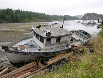
Driving south I stopped at Balance Rock – a gravity-defying hunk of basalt shaped like a monstrous rugby ball on its side, sitting improbably on a small and natural Precambrian plinth. I hiked through bushes and grazed on wild strawberries and huckleberries. Blacktail deer crossed the road, indifferent to the occasional vehicle, and ravens flew by with a whoosh of wings. I carried on through Tlell to Skidegate, where the MV Kwuna ferried me to Alliford Bay on Moresby Island, and I drove to Sandspit with two new passengers – hitchhikers from the ferry. Dropping a bag in a hostel-lodge I strolled to the pub where everyone ate halibut and chips and drank Lucky lager. Back in my room, with open window I drifted off to the warbling chirp of bald eagles, a soft patter of rain and the aroma of sea.
I woke eleven hours later, breakfast smells wafting in my room – bacon and strong coffee. I stumbled down to where a friendly hippy-in-waiting proffered warm and generous portions of potatoes, eggs and staphylococcus. Remarkably, she managed to sneeze in a hundred-and-eighty-degree arc. The result, a feeling of eating al fresco in a squall – misting with a soupçon of mucous. I toweled off, ate, then jumped in a van going south, to Moresby Camp at the head of a fjord-like inlet where a Zodiac-rhib motored our little group to open water.
This stretch of sea is the Hecate Strait. North is the Dixon Entrance, deep ocean binding Alaska and Canada to the North Pacific. It’s a place of explorers – La Perouse, Perez, Cook and Drake – France, Spain and Britain seeking the Northwest Passage to the Orient. All came, courageous, determined, and failed, forced to sail back around the world.
Veering from land we found Steller sea lions barking and flopping on rocks, then we followed the coast, passing petrels in flight, auklets and murrelets on the water. Deer grazed near the beach in thickets of alder and hemlock. Eagles perched in trees where a massive, multi-generational aerie sat in the highest branches of a seaside spruce. The shoreline was textbook Pacific Northwest – red cedar, lilting hemlock, spindly alder, stodgy spruce, rocky shoreline with outsized bivalves, bull kelp, driftwood, jetsam from timber barges and the occasional treasure from Japan – fish floats of coloured glass and bulbs from ships and lighthouses, fragments worn smooth by surf and time.
In her autobiographical Klee Wyck, Emily Carr wrote of her arrival to this shore, “Skedans Beach was wide. Sea-drift was scattered over it. Behind the logs the ground sloped up a little to the old village site. It was smothered now under a green tangle, just one grey roof still squatted there among the bushes, and a battered row of totem poles circled the bay.” Our boat slowed as we entered the same bay, here at Louise Island. Our destination, the ancient Haida village of Skedans – K’uuna Llnagaay – century-old bleached totems, palpable spirits, and silence.
Two Haida Watchmen greeted us, tasked with protecting this site. Beaching the rhib we unloaded onto pea-gravel. Our small group was hushed, the awe of entering a cathedral. I knew this place from Carr’s art. She was here eighty-plus years ago, painting this environment. I recognized a cliff face, young alders now grown – a sense of returning to a place I’d never been. We crunched across rocky beach to a grassy rise where leaning totems guard the bay like wraiths, memories entwined with the land.
The Watchmen were a brilliant young woman – the first female Watchman, and a serious man wearing a flat-top flared hat of woven cedar. I’ve seen these hats in galleries with four-figure price tags, the workmanship millennia of expertise – practical, wearable art. We were led to their cabin and shared lunch outside, seated on logs. After, we followed a trail loosely bordered with huge clam and oyster shells, like a velvet rope around an exhibit. And we walked and gawked and soaked up the space, privileged to witness it all. History here is long, proud and tragic. What physically remains are longhouse foundations, corner posts and carved totems – house and frontal poles, mortuary and memorial poles – falling or fallen, melting back to the land.
From the remains of Skedans we marched through forest – a towering canopy of cedar over thick mossy ground the colour of young clover with a blanket of salal. A woodpecker feather lay near the path, an orangey-red quill, and one of the other tourist-guests, a local naturalist, showed me licorice root, which we plucked from where it grew, high up the trunk of a four-hundred-year-old spruce. It came away like a tiny white radish, the taste of black licorice and dirt.
We endured a long and jarring ride back in the RHIB (rigid hull inflatable boat), then waited in rain while our trailer was replaced. And then our vehicle. Snacks and outerwear were shared. We’d become an impromptu team, surviving elements and shared experience. Eventually we had a bumpy van-ride back to Sandspit where I fell into bed for another long sleep, wondering when the nasal squawk of ravens had become so soothing, and somehow reassuring.
If You Go:
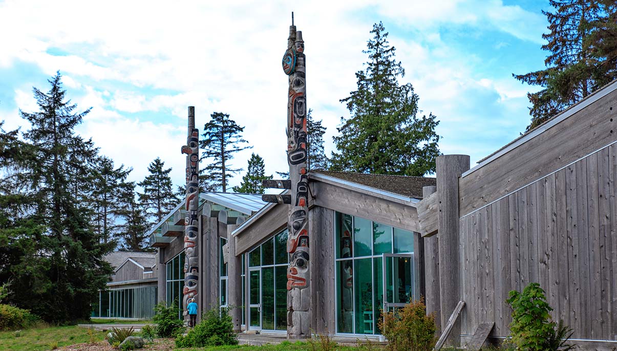
You can fly from YVR on a number of airlines into Sandspit or Masset, both on Haida Gwaii’s largest island where most amenities are located. You can also ferry from Prince Rupert. There are shuttles but a rental vehicle will give you the most flexibility to explore. Expect mileage to be added to your rental cost, unlike most destinations where unlimited miles are the norm. Accommodation is uncomplicated – predominantly lodges and hostels with breakfasts included. Pack for maritime weather – all conditions in a day – wind, rain, sun and cold. The Haida Heritage Centre in Skidegate is a must – history, performances and interactive learning. Check to see what’s going on and allow at least a half day here. There are high end fishing lodges in the area (salmon and halibut being the stars) with gourmet meals and prices to match. Camping, however, can provide equally memorable experiences in this special, spiritual locale.
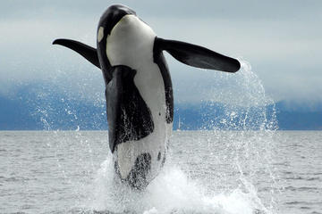
Vancouver Island Whale and Wildlife Tour
About the author:
Author, poet, songwriter Bill Arnott is the bestselling author of Gone Viking: A Travel Saga and Dromomania: A Wonderful Magical Journey. His articles and columns are published in Canada, the US, UK, Europe and Asia. When not trekking the globe with a small pack, weatherproof journal and horribly outdated camera phone, Bill can be found on Canada’s west coast, making friends and more or less misbehaving. www.amazon.com/author/billarnott_aps
Photo credit: Murray Foubister / CC BY-SA


 Our journey to the isle, first recorded as Savary’s Island by Capt. George Vancouver in 1792, began at the ferry dock in Comox, Vancouver Island. An hour twenty later we were rolling off the Queen of Burnaby into Powell River back dropped by the serrated teeth of the majestic coastal mountain range. A half hour north landed us in Lund, a village dating from the 1880s when the two Thulin brothers from Sweden set up shop and named the community after one back home. Free parking is at a premium here but paid parking is available for daily fee of $7.00 at Dave’s parking lot. Savary emerged, a rich green line across the horizon, as we strolled the village boardwalk. Then we were off to our evening abode; a bed and breakfast south of Powell River.
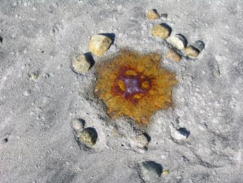 Stretched along the south shore, where we came ashore, were a line of substantial homes bordering the dirt road which we learned ran the length of the island, about 7.5 kilometres (.8 to 1.5 kilometres wide). Vehicles crowded a haphazard parking lot though few were to be found trundling along the low maintenance dirt roadways with the waning of summer. Admiring homes we walked as far south as the road allowed, drinking in views of beach and mountain. Perhaps appearing a tad bemused as we poured over a brochure we were rescued by a local resident who filled us in on the what’s and wherefore’s of Savary. She and her husband were just closing up their home for the season as were many of the locals; however there are a solid few who call Savary home full time and garner the fruits of civilized solitude in this stunning setting.
 She told us of the Savary Island B & B; a single floor sprawling log building we had just passed and admired. There had been a couple hotels on the island – The Savary, built in 1914 survived until it burned down in 1932 and the Royal Savary Hotel at Indian Point which was demolished in 1982. Now B & Bs, cabin rentals and a lodge offer accommodation options. The listed permanent population of 100 balloons to a couple thousand in the summer.
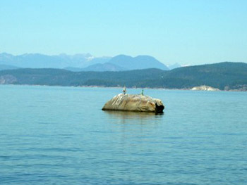 A black dot on the water proved a large curious seal. Masked Killdeer complained as they wheeled about behind us and, usually solitary, Loons swam about in a group. We wore no watches. Time took on its own rhythm. Afterwards we sat on a log gazing towards the sea and enjoyed a snack. Never ceases to amaze me how food tastes better in such settings.
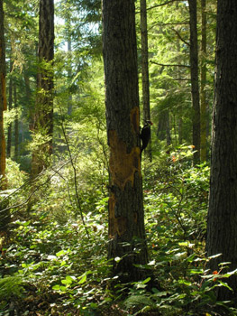 Striking out for the north beach and Mermaid Rock we returned to the dirt road, gloriously titled Vancouver Boulevard, running the spine of the island, and climbed to the height of land which was to take us through a protected and treed sand dunes section, devoid of development due to its fragility. Few cars and people frequented the roadway which felt much like a shady park walk.The takity takity tack of a noisy Piliated woodpecker echoed through the still forest; proving so intent on attacking his tree he took no notice of us. The protected zone is home to 10,000 year old sand dunes. The island is eroding steadily at both the north and south ends.
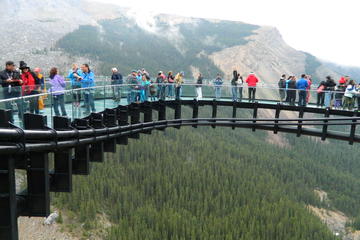
 And it is but a small part of the God’s carven world of the seven Canadian National and B. C. Provincial Parks hugging the Rocky Mountains’ Great Divide. So stunning the national parks; Kootenay, Banff, Yoho and Jasper along with the B.C. Provincial Parks Assiniboine, Hamber and Mount Robson were declared a UNESCO world heritage site in 1984.
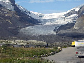
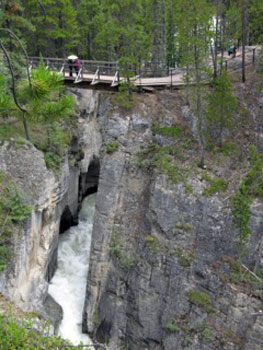 Our now grown children with children of their own were but pre-teens when we last drove the parkway between Lake Louise and Jasper and we were stunned to see how far the Athabasca Glacier, that long intrusive tongue of the massive Columbia Icefield, had retreated. Already in natural retreat there are signs acknowledging the decline that have been hastened by global warming. They spoke of the advancing flora chasing the fleeing glaciers and of the inherent change so bespoken for wildlife. Where once the icy tongue licked the opposite side of the valley, at its greatest extent in 1844, the long flight saw it now crawling into the very folds of the great icefield itself. Here, atop the World, the ice achieves depths of 100 to 365 metres; enough to engulf cities, skyline and all.
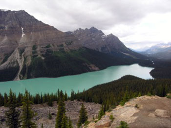
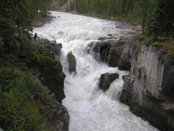 Turquoise hued Peyto Lake is a short uphill jaunt from the highway parking lot. Oft photographed and resident on many a calendar the lake is laid out resplendent, guarded by its mountains and replenished by thin cascades streaking across their faces. Named after historic early trader and guide, Bill Peyto, the lake is safely viewed from a guard-railed viewpoint.
 The Johnston Canyon waters ran cold and clear through the narrow chasm carved over the millennia, spilling white fury in misty display as they pass. It is claimed almost one million people annually trod its tended pathways, bridges and ramparts which swing over the very turbulence itself. Despite crowds politeness prevailed as people quietly stopped to let others pass. Cameras, hung at the ready – necessarily so as you would just take one picture only to find another waiting around the corner. At the lower falls (30 minutes in) rock walls appeared to almost close and the waters pounded into a pool hidden within a a hollow accessible through a carved tunnel at the end of a bridge crossing the chasm. Spectacular in the extreme, people lined up to experience the pounding, misty cavern.
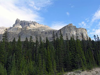 Our second site sat, a hidden Shangri-La, high above the opulence of Lake Louise with its glacial backdrop and turquoise waters. To reach Lake Agnes takes a bit of effort; wending the switch back trail to the rock outcrop upon which a log tea house sits and a thin cascade tumbles free to Mirror Lake far below.
 A short distance west from Takkakaw is the turnoff for Emerald Lake and the Natural Bridge. If it lacks the power of Takkakaw the Natural Bridge makes up for it in methodical carving of rock into forms as unique as a Henry Moore art piece. Where once a full natural bridge hung over the rage-whitened face of water but a vestige remains, itself a passing entity. Emerald Lake lies at the foot of the mountains, red canoes dotting its surface, even as the lodge recalls images of romance. At the parking lot a little ground squirrel community has entertained visitors for years. In the midst of wild beauty sits peace.
 During those family days in Golden we would take the winter drive to Radium Hot Springs and the Sinclair Canyon jaunt into the park under the red-eyed gaze of the canyon cliffs to immerse ourselves in the inviting hot spring pools. The bracing cold did not encourage lingering in the hallway leading to the protected pool access but once within its warming confines soothing sensation embraced the entire body. In my bearded days both beard and hair would freeze in Santa Claus fullness to be melted away with a luxurious dip underwater. Mists covered the pool surface in eerie fullness parting occasionally to bear witness to mountain sheep cavorting on the rocks above. Lounging in the warmth of the pool, an experience even more appreciated with the aches of age, and gazing up to the surrounding mountains, is meditative and renewing.
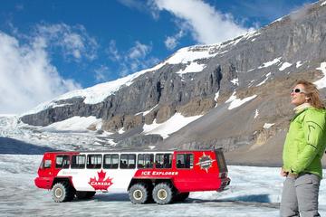

 The 10 minute ferry ride from Campbell River, which has been running since 1960, deposited us at the tail end of an armada of vehicles unloading at our destination; which proved ideal as it allowed us a leisurely drive and opportunity to gawk. That in turn gave us the opportunity to pull in for a coffee at the Cafe Aroma and drink in a little island atmosphere, replete with eclectic decor, local folks chatting, laid back pace and friendly servers. We garnered a coffee and discussed our touring route.
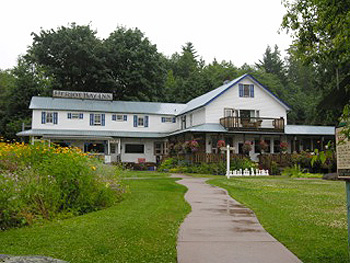
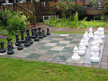 The hotel has been serving the island in one form or another since 1895 when Hosea Arminis Bull built the first incarnation. It lasted until a 1912 fire wiped the slate clean and it was rebuilt. Bull sold the place in 1926, two years after his wife had passed away and it remained in private hands until 2008 when it was purchased by the Community Custodial Concept Group with the stated desire of maintaining the edifice and service for the residents of Quadra and visitors. The stately lodge contains much of the old 1912 building but has been modified and expanded over the years. It gazes out over the bay and to the distant coast mountains beyond; enfolded in its gardens and lawn complete with a giant sized and manned chess board.
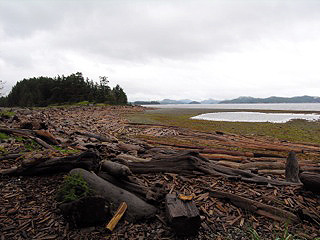 Our server at the pub suggested a trip to Rebecca Spit Provincial Park for a great look-back perspective. So informed we found and took the gravel roadway onto the thin two kilometre spit of land and found ourselves the chance to explore beach and trail; offering panoramas on either side of the spit. Driftwood and sea-lost logs were strewn about the seaward shoreline, like pick-up sticks, whilst the opposite shore hid the protected inner anchorage of Drew Harbour. A defined trail led through the trees running the spine of the spit and chanced us an opportunity to meet and chat with a local dog and his valet. None of us hurried in such a setting we chatted for a considerable while before returning to our respective treks.
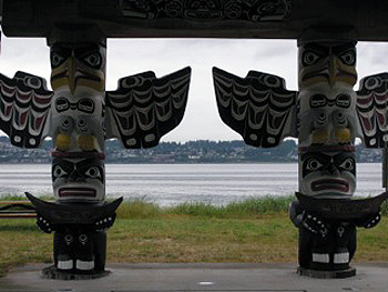 Putting aside our camera, as no photos are allowed in the building, we paid our admission of $10 per adult and began the experience. Cultural artifacts seemingly incorporating every conceivable aspect of the surrounding natural environment filled glass enclosures with captions telling of their story, purpose and people associated with them. Stories of the great potlatches, their purpose, nature and persecution by non Natives and eventual rebirth spelled out. We learned how the ceremonial treasures and regalia had been repatriated from museums and galleries throughout North America and a new home built for them overlooking the waters of their home, opening in February 1979. The present day centre was re-opened in May 2007. It is recommended you allow at least 45 minutes to make your way through this stunning collection and display of First Nations’ culture and artistic skill.
_-_Graham_Island_-_scenes_around_the_Haida_Heritage_centre_-_the_museum_buildings_-_(21533671266).jpg)