by Troy Herrick
Hunger pains, tongues sticking to the roofs of our mouths and the heat of the morning forced us to stop for breakfast in a town named Beit She’an as we were driving north to Tiberias. Finding a little strip mall restaurant, we ordered our food and then proceeded to see if Beit She’an was even listed in our guidebook. To our surprise what we found was that people had settled here for over 5000 years. Taking the life-sized poster of Justin Bieber, whose hometown is about a 90 minute drive from where we live in Canada, hanging in a nearby shop window as a good omen, we decided to check the ancient site out.
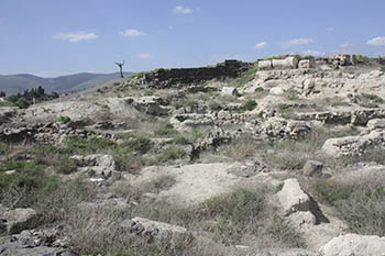
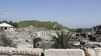 An inconspicuous mound (tel) outside the modern city of Beit She’an stands as silent witness to over five millennia of habitation. If such mounds could talk this one would have a lot to say about ancient civilizations; about the footprints they left here; about conquerors come and gone; and it all seems like only a moment in time.
Why did people continuously settle here you may ask? There was a reliable water source at nearby Harod Creek (Nahal Harod). Furthermore this site was strategically significant because of its location at the junction of the Jordan River Valley and the Jezreel Valley. The people controlling this city also controlled the routes from Jordan and inland to the coast and from Jerusalem and Jericho to the Galilee. You can see the strategic importance of the site as you enjoy the panoramic view from the top of the tel.
 The earliest dwellings that you see visible on the tel were constructed using flat clay bricks and date to the 3rd millennium BCE. Civilization here really only took off during the 12th to 15th centuries BCE under the Pharaohs of Egypt when the city was their administrative headquarters for this region.
Enter the 12th century BCE residence of Egyptian Governor Ramses-Weser-Khepesh. The Egyptian-style mud brick home, whose remaining walls are 4 to5 feet high, consists of a central hall surrounded by rooms on all four sides. Inside you find two circular stone bases, each approximately 5 feet in diameter and 4 feet high, on which wooden columns were placed to support the ceiling. Remaining décor in the house consists of a now broken statue of Ramses III that commemorates the Egyptian victory over the “Sea People” who invaded this area in the early 12th century BCE.
Fire destroyed the city in the mid-12th century BCE and with this Egyptian control evaporated. The stage was now set for the Philistines to move in and capitalize on the power vacuum, followed by the Israelites. In 1004 BCE, King Saul’s army fought the Philistines on nearby Mount Gilboa and the latter prevailed. The victors hung the dead bodies of King Saul and his three sons from the walls of Beit She’an (1 Samuel 31:10). To date, archeologists have not uncovered any portion of the city wall dating to that period. The Israelites would eventually conquer the city and the Philistines would disappear from history, although you can still occasionally meet one in a bar or pool hall.
You find the remnants of a gray stone Israelite citadel dating to the time of King Solomon on the tel. The Assyrians destroyed this fortress in 732 BCE (2 Kings 15:29) and then carried off the city’s residents into slavery. The tel remained in ruins until the 3rd century BCE when it was resurrected under the Hellenistic Seleucid Empire and named Scythopolis.

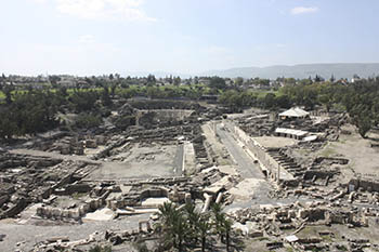
 The Roman General Pompey captured Scythopolis in 63 BCE and then the city really flowered. Focus shifted to the flatlands on the south side of the tel but not before the Temple of Zeus was constructed as the last major structure of any importance on the mound. You can still find some white marble column drums and Corinthian capitals from this temple on the side of the tel.
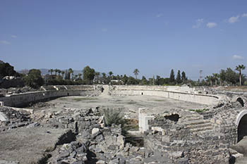
Roman Scythopolis was notable for its colonnaded streets paved with basalt stones. You find two rows of white marble columns lining each side of the street whose purpose was to support a roof over the elevated sidewalks. Public buildings and shops lined these sidewalks. Imagine middle class Romans shopping during the heat of the day under these covered walkways. They socialized at public bathes; they were entertained at the theatre and at other diversions including outdoor sports involving gladiators and indoor sports at the brothel.
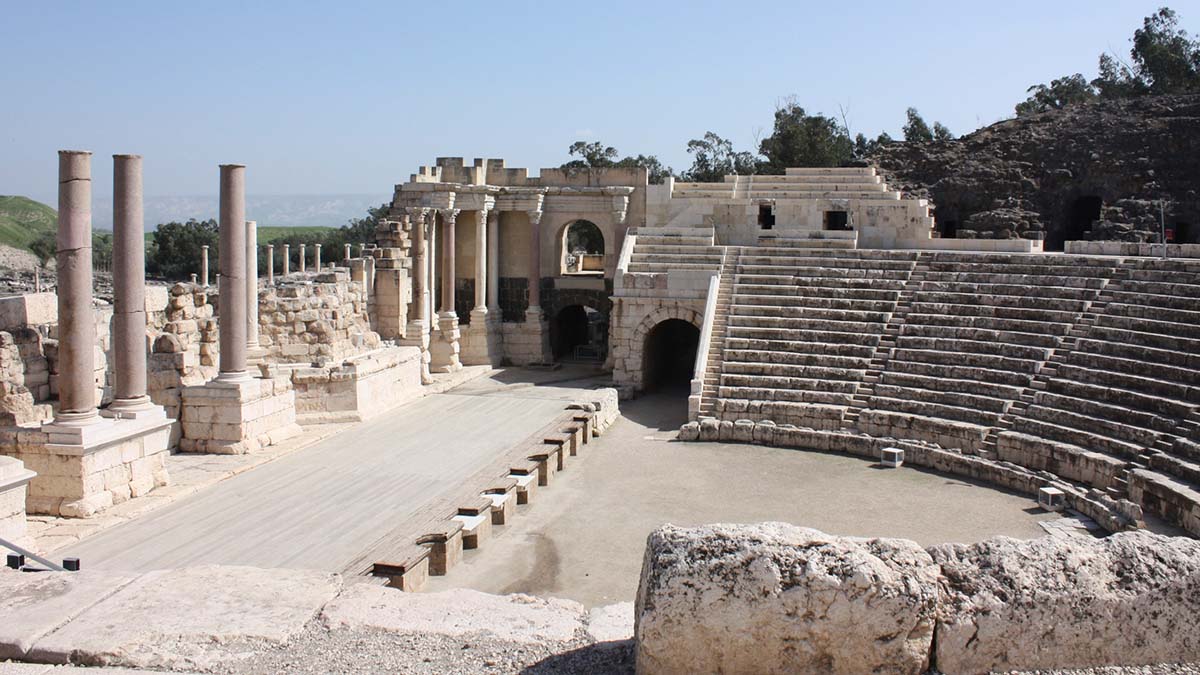
The Roman theatre [TOP PHOTO], still in use today, dates to the 2nd century CE. It originally accommodated 7000 people in three tiers of limestone seats but only the first tier survives today. A row of large pilasters outside the structure hints at the missing tiers. The scenery wall on stage facing the audience was originally 20 meters high.
No Roman city was complete without a bathhouse and Scythopolis boasted two of them, one on the east side of town and one on the west side. Citizens were leisurely ushered from the change room (apodyterium) to the steam room (caldarium) to a warm room (tepidarium) to a cold room (frigidarium).
Heating for the caldarium was facilitated using the hypocaust method where the flooring was heated from spaces below. You can see the exposed rows of stumpy brick cones that once supported the floor of the caldarium in the western bathhouse.
A thorough massage was also included for good measure. Grooming tools are displayed including an oil flask from which olive oil was poured onto the skin during a massage. There is also a scrapper for removing the oil after. Visitors should note that bath soap and shampoo had not been invented yet.

 The public latrine adjacent to the eastern bath house accommodated as many as 57 people seated on very public toilets set around a central courtyard. Each individual, male and female, sat on two smooth plinths extending from the wall as they discussed the business of the day with 56 of their closest friends. The sewage system consisted of a channel of running water beneath each row of seats that allowed for drainage. Feel free to sit down and take a load off.
The Sigma was a semi-circular plaza near the western bathhouse. The name of the plaza originates from the Greek letter sigma inscribed in one of the twelve rooms around its periphery. These rooms may have served as shops or possibly a brothel. One of these rooms features a mosaic of Tyche, the Roman goddess of good fortune, on the floor. She wears the walled city of Scythopolis as a crown and holds a horn of plenty filled with fruit and a fig tree in her hand.
 The Roman Amphitheatre dating to the 4th century CE accommodated 6000 spectators for gladiatorial battles and contests involving wild animals. The oval structure originally had 10 to 12 rows of seats of which only three remain today. The other rows were dismantled by Crusaders who were constructing a fortress nearby. A series of rooms with arched roofs at various locations around the outside of the amphitheatre may have served as cages for wild animals.
The Nymphaeum was a finely decorated public fountain building constructed in the 2nd century CE and rebuilt in the 4th century CE, possibly to repair damage sustained from an earthquake in 363 CE. Originally at a height of 13 meters above street level, the fountain was designed so that water flowed down two levels through pipes in the façade and into a central pool at the base. You can still see fragments of the Nymphaeum, including columns from the façade, which toppled due to a major earthquake in 749 CE. A scale model of the Nymphaeum at the site of the original gives you an idea of what the structure looked like.
Earthquakes are not uncommon in this area because the nearby Jordan Valley has a major fault line running through it. The end of Scythopolis came with the earthquake of 749 CE and the city never recovered after. However whether it is named Beit She’an or Scythopolis, this city will always be remembered in the Bible and the pages of history.
Private Tour: Nazareth, Tiberias and Sea of Galilee Day Trip from Tel Aviv – $96.67
from: Viator
If You Go:
By car, from the Sea of Galilee travel south on Road 90, turn right onto Road 71 towards Afula/Beit Shean, and shortly afterwards, left onto 7078. By bus: take the Egged Bus 412 from Jerusalem to Afula which stops in Beit Shean. Admission to Beit She’an National Park is 28 Shekels.
The Roman Amphitheatre is not inside the national park. Admission is free.
About the author:
Troy Herrick, a freelance travel writer, has traveled extensively in North America, the Caribbean, Europe and parts of South America. His articles have appeared in Live Life Travel, International Living, Offbeat Travel and Travels Thru History magazines.

Photographs:
Diane Gagnon, a freelance photographer, has traveled extensively in North America, the Caribbean, Europe and parts of South America. Her photographs have accompanied Troy Herrick’s articles in Live Life Travel, Offbeat Travel and Travels Thru History magazines.
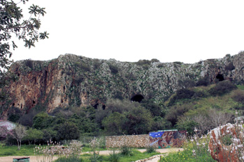

 The third owners of this piece of the Tanur Cave were Neanderthals. They comprised the Mousterian culture and they immigrated here 100,000 years ago and called Nahal Me’arot home for about 60,000 years. You can see a Neanderthal exhibit in the Garmal Cave where you find male and female figures dressed in animal skins. The stocky, muscular Neanderthals stretched animal hides out on frames and produced stone spear heads. There were also a number of dug out areas in the ground but it is not clear what these were used for. Contrary to popular opinion the males did not carry clubs over their shoulder.
 Herod the Great is most infamous for trying to eliminate the infant Jesus in the Bible (Matthew 2:16-18). At the same time he was also renowned as a prolific builder. All of his projects were built to impress but a number of them were designed with a unique purpose in mind. Masada was constructed as a fortress retreat in case the population revolted. The fortified palace at Herodium contains his tomb and of course there is the second Jewish temple in Jerusalem. The city of Caesarea by the sea (maritima), built between 22 and 9 BCE, was a man-made seaport named in honor of Caesar Augustus.
 According the Roman Historian Flavius Josephus, this theatre was the site where Herod Agrippa died as recorded in the Book of Acts (Acts 12:19-24). Herod Agrippa, grandson of Herod the Great, was the king of Judaea at the time.

 Hebron is the final resting place of the Patriarchs Abraham, Isaac and Jacob and their respective wives Sarah, Rebekah and Leah. Abraham purchased the Cave of Machpelah for use as a family tomb from Ephron the Hittite for 400 silver Shekels (Genesis 23:17). This cave is the second holiest site in Judaism.
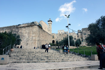 The Tomb of the Patriarchs is the centre of ongoing conflict between Palestinians and Jews. The site is maintained under tight security and segregated into both a mosque and a synagogue.
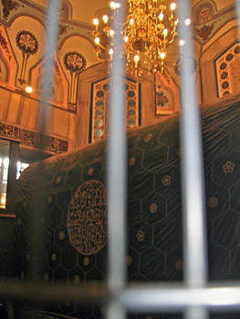 Exiting the prayer hall, locate Abraham’s cenotaph (Genesis 23:1-20) on your right. This is the most elaborately decorated monument in the complex. The cloth covering the cenotaph is divided into hexagonal sections, each with a gold embroidered flower blossom at its centre. Abraham’s monument is set within an opening in the wall that separates the mosque from the synagogue next door so that both Muslims and Jews can view it and yet remain segregated from each other.
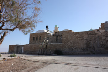 En route to Jericho, you pass by An Nabi Musa, a former caravanserai where Muslim travelers could rest for the night as they traveled to Mecca for the Hajj. The caravanserai houses a mosque dating to 1269 CE which was built by the Mamluk Sultan Baybers. Inside the mosque you find a second room containing a cenotaph covered in a silky green cloth embroidered with gold Arabic script. Muslims believe that this is the final resting place of Moses whose bones were removed from Mount Nebo in neighbouring Jordan by Saladin. Jews and Christians believe that Moses still rests on Mount Nebo to this day (Deuteronomy 34: 5-6).
 After a few minutes we continued on to Tell es-Sultan, the site of ancient Jericho. Just thinking about this city conjures up images of Israelites marching, the sound of trumpets and walls falling down (Joshua 6:1-21). What you find is a 15 metre high mound (“Tell” in Arabic) of earth covering approximately 2.5 hectares. Archeologists have sliced trenches deep into this mound and uncovered 23 successive settlements built atop each other. The oldest layer dates back to 8000 BCE. A number of signs highlight the structures found within each trench.
 The slope of one of the “Tell” layers dating to the Middle Bronze Age (1650-1550 BCE) was fortified by an earthen embankment with a mud brick wall at its summit. A large retaining wall at the base of the embankment was constructed from Cyclopean stones. This Cyclopean wall also supported a second mud brick wall at a height of 8 meters. This second mud brick wall, believed to have been about 70 centimeters thick, was uncovered in a collapsed state, possibly having been leveled by an earthquake. The nearby Jordan Valley is known to have a fault line running through it and earthquakes have been recorded at various times in history.
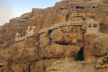
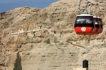 Exiting the archeological site, walk a short distance to the cable car and ride it up to the Monastery of Temptation set on the side of a nearby mountain. Administered by the Greek Orthodox Church, this monastery is situated on the traditional site where Jesus fasted for 40 days in the wilderness while being tempted by Satan (Matthew 4:1-11, Luke 4:1-13 and Mark 1:12-13).
 Inside the monastery, you pass down a long hallway that is open to the sky. This hallway runs along the sheer rock face where several caves have been hollowed out. The outer wall is a row of doors that open into rooms that have been cantilevered from the cliff.
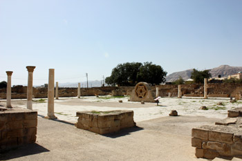 After descending by cable car, your next destination is Hisham’s Palace which was built by Caliph Hisham Bin Abdul Malik (724-743 CE) but never completed. The construction site was later leveled by an earthquake in 749 CE. Several layers of limestone blocks define all that remains of a once two-story building that served as a winter palace. The rooms of the palace were set around an inner portico and each corner of the structure had a cylindrical tower. A large hexagonal limestone star, cut from a single block of limestone, is believed to be all that remains of an upper window from this palace.
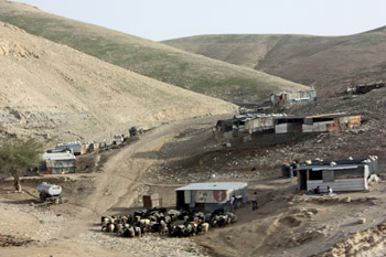 Just north of the palace you find the remains of a bath complex. The reception room features a beautiful mosaic on the floor depicting the “Tree of Life”. Three gazelles graze at the bottom of the fruit tree and a lion is ready to pounce on one of them. The bathing rooms, set along the northern wall of the bath house, were heated by hypocausts.
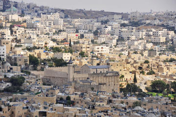
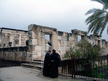
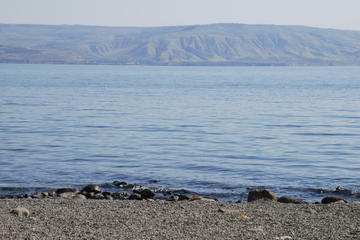
 Jesus settled in the ancient fishing village of Capernaum after having left Nazareth (Matthew 1:13, 9:1, Mark 2:1). Entering this archeological site today, you are greeted by a statue of St. Peter set just inside the “not-so-pearly” gates. Looking around, you may be surprised that the site before you is from the Byzantine Period and that nothing remains from the time of Jesus.
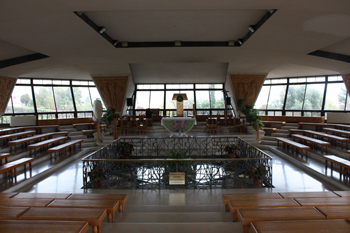 The octagonal shaped Catholic Church is beautiful in its own right. The brightly lit room features eight wooden carvings depicting the life of Jesus lining the periphery. Your eyes are drawn to the altar with the panoramic view of the Sea of Galilee behind it. From here, it is easy to imagine fishermen in their boats casting their nets into the lake.
 Constructed in 1933 on a rocky base at the shore of the Sea of Galilee by the Franciscans, this modest grey stone chapel is not the first church constructed on site. You can still see the remains of walls from an earlier church built in the 4th century CE on three sides of the building.
 The focal point of this church is the brown limestone outcrop that seemingly serves as a barrier between the congregation and the altar. According to tradition Jesus laid out a meal of bread and fish for his disciples upon this rock known as the Mensa Christi. You can easily imagine a number of tired fishermen coming ashore after a long night in their boat and finding a warm meal waiting for them, prepared by a man who had risen from the dead.
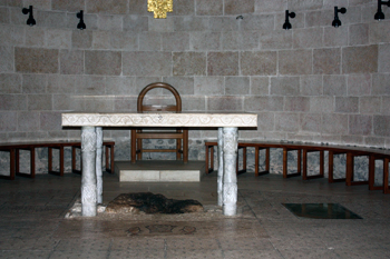 The focal point of this church with its basic interior is the dark brown limestone rock located beneath the simple stone altar. The faithful believe that this 0.6 square meter (5.4 square foot) stone was used by Jesus as a table when performing the miracle. History records that pilgrims have chipped away pieces of this stone over time.
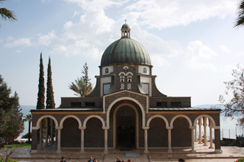 The Catholic Church on site, built in 1937, is set on the traditional site of Jesus’ Sermon on the Mount (Luke 6:20-22, Matthew 5:1-5). While there is no proof that the sermon actually occurred here, pilgrims have been drawn to this site since the 4th century CE, as evidenced by the ruins of a small church just down the hill from the present house of worship.
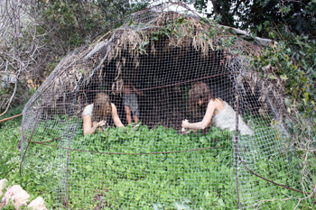
 Rani our tour guide opened a door and ushered us out onto the grounds of Nazareth Village, a reconstruction of Jesus’ old neighbourhood. As he did so, I suddenly remembered that Rod Serling began every episode of the Twilight Zone with “you unlock this door with the key of imagination”. We knew that we had arrived in the past when we were almost bowled over by an oncoming shepherd and his five sheep. With very little effort he ushered his flock into a circular pen constructed of standing sticks. My second thought was to watch where I stepped, just in case.
 A short distance away, seated outside the doorway of her stone house, a middle-aged woman sits and spins wool by means of a hand spindle. As some of the tour group found out, it is a great deal more difficult than it looks. Our guide outlines the steps required to process and dye the wool with natural colours from pomegranate and onion skin before it is woven into a garment.
 he young Jesus would have also attended school. In those days, the local synagogue served as the community school. We entered the house of worship to find three tiers of benches lining the greyish-white walls; a wooden bench at the centre of the room held the Torah Scroll. This synagogue and all other building were reconstructed by referencing the best New Testament and archaeological sources available.
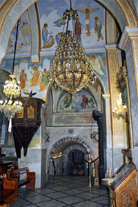 Present day Nazareth is a bustling city of approximately 70,000 people, a far cry from the 400 or so people living here at the time of Jesus. Work your way north along traffic-clogged Paulus VI Street and be thankful that you are not driving. Your first destination is St. Gabriel’s Church, the most distant site.
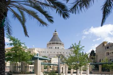
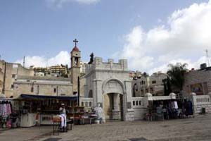
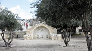 Retracing your steps along Paulus VI Street, turn right onto Casa Nova Street and arrive at the Roman Catholic Basilica of the Annunciation – the largest church in the Middle East. This church was built over the Grotto of the Annunciation, an ancient cave dwelling, traditionally accepted as being Mary’s home when she was visited by the Angel Gabriel. I could find no scriptural reference suggesting Mary lived in such a structure however.
 Above the grotto structure you find a large octagonal opening in the ceiling providing you with a view of the upper church. The dark brown cupola of the upper church roof is also visible, extending to a dizzying height of 60 meters. The ribs of the cupola represent the petals of an upside-down lily, symbolic of Mary’s purity. To visit the upper church, ascend the staircase just inside the doorway of the lower church.
 Christian tradition dating to the 7th century CE has it that Joseph’s house and carpenter shop were located on the site of the present Church of St. Joseph. Inside, the bare stone crypt features several rock-hewn chambers, a cistern and several silos for storing grain. A mosaic floor dates from Byzantine times. The nearby side chapel marks the spot where Joseph was visited by an angel as he slept (Matthew 1:20).
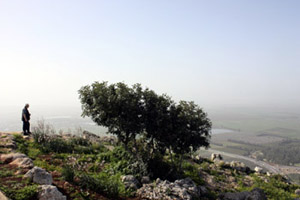 The Mount of the Precipice, 297 meters high, is now a park. From a lookout at the summit, you have a panoramic view of the surrounding area including distant Mount Tabor – the traditional site of the Transfiguration. But that journey will have to wait for another day. Instead you may wish to enjoy a leisurely stroll along the gravel path at the cliff’s edge and contemplate the meaning of your daytrip. As you take in the scenery, the essence of Jesus seems closer even though almost 2000 years have passed since he resided in his hometown of Nazareth.