by Glen Cowley
July 30, 1792. This day the long finger of Columbus reached Quadra Island. Be the legacy fair or foul it changed the island forever.
The summer of 1792 saw Captain George Vancouver of the Royal Navy exploring about the waters of the now titled Discovery Islands in his two ships the Discovery and the Chatham; setting his eyes on Quadra Island for the first time. By the time the Europeans returned the Coast Salish peoples they had initially met had been chased out by the We Wai Kai peoples whose descendants still call the island home and there guard their rich legacy. Unfortunately the return of the Europeans brought with it disease and vice which were to decimate the First Nations peoples.
We gazed across the short sea gap from the ferry dock at Campbell River to emerald cloaked Quadra; steaming with ragged wisps of clouds clinging in tatters to an endless army of trees. The day was to prove temperamental but the island proved no less endearing for its moods. At 35 kilometres long and 9 wide it is far from small island.
The Island eventually took on the name Quadra in honour of Captain Vancouver’s Spanish friend and fellow explorer Juan Francisco De La Bodega y Quadra (beats me why they don’t use his whole name?). The largest of the Discovery Islands Group Quadra is home to about 3500 individuals, most of whom reside in the southern portion of the island, and who represent a wide array of occupations. Three community cores exist at Quathiaski Cove (the ferry dock), Heriot Bay (from whence the ferry to Cortes Island sails) and the First Nations’ community.
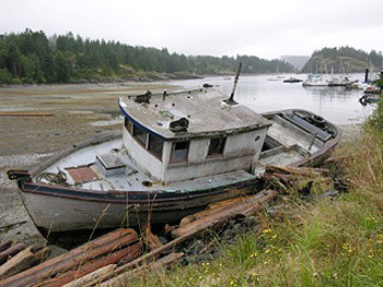
Quadra may have a more sedate atmosphere now but it was a thriving economic site in its earlier years. Beginning in the 1880’s came logging, then a fish cannery in the early 1900’s, which employed anywhere from 200 to 300 people, and the Lucky Jim Mine (gold and copper) which opened in 1903 and operated until it was burned out in 1925. The cannery went up in flames in 1941 and was not rebuilt. Word is the island experienced three devastating fires which depressed the economy until well after the end of the Great Depression.

 The 10 minute ferry ride from Campbell River, which has been running since 1960, deposited us at the tail end of an armada of vehicles unloading at our destination; which proved ideal as it allowed us a leisurely drive and opportunity to gawk. That in turn gave us the opportunity to pull in for a coffee at the Cafe Aroma and drink in a little island atmosphere, replete with eclectic decor, local folks chatting, laid back pace and friendly servers. We garnered a coffee and discussed our touring route.
That route took us first to Heriot Bay where we got to see the ferry to Cortes pull away and begin its 45 minute cruise into the misty overlay of islands and mountains populating the horizon. After exploring the shoreline on foot we wound our way back to the Heriot Bay Inn seeking sustenance at the pub housed therein.
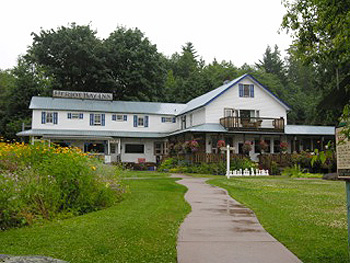
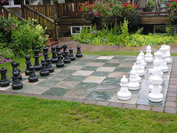 The hotel has been serving the island in one form or another since 1895 when Hosea Arminis Bull built the first incarnation. It lasted until a 1912 fire wiped the slate clean and it was rebuilt. Bull sold the place in 1926, two years after his wife had passed away and it remained in private hands until 2008 when it was purchased by the Community Custodial Concept Group with the stated desire of maintaining the edifice and service for the residents of Quadra and visitors. The stately lodge contains much of the old 1912 building but has been modified and expanded over the years. It gazes out over the bay and to the distant coast mountains beyond; enfolded in its gardens and lawn complete with a giant sized and manned chess board.
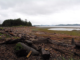 Our server at the pub suggested a trip to Rebecca Spit Provincial Park for a great look-back perspective. So informed we found and took the gravel roadway onto the thin two kilometre spit of land and found ourselves the chance to explore beach and trail; offering panoramas on either side of the spit. Driftwood and sea-lost logs were strewn about the seaward shoreline, like pick-up sticks, whilst the opposite shore hid the protected inner anchorage of Drew Harbour. A defined trail led through the trees running the spine of the spit and chanced us an opportunity to meet and chat with a local dog and his valet. None of us hurried in such a setting we chatted for a considerable while before returning to our respective treks.
Friends of ours had visited the Nuyumbalees Cultural Centre (meaning “The Beginning”) and urged us not to miss this unique treasury of First Nations artifacts and their setting. After first stopping at the band office to get directions to the centre, apparently not an uncommon experience for first time visitors, we found our way to the centre. Emerging from the car we were reprimanded by a lone bald eagle surveying the scene from high atop his tree perch. Then, as if co-ordinated, two other eagles swooped low over a field, starkly outlined against the deep green of the forest back drop, their banter echoing in the island silence.
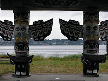 Putting aside our camera, as no photos are allowed in the building, we paid our admission of $10 per adult and began the experience. Cultural artifacts seemingly incorporating every conceivable aspect of the surrounding natural environment filled glass enclosures with captions telling of their story, purpose and people associated with them. Stories of the great potlatches, their purpose, nature and persecution by non Natives and eventual rebirth spelled out. We learned how the ceremonial treasures and regalia had been repatriated from museums and galleries throughout North America and a new home built for them overlooking the waters of their home, opening in February 1979. The present day centre was re-opened in May 2007. It is recommended you allow at least 45 minutes to make your way through this stunning collection and display of First Nations’ culture and artistic skill.
The modern day explorer ideally comes to this island to observe, learn and respect people, culture and environment knowing from history what can transpire when we fail to do so. It is not a place to hurry.
Open Boat Nanaimo Whale Watching
If You Go:
Heriot Bay Inn provides detailed information on the Inn and on things to see and do on Quadra
B.C. Ferries – for ferry schedule from Campbell River to Quadra Island
About the author:
Since 1994 Glen Cowley has parlayed his interest in sports, travel and history into both books and articles. The author of two books on hockey, a booklet on French Canadian influence in British Columbia’s history and over sixty published articles (including sports, biographies and travel) he continues to explore perspectives in time and place wherever travels take him. From the varied landscapes of British Columbia to Eastern Canada and the USA, the British Isles, Germany, France, Switzerland, the Netherlands and Greece he has found ample fodder for features. A return to Europe in 2014 is guaranteed to reveal new tales to tell.
All photos by are Glen Cowley.

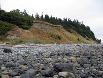 There are not many places on the Pacific Coast where we know for certain Vancouver walked, but this is one: the beach of Cape Mudge at the southern tip of Quadra Island, across Discovery Passage from Campbell River, British Columbia. In 1792, while charting the coast, Captain Vancouver visited here with his two ships, the Discovery and the Chatham. At that time, a Coast Salish village known as Tsa-Kwa-Luten thrived atop the sandy cliff. While the British ships sat at anchor on July 13, 1792, the natives paddled out in canoes and greeted the crews with fish and wild fruits in exchange for European articles of trade.
 An array of masks is the main feature: ravens, wolves, bears, killer whales, mosquitoes, double-headed serpents, all used in potlatch dances. Included in each description is the original owner, and some of their photographs are also on display. Many have Anglicized names such as Billy Assu and Amos Dawson, but their Kwakwaka’wakw names translate to honourifics such as “Always Giving Potlatches” or “High Ranking in Feasts”.
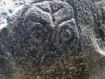 I learn that after Captain Vancouver’s voyage, a branch of the Kwakwaka’wakw known as the Lekwiltok descended from the north in their war canoes, with firearms acquired from European traders. Between 1792 and 1850, they raided and occupied numerous Salish villages and eventually commanded all of Discovery Passage—all save Tsa-Kwa-Luten, the village atop the sandy cliffs at Cape Mudge. So well fortified by nature, the Lekwiltok decided it was impossible to attack.
 Tsa-Kwa-Luten Lodge is one way the native people of Cape Mudge have met the challenge of living in today’s society. The spacious lounge is designed like a Big House with a vaulted ceiling, the walls decorated with traditional art, including cedar paddles and button-blankets. The dining room features contemporary First Nations art. I feast on cedar-planked salmon, sip local Quadra Island wine, and gaze at the sunset over Vancouver Island.
