Travel Thru History

Historical and cultural travel experiences

  • Home
  • Airfare Deals
  • Get Travel Insurance
  • Writers Guidelines

Canada: 10 Reasons to Visit Medicine Hat, Alberta

Medicine Hat Tepee at night

by Darlene Foster

Medicine Hat, Alberta, is not often high on anyone’s must-visit list, if it’s there at all. But it should be. There are many reasons to visit this oasis in the Canadian prairies, here are ten of them.

The Name

Who wouldn’t want to visit a place with such a unique name? There are many stories about how the city acquired its unique name derived from the original First Nation’s name Saamis, which means The Medicine Man’s Hat. All the legends involve a feather headdress. One story tells of a battle between the Blackfoot and Cree in which a retreating Cree Medicine Man lost his headdress in the South Saskatchewan River at the place where Medicine Hat became a town. The city uses a feather headdress as its symbol. The locals simply call their town, “The Hat” and residents are often called, “Hatters”.

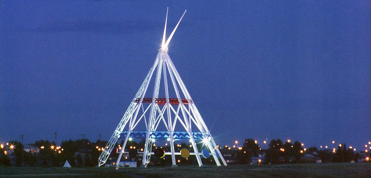
The World’s Largest Tepee

World's largest tepee
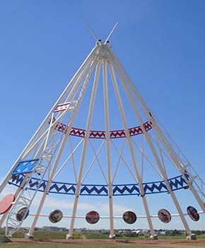
It’s hard to miss this towering structure as you enter Medicine Hat on the Trans-Canada Highway from either direction. Originally constructed for the Calgary 1988 Winter Olympics, the Saamis Tepee is a tribute to Canada’s native heritage. The colours of the structure are symbolic, white for purity, red for the rising and setting sun and blue for the flowing river. It is the World’s Tallest Tepee standing over 20 stories high, weighing 200 tonnes and capable of withstanding 150 mph winds. The ten round storyboards inside the Tepee are hand painted by various First Nations and Metis artists depicting native culture and history. Each storyboard comes with a written description by the artist. There is something magical about standing inside the large open-air Tepee on a sunny, prairie day. It makes me realize what a rich cultural heritage my country has.

Medalta Pottery

Medalta pottery factory
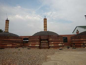
The city is blessed with clay perfect for making pottery, both functional and decorative. The pottery business once flourished in this century-old factory and its earthenware is renowned all over the world. The Medalta Pottery site has now become a museum, ceramic arts facility, art gallery and community hub where live music, markets and social events are held. One can wander the area and view the four huge brick beehive kilns, check out the museum and learn about the people and industry that helped make Medicine Hat. The gift shop sells replicas of the original pottery, made on site. No visit to Medicine Hat would be complete without a stop at the historic Medalta Pottery.

The Esplanade Arts and Heritage Centre

Esplenade museum displayIf you enjoy visiting the past, the museum located in this state-of-the-art facility is a delight. The displays follow the original First Nations People, to the settling of the west by Europeans, through the Second World War and the swinging sixties to present day. It really is a virtual walk through time. An ominous iron lung, a reminder of the polio scare from the early 1950s, will send a chill through you. Sepia coloured photo albums and audio recordings add to the experience. Besides the permanent display, interesting temporary exhibits can be viewed as well. An exhibition of women’s undergarments through the ages caught my attention on one visit. The centre is also a perfect place to take in musical and dramatic performances. Outside the building stands a bronze sculpture commemorating the German people from Russia who were instrumental in settling this area. I was proud to find my great grandfather’s name inscribed on the plaque.

James Marshall’s Sculptured Brick Murals

James Marshall sculpture
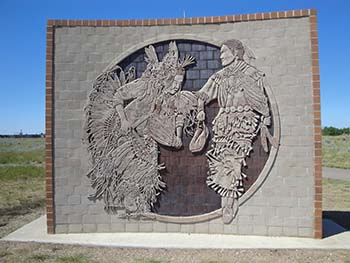
James Marshall is an internationally acclaimed Medicine Hat potter. He is renowned for his large-scale sculpted brick murals which can be found across Canada and overseas. Dozens of these murals are scattered about the city depicting its history and character. You will no doubt spot some as you make your way around. A splendid example of Mr. Marshall’s work can be seen at the Saamis Tepee as well as at the local Dairy Queen. A map from the Tourist Information office near the Saamis Tepee is available if you wish to take a self-guided tour to view these amazing works of art.
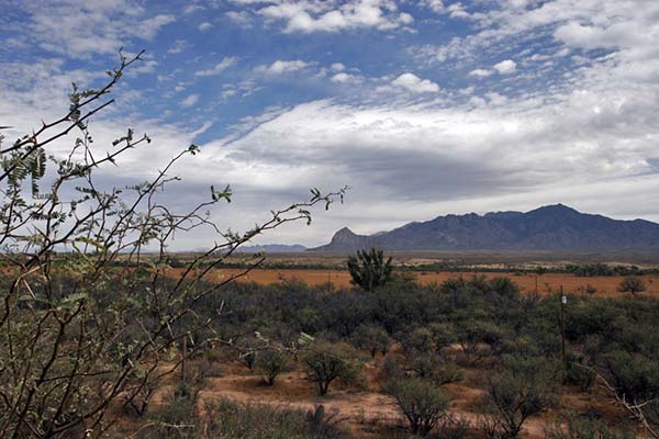
Red Rock Coulee

Red Rock Coulee
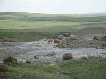
An interesting day trip to Red Rock Coulee, 56 kilometres (35 miles) south-west of Medicine Hat will not disappoint. This little-known area is a wonder to behold. Large, perfectly round, red boulders are scattered around a 324 hectare (800 acre) prairie landscape. Some of these boulders are up to 2.5 metres (8 feet) in diameter and are among the largest of these in the world. Virtually in the middle of nowhere, you will most likely have the place to yourself. It is like being on another planet! Research indicates these boulders were formed in prehistoric seas that once covered the area. Sand, calcite and iron oxide collected around a nucleus formed by shells, leaves or bones and grew as the circulating waters deposited more layers. The reddish colour comes from iron oxide. And I thought they were the result of a meteor shower! This is a great place to hike among the stones and view the prairie landscape. The only wildlife we saw were the resident mosquitoes which made us glad we brought bug spray.

 St. Patrick’s Roman Catholic Church

A prominent landmark in this city is St. Patrick’s Catholic Church. Inspired by the medieval cathedrals in Europe, it is said to be one of the finest examples of Gothic Revival architecture in all of North America. The church was declared a National Historic Site in 1990. Building began in 1912 and completed in 1914, with a number of renovations and improvements since. The amazing round rose windows, installed in 1955, were imported from France. New solid wood doors at the pointed-arch entrance were added in 1979. What is most striking is the copper roof affixed in 1977 covering the 170-foot twin spires that can be seen for miles. It is lovingly known as St. Pat’s by the local citizens.
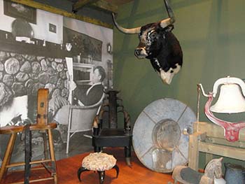
Pioneer Village

Pioneer Village, located on the Medicine Hat Exhibition and Stampede grounds, is a collection of heritage buildings from the surrounding area including a general store, a church, a fire hall, a school and a blacksmith shop. Step back in time as you enter each building. The General Store is stocked with items from the past, with the original prices. Pails of Rodgers Golden Syrup, a ten pound tin for eighty-five cents, rest beside Aunt Jemima Pancake Mixes, and ashtrays in the shape of the legendary cowboy hat. How about a curling sweater or a wooden rocking horse? The yellowed calendar on the wall features Edward VIII and is dated January 1937. It’s like time stood still – or a Doctor Who episode.

The Farmer’s Market

If you are lucky enough to visit this fair city on a Saturday, a stop at the Farmer’s Market should be on your list. This is where you can stock up on local produce, farm fresh eggs, homemade jams and pickles, Eastern European delicacies such as perogies and mouth-watering desserts like kuchen; a pie-shaped coffee cake filled with custard, fruit and my favourite, cottage cheese. It’s best to come early as these popular items sell out fast. Tables of local crafts and art are available for sale as well. Stop by and visit with the friendly vendors who always have time for a chat. You will not come away empty-handed.

The Historic Downtown

downtown Medicine HatWalking around downtown, past replicas of the original gaslights that line the streets and huge trees planted a hundred years ago shading heritage brick buildings, you can relax and forget the hustle and bustle of large urban cities. Stop and play a game of chess on the large chessboard by the well-stocked library. The original Monarch Theatre, where kids in the past could watch a Roy Rogers and Dale Evans feature for twenty-five cents, still stands. There are many well-kept parks, overflowing with colourful flowers to wander around and contemplate life. Enjoy a coffee or a bite to eat at the many coffee shops and restaurants downtown, serving wholesome, homemade fare. The accommodating residents and shopkeepers, as hardy as the extreme weather, will answer any questions you might have and share a story or two.

So instead of driving through Medicine Hat on the way to somewhere else, or just stopping for gas and a Tim Horton’s double-double, stop and stay awhile. You’ll be glad you did.

If You Go:

Medicine Hat is on the TransCanada Highway, 296 Km (184 miles) east of Calgary and 465 Km (289 miles) west of Regina.

Air Canada flies into the recently renovated Medicine Hat airport.

About the author:
Darlene Foster is a dedicated writer and traveller. She is the author of a series of books featuring Amanda, a spunky young girl who loves to travel to interesting places such as the United Arab Emirates, Spain, England and Eastern Europe, where she always has an adventure. When not travelling herself, Darlene divides her time between the west coast of Canada and the Costa Blanca of Spain with her husband and entertaining dog. www.darlenefoster.ca

Do You Need A VISA To Visit Canada?
Get Canada VISA Information Here

Photo credits:
World’s largest teepee at night by Ken Eckert under the Creative Commons Attribution-Share Alike 4.0 International license
All other photos by Darlene Foster.


Tagged With: Alberta attractions, canada travel, darlene foster, medicine hat Filed Under: North America Travel

An American History Lesson: Gettysburg, Pennsylvania

cannon at Gettysburg

by Susmita Sengupta

In the years 1861-1865, the United States fought what is known as the greatest war in American history, the Civil War. It was a war between the free Northern states also called the Union states and the slave holding southern states also known as the Confederate states of America. At stake were the issues of states’ rights versus federal rights and the abolishing of slavery. Abraham Lincoln had just been elected President in 1860 and he was an abolitionist. The Confederate states were afraid that life as they knew it was in danger and they fired the first shots even as Lincoln was taking office in March 1861, thus heralding the beginning of the Civil War.

Of all the various places that the war was fought, Gettysburg, in Adams County in the state of Pennsylvania, stands out for very important reasons. The battle fought here was not only the bloodiest battle of the Civil War but also became the turning point in United States history.

Our family decided to visit this historic place on a fall weekend trip, the primary focus definitely being the Gettysburg Battlefield.

We started our tour at the Visitors Center where there are a multitude of options on how one wants to experience the battlefield and its monuments. From personalized guided tours in your car to guided bus tours to bike rides to augmented reality tours using a rented iPad, the choices are numerous. We decided to do it the old fashioned way, driving on our own through the battlefield using the official map and guide.

monument at Gettysburg
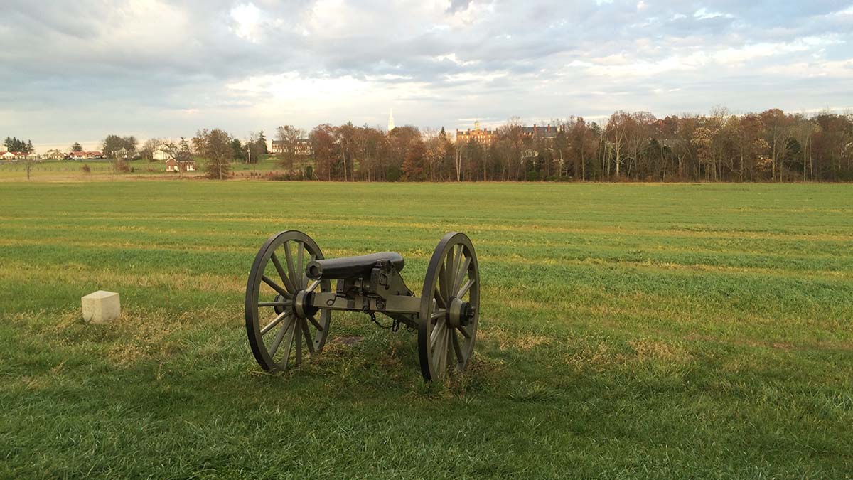
The Gettysburg Battlefield spreads out over about a twenty five square mile area and is dotted with monuments, cannons, and markers identifying the historic events that unfolded here from July 1-3, 1863. No matter the kind of tour one decides to undertake, visiting the site is an emotional experience. The self-guided tour is beautifully organized and one can easily follow the entire sequence of events of those three days chronologically by following the map provided at the Visitors Center. With time on our hands, we decided to spread out our tour over the whole day by first just doing a drive by through the entire national park followed by time spent at the museum and visitors center and then returning back to the battlefield to stop at various monuments for a detailed and closer look.

At the Visitors Center, the principal attraction is the Cyclorama painting platform, a truly massive 360 degree oil painting by Paul Philippoteaux from the 1880s that illustrates Pickett’s Charge from the third day of the Battle of Gettysburg. While viewing the painting, I felt as if I had a front seat to the eventful happenings of that day. On the third day of the battle, Confederate Gen. Robert E. Lee and his troops started an infantry assault on the Union troops of Maj. Gen. George G. Meade at Cemetery Ridge. The attack was led by Maj. Gen. George Pickett and the Confederates were driven back and they had to withdraw. They suffered a decisive defeat that concluded the Battle of Gettysburg. For history aficionados, the Gettysburg Museum at the Visitors Center is a treasure trove of information and one can easily spend a couple of hours exploring the various galleries. These galleries tell the story of the Civil War and the Battle of Gettysburg through exhibits, artifacts and interactive visuals from the viewpoints of everyone affected by the war.

Gettysburg is equally famous around the world for President Abraham Lincoln’s “Gettysburg Address”, a 272 word speech that he delivered here in November 1863 at the dedication ceremony of the Soldiers’ National Cemetery at the battlefield. Considered a landmark speech of American history, it reaffirms the importance of human equality as defined by the Declaration of Independence and restructures the Civil War as a struggle for the same.

Wills house plaqueAt the Wills House Museum, located in downtown Gettysburg, visitors can see the room where Lincoln stayed the night and prepared the final draft of Gettysburg Address. The house was the home and office of David Wills, an attorney who was the driving force behind the creation of the National Cemetery.

A little crunched for time, we were unable to tour the house but decided to visit the Shriver House museum instead. This museum that offers a civilian’s perspective of the Civil War is the 1860 home of George and Hettie Shriver. We walked through the beautifully restored home and in the process learned about the effects of that war on the life of the regular people of Gettysburg. I discovered that George Shriver volunteered to fight for the Union troops in 1861 while his wife Hettie and their two daughters continued with their life at this house. When the war came to Gettysburg in July 1863, Hettie decided to move to her parents’ farm a few miles away with her children. What she didn’t know is what we know now. That farmhouse was situated between two hills known as Big Round Top and Little Round Top, the two sites where some of the worst fighting took place. They lived through the battle in that house and returned back to their home on July 7th and found out that their home was now being used as a hospital and had been taken over by Confederate soldiers. It was fascinating to visit the attic and hear about the Confederate sharpshooters who had taken up positions there to fire at the Union soldiers and two of whom died there during the siege.

covered bridgeIf you get tired of all the Civil War related sightseeing, Gettysburg also offers some other places of interest. One such place is the Sachs Covered Bridge, one of four such bridges in Adams County and arguably the prettiest. Though this bridge too has a war related history, the Confederate soldiers retreated by marching across it, what catches your eye here is the beauty of this wooden bridge and the surrounding landscape. Although the effects of autumn weather were not yet seen, I could imagine how pretty the entire place would look once the trees showed their dazzling fall colors.

The next day we decided to take in the other attractions of Gettysburg, namely its charming downtown area filled with cafes, restaurants and gift shops selling folk art and Americana. Of course there are also stores selling authentic Civil War memorabilia and artifacts and we found a lot of antique stores as well.

Gettysburg turned out to be an ideal weekend vacation destination with a mix of history, culture and shopping but one can also spend a more leisurely week visiting other places of interest such as the Eisenhower National Historic Site, the weekend retreat of President Eisenhower and his wife Mamie that also served as his home after his presidency and the Hall of Presidents and First Ladies. A longer and more leisurely visit would also be perfect to explore the natural splendor of the surrounding Adams County.

If You Go:

Destination Gettysburg

National Park Service Gettysburg

Gettysburg Foundation


About the author:
Susmita Sengupta is a freelance writer who loves to travel. She and her family have traveled to various parts of the USA, Canada, Europe, the Caribbean, Middle East, Southeast Asia and India. She resides in New York City with her family.

All photographs by Susmita Sengupta

  1. One of the many cannons at the Battlefield
  2. Monument dedicated to soldiers from New York
  3. Wills House exterior
  4. Sachs Covered bridge


Tagged With: Civil War battle sites, Pennsylvania attractions, USA travel Filed Under: North America Travel

Pennsylvania: Oh Little Town of Bethlehem

Wilbur Trust & Lehigh Valley RR building

by K.A. Thomsen

There is no place like Bethlehem, Pennsylvania. Nicknamed by locals the “Christmas City,” it is the most peaceful place on earth. You get the sense that the land is at rest, and maybe it is. It was spared the anguish and bloodshed of the French and Indian war that raged from July of 1754 to 1763 literally all around it. The main reason for this was simply because its founders, the Moravians, had paid for their land. The had no desire to civilize or displace the first inhabitants of the Americas. They just wanted a place to live free from religious persecution.

Three hundred years earlier, the denomination began when small groups of Bohemians and Moravians (present day Czech Republic) had broken off from the corrupt Catholic Church, under a young zealous Bible scholar named Jan Hus. He was later burned at the stake for heresy, which only angered the local populace and fueled the revival which he had initiated. This in turn threatened the Catholic monopoly in the area and so began the Hussite wars. Almost 300 years later, in 1722, the tensions between the two groups were still so bad that a small group of Hussites from Moravia fled to Germany. They were sheltered there by wealthy Count Zinzindorf, who had enough land to do so comfortably, for almost 20 years.

Nazareth, Pennsylvania was founded first in 1740 and then, in 1741, came Bethlehem. The first immigrants held their services and wrote their hymns in German. They lived in segregated housing arrangements called choirs: one for single sisters, one for single brothers, and one for married couples. They loved music, and the choir designation referred to the fact that they were always singing, in order to keep themselves uplifted while they worked the menial jobs of a pioneering existence.

From the Moravians came the first orchestra in America, The Bach Choir, (which is still going on to this day), and the iconic Christmas Star, the Love Feast (on Christmas Eve) and Moravian sugar cake.

The star is indeed the symbol of Christmas City, USA. In 1937, to commemorate this, a giant star was placed on South Mountain which overlooks the city, guiding those who traverse the labyrinth of streets and modern buildings to find historic downtown nestled in the centre.

Gemeinhaus
Gemeinhaus

Historic downtown Bethlehem is home to several treasured buildings including the oldest log structure still in use in the USA, the 1741 Gemeinhaus, which now holds the Bethlehem museum; the Brothers, Sisters, Widows and Miller’s stone houses; the Old Chapel; the Sun Inn; The Bell Tower; the 1762 Waterworks; (also a national historical landmark, as America’s first pumped municipal water system) and the archeological remains of the buildings dedicated to butchery, tannery, dying, pottery and oil.

The Moravians are a kind and unassuming sort, seeking always to share their faith in a respectful way and only with those who are open to hear. Their focus remains ecclesiasticism, personal piety, missions and music. They were the first denomination to start a 24 hour prayer vigil, and once it began, it continued for over 100 years.

The first few times I visited Bethlehem I was too young to remember much. But when I was six and in first grade, they sent me to the Moravian Academy (built on my family’s lands) for one day.

Next to the Academy is the Cemetery, where all the gravestones are flat and arranged by name and marital status rather than family, because to the Moravians, the dead are all equal “before God.”

I remember going to visit my grandmother on July 4 one year (I was 12), and the minister opened up the Bell Tower for us to climb to the very top. We could see over all the rooves of the entire town, and then there were fireworks.

We had been touring around the Lehigh Valley Music festival for hours, absorbing all the culture our souls could possibly sponge up. There was a local polka competition, food vendors, book sellers, beeswax shapes, ornaments and candles of every possible denomination.

They also have a store – the only one I’ve ever known of – dedicated 365 to everything Christmas. What else could you expect from The Christmas City, USA?

Several Christmases before we were in Bethlehem for the love feast. It is held in the colonial Old Chapel, on Christmas Eve. Everyone brings their children and in the middle of the service, ushers bring out mugs of hot chocolate and giant cookies. Then, they take up the dishes and hand out beeswax candles. It smells amazing.

Before the end, the whole sanctuary is darkened and filled with the light of hundreds of candles held by the children and their parents lining the pews.

On my recent trip we took the bus from nearby Allentown to the Newark airport. Within the first 20 minutes I spotted a large sign on a building that said, “Moravian Academy.” I pointed it out to my mother.

Apparently it was the middle school and new athletic grounds build on land that had also been in my family. It had been owned by an aunt or first cousin of my great-grandmother and her husband who made a lot of money with a successful business back in the 1920’s before there was such a thing as income tax in the Americas!

I tip my hat to the 18 brave souls who volunteered to be the first settlers in Bethlehem…it was a dangerous place back then, largely wild; the surrounding lands were populated by various first nations tribes with differing values and political alliances. One never knew if accepting the hospitality of one would make them an enemy of the others, as history proved it sometimes did.

When I was a child my grandmother gave me a book. It told the story of how the first trombones came to Bethlehem, and how through those instruments a miracle was delivered, and a war with the natives averted.

Today, in the United States the Moravian church has become allied with the Episcopal and Methodist denominations. But some still exist in Canada, Germany and other parts of the world. For example, when I went travelling in India we came upon a Moravian church and school in the highest human settlement on earth sitting in the Himalayas, at 18,000 feet. We stayed there for a week and ran an after school club at the church and also spent time with the children at school. I still have pictures of my teammates in front of the Moravian logo and symbol which is a lamb holding a blue flag with a white cross in the middle, and says in Latin, “Our Lamb Has Conquered, Let us Follow Him.”

If You Go:

This is an excellent website that tells about the history and locates everything Moravian.

Wikipedia has a great recreation and entertainment section:   i.e.: “The city is famous for its annual Musikfest, a largely free, ten-day music festival that draws over a million people to the city each August. Since its founding in 1898, The Bach Choir of Bethlehem has been attracting thousands of visitors to the annual Bethlehem Bach Festival,[36] now held largely on the campus of Lehigh University and on the historic grounds of the Moravian Community. Other festivals include The Celtic Classic, which celebrates Celtic culture, food and music,[37] and the SouthSide Film Festival, a non-competitive, not-for-profit film festival. The city has also been the past, and current host of the North East Art Rock Festival, or NEARFest, a popular 3-day Progressive rockmusic event…

The city is the location of Pennsylvania’s largest casino, the Sands Casino Resort Bethlehem, located on the former Bethlehem Steel property.

The Lehigh Canal provides hiking and biking opportunities along the canal towpath which follows the Lehigh River in Bethlehem. Both the Lehigh Canal and the Monocacy Creek are popular for sport fishing, and both are stocked annually with trout.

In spring 2011, the city opened Steel Stacks, a ten-acre campus that showcases music, art, festivals, films and educational programming throughout the year.[42] It is located in the backdrop of the blast furnaces of the former Bethlehem Steel plant.”

The motto of the Moravian church is: “In essentials, unity; in nonessentials, liberty; and in all things, love”

Visit Bethlehem PA

Get Downtown Bethlehem – Festivals

Everything you need to know about Bethlehem, PA

Mitchell, Barbara: Tomahawks and Trombones, Carolrhoda, 1982.

About the author:
K. A. Thomsen is a BC writer with an emphasis on historical fiction and poetry. Her first novel, The Hidden Valley, a junior fiction cowboy story set in the Chilcotin wilderness was published in August 2016. It deals with tweens coming of age, issues of land stewardship, first nations peoples, ranching, and horsemanship. She is married with two children.

Photographs:

  1. Wilbur Trust & Lehigh Valley RR HQ  by Shuvaev / CC BY-SA
  2. Gemeinhaus by Jerrye & Roy Klotz, MD / CC BY-SA


Tagged With: Bethlehem PA attractions, Moravians, USA travel Filed Under: North America Travel

Florida Winter Estates of Edison and Ford

Winter home of Thomas Edison

Inspiring Glimpses of Legendary Ingenuity in Fort Myers

by Connie Pearson 

As you walk the grounds and tour the buildings set on 20 acres facing McGregor Boulevard in Fort Myers, Florida, you will admire the beauty of the surroundings while being educated about the contributions of two great American inventors.

I would like to live about three hundred years. I think I have ideas enough to keep me busy that long.
– Thomas Edison

By the time Thomas Edison reached his 40th birthday, he already had 500 U.S. patents. Two years before, in 1885, Edison bought 13.5 acres in Fort Myers along the Caloosahatchee River and quickly had a 357-foot dock built. That dock became very crucial when it took six ships to deliver all the materials needed for the house he was building for his new wife Mina and the house next door to be inhabited by his friend and business partner, Ezra Gilliland, who is credited for introducing Thomas and Mina.

Edison was attracted to the Fort Myers property for three main reasons: 1) He was tired of the New Jersey winters and loved South Florida’s great weather; 2) He loved fishing; 3) The property already had bamboo growing on it, and he was using bamboo filament in his light bulbs at the time.

Gilliland and Edison had an unfortunate parting of the ways, and Gilliland sold his property to Ambrose McGregor, for whom the street in front was eventually named. Four years later, McGregor died, and his wife sold the house back to Edison. The houses are mirror images of each other. Boston Architect Alden Frink designed them. The materials were precut in Maine, shipped south and were move-in ready within four months. Edison gave a lot of input into the homes’ designs to take advantage of the river views and the breezes, with French doors, sweeping windows and high ceilings.

Interior of Edison winter homeFor eleven years, Edison’s home was the only property in Fort Myers with electricity. The story is told that the first night his electroliers (how Edison referred to the chandeliers since they used light bulbs instead of candles) were illuminated, the whole town came out to watch. At bedtime, the lights went off, and the whole town walked back home in the dark. Indoor plumbing wasn’t added until 1890.

Edison home swimming poolThe swimming pool and bath house were built in 1910. Interestingly, the pool is only 5 ½ feet deep, and there is an 11-foot diving board. Supposedly, the diving board was really just an ornamental addition and not one that was used by the Edison children.

Furnishings, including the wicker pieces on the porches, linens and light fixtures that are on display are original to the homes. The only items not original are the light bulbs, which have been replaced by modern ones, and paper goods which have been stored under climate-controlled conditions.

Banyen trees in Edison yardOne of the most remarkable sights on the grounds is one of the largest Banyan trees in the world. It was about 4-feet tall when it was planted in 1927 but now covers an entire acre, even after some recent trimming! A giant bougainvillea has survived and thrived since it was planted by Mina Edison in 1947, and the remainder of her rose garden can be seen near the main house.

When the Edisons decided to line the street of their property with Royal Palms, the City of Fort Myers admired the sight so much they lined the remainder of the street with the same trees, a stretch now extending for about 14 miles.

Mina Edison’s Moonlight Garden was designed by Ellen Biddle Shipman, known as “the dean of American female landscape architects.” Anchoring that garden is Edison’s study where he was known to read books, take naps and smoke cigars.

Visitors can enjoy a garden shop selling lots of tropical plants, a gift shop, a museum, and an Edison laboratory set up exactly as it was when he did much of his rubber research. That research explains the many latex-producing ficus trees planted throughout the grounds.

Henry Ford didn’t come into the picture until he and Thomas met in 1896 at a conference sponsored by Detroit Edison Illuminating Company where Ford worked as a machinist. The two creative minds bonded immediately. They worked together to develop a better storage battery for the Model T and later joined with Harvey Firestone to form the Edison Botanic Research Corporation (EBRC).

Early Ford carThe Ford family finally came to visit the Edisons in Fort Myers in 1914. Many famous names, such as the Colgates, the Kelloggs, Connie Mack (famous professional baseball player, manager and team owner) and Herbert Hoover spent time as guests of the Edisons, but apparently, Henry Ford wanted his own house when he went to South Florida. In 1916, he purchased “The Mangoes” an existing estate bordering Edison’s property. Edison spent 4-6 months a year in Fort Myers, but Ford only came for about two weeks every year, always in time to celebrate Edison’s birthday on February 11. Henry Ford gave Thomas Edison a Model T in 1916, but Edison was never successful in learning to drive it. He finally hired a chauffeur who drove him and his family for thirty years.

The stories shared by the capable docents on the grounds will instill great pride in the entrepreneurial spirits of these two remarkable men. Henry Ford’s primary museum is at Greenfield Village in Michigan, but many important artifacts, cars and personal items are found in Fort Myers.

In 1931, the year Thomas Edison died, he spent six months of that year working on rubber research. It is said that he only slept three to four hours each night because his head was so full of ideas. He ended up with 1,093 U.S. patents at the time of his death. 500-600 more projects were either unsuccessful or abandoned. It’s mind-boggling to think of all he might have invented if he’d been granted the 300 years of life he wanted.

Some of his more compelling quotes:

Of all my inventions, I like the phonograph the best.
I owe my success to the fact that I never had a clock in my workroom.
We don’t know one millionth of one percent about anything.

If You Go:

The Edison and Ford Winter Estates are open seven days a week from 9:00 a.m. to 5:30 p.m. Historian-led tours are $30 per person, and self-guided audio tours are $25 per person.

Edison and Ford Winter Estates are located about a half hour from the Fort Myers airport. Rental car companies are on site at the airport. Most chain hotels are represented in Fort Myers, but I would urge you to consider a beach house, condo or hotel on nearby Sanibel or Captiva Islands. There is a $6.00 toll bridge accessing those islands. The Ding Darling National Wildlife Refuge and the world-famous shelling beaches are worth exploring.

Notable restaurants include The Bubble Room, historic Old Captiva House at ‘Tween Waters Inn, and Doc Ford’s Rum Bar and Grille at South Seas Plantation on Captiva and on Sanibel Island.

About the author:
Connie Pearson is a native Alabamian, wife of 47 years, mother of three and grandmother of 13. She is a retired elementary music teacher who is now a travel writer and blogger with more than 120 articles in 20 print and online publications. She is the author of Telling It On the Mountain: 52 Days in the Life of an Improbable Missionary. Visit www.theregoesconnie.com

Photos by Connie Pearson

  1. Edison’s original winter home
  2. Edison’s original interior furnishings
  3. Edison’s swimming pool and diving board
  4. Edison statue with large banyan tree
  5. Henry Ford early vehicle with historian Joseph leading a tour


Tagged With: Florida attractions, Fort Myers tours, Henry Ford winter home, Thomas Edison winter home, USA travel Filed Under: North America Travel

Fort Bowie Arizona, a Frontier Landmark

Remains of Ft. Bowie corrals and stables

by Victor A. Walsh

The eight-mile dirt road zigzags through the parched hills like the river of no return. The grasses and thistles, now a golden brown, sparkle in the November sunlight. Not a blade of grass moves in the stillness. Hills and gullies stretch out in all directions like a wrinkled, windblown sheet.

At the parking lot we meet an older maintenance worker with National Parks. His deeply furrowed face is as rough as the terrain. He tells us that the Fort Bowie National Historic Site is about a mile-and-a-half down the trail. I ask him about the jutting mountain peaks on the horizon in front of us. “Those are the Chiricahua Mountains,” he says. “Geronimo use to talk to his gods up there.”

on the way to Fort Bowie
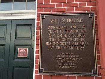
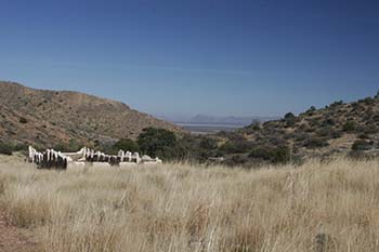
The trail winds through meadows dotted with mesquite and rimmed by hills. The foot-high grasses, bent and curled by gusting winds, have turned a rich golden yellow. It is warm, quiet — an inviting place of solitude.

But 155 years ago, the last Indian war in the United States erupted here between the native Chiricahua Apache and the U.S. military. The incident that ignited the bloodshed was the kidnapping of a local rancher’s son. Settlers falsely accused Cochise, the chief of the local Chiricahua, of taking the boy. When he was not returned, a brash young officer, Lieutenant George N. Bascom, detained and executed several of Cochise’s relatives. Cochise, in turn, executed his American and Mexican hostages, and a tenuous peace was broken forever.

Markers along the way identify the remnants of a Butterfield Stage station attacked by Cochise’s warriors, the restored post cemetery, a reconstructed Apache wickiup, and the Chiricahua Apache Indian Agency adobe ruin.

A weathered picket fence encloses the cemetery. Long, narrow shadows from the rows of white headstones slice through the sunlit gold-brown grass. In 1895, the army removed the remains of all military personnel for re-internment at the San Francisco National Cemetery. Twenty-three gravesites remain — nearly all civilians employed at the fort.

I stare at the names on the headstones: John Finkle Stone, age 24; John Slater, age 35; John McWilliams, age 26. Below each name are the words, “Killed by Apaches.” They died young, too young, as did Geronimo’s two-year old captured son, Little Robe, buried here after dying in 1885 from dysentery.


Hillside near Ft. BowieFacing the sun, I look at the brown hills dotted with mesquite and scrub oak. Behind them, invisible in the glaring light, are the Chiricahua Mountains, the spiritual homeland of a people banished by conquest. Today they are part of Chiricahua National Monument.

Beyond the cemetery, the trail follows a dried river gulch shaded by thickets and saplings. Here, tucked below the pass is what drew the Apaches, Spaniards, and Americans: a year-round spring. Today its water is but a trickle, played out by history.

Climbing up an incline, I see a line of crumbling mottled-brown adobe walls in the glinting sunlight sprawled across Apache Pass. An unfurled American flag hangs limply from its post on the parade ground.

Fort Bowie artifactsI walk among the ruins — the massive cavalry barracks, the stables, and ordinance building — trying to imagine a world gone: barking dogs, a wagon lumbering up the old stage route; soldiers with their mounts and carbines. The officer’s quarters, a two-story, Victorian-style frame building with a shingled mansard roof, once stood on the far side of the parade ground. Now nothing remains but a marker stranded amidst clumps of dry grass.

I wonder what the men and their families thought or how they coped with the physical isolation of this remote place, and the lurking presence of a determined enemy defending their homeland.

Rebuilt and enlarged in the late 1860s to protect the spring and overland route, Fort Bowie never had walls, but it played a vital role as the base of operations in the last Apache war against the shaman and war chief Geronimo.

After his surrender, Geronimo and thirty-six of his followers were brought to the parade ground and loaded into wagons on September 8, 1886, destined for military prison in Florida. The entire tribe, including those who never resisted, suffered a similar fate until 1913 when 265 survivors — many born in captivity — were at last released from Fort Sill, Oklahoma.

With Geronimo’s final surrender, the fort’s raison d’être ended. In 1894, it was closed, and the small garrison reassigned to a new post in Colorado. The abandoned post quickly fell into disrepair as locals carried off timbers, windows and doors. In 1911, the Chiricahua lands west of the fort, once protected as a military reservation were auctioned off.

In the fleeting light, the adobe walls and stone ruins stand like sentinels to a time when the Chiricahua Apache waged the last major Indian resistance against the United States. They had lost their families, homes, horses, guns, and freedom—everything but their honor.

If You Go:

Getting There:

The Fort Bowie, which became a National Historic Site in 1964, is located 13 miles south of Bowie on Apache Pass Road off I-10 and 20 miles southeast of Willcox off 186. From Tucson it is 166 miles via I-10.

Attractions:

The rural community of Willcox, founded in 1880 as a camp for Southern Pacific Railroad construction crews, has a colorful history that its citizens are striving to preserve. Many of the late 19th-century commercial buildings are still intact, including the restored railroad depot, a National Historic Landmark.

The forest of spires, balanced rocks and pinnacles in nearby Chiricahua National Monument is well worth a visit. To the Chiricahua the mountains were known as the Land of Standing-Up Rocks. The monument’s 12,000 acres encompass two deserts and two mountain ranges, and is home to a wide range of plants and animals.

Accommodations:

Hotels, inns and B&Bs are available at Bowie, 14 miles north of the ruin on I-10 and Willcox, 27 miles west along AZ-186. Bonita Canyon Campground at Chiricahua National Monument is open year-round. Sites are available by online reservations. RV hookups and camp sites are available nearby at Alaskan and Mountain View RV Parks on I-10.

For More Information:

Fort Bowie National Historic Site, 3203 South Old Fort Bowie Rd, (520) 847-2506. There is a visitor center and rear access road for disabled visitors.

Fort Bowie, Arizona, Combat Post of the Southwest 1858-1894 by Douglas C. McChristian, University of Oklahoma Press.


About the author:
Victor A. Walsh’s passion is the trans-Missouri West with a focus on early explorations and their continuing impact on our world today. His historical and travel essays have appeared in American History, True West, Literary Traveler, California History, Journal of the West, Rosebud, Desert Leaf, among other publications.

Photos by Richard Miller and Victor A. Walsh


Tagged With: Arizona travel, Fort Bowie Filed Under: North America Travel

  • « Previous Page
  • 1
  • …
  • 36
  • 37
  • 38
  • 39
  • 40
  • …
  • 72
  • Next Page »

MORE TRAVEL STORIES:

Echoes of Empire: Tracing Roman Britain in the Bath Ruins

Honoring Sir Edmund Hillary (1919 – 2008)

Hadrian’s Wall: A Walk Through History

The Mystery of Fairy Stone State Park in Fayerdale, Virginia

Famous Food of Meghalaya: A Flavorful Journey Through Traditional Delights

Wine, History, and Heritage: How to Time Travel Through France’s Legendary Wine Regions

Eternal Splendor: Unearthing the Beauty of Kyoto’s Temples, Japan

Acre, Israel: A Living Historical Monument


SEARCH

DESTINATIONS

  • Africa Travel
  • Antarctica travel
  • Asia Travel
  • Australia travel
  • Caribbean Travel
  • Central America Travel
  • Europe Travel
  • Middle East Travel
  • North America Travel
  • Oceania Travel
  • South America Travel
  • Travel History
  • Travel News
  • UK Travel
  • Uncategorized
  • World Travel
facebook
Best Travel Blogs - OnToplist.com

Copyright © 2026 Cedar Cottage Marketing | About Us | Contact | Privacy Policy | Terms & Conditions | Copyright Notice | Log in