Travel Thru History

Historical and cultural travel experiences

  • Home
  • Airfare Deals
  • Get Travel Insurance
  • Writers Guidelines

Stepping Back in Time on the Acadian Shores of Nova Scotia

Historic Acadian Village Nova Scotia
by John Geary

Walking into the visitor centre at the Historic Acadian Village of Nova Scotia is like walking through a time portal to life on the province’s southwest shores in the early 20th century.

Visitor CentreThe centre is a modern facility, but once you step out its back doors, you’re walk back into history.

The Acadian people were actually the first to settle this area, back in the early years of the 17th century, when it was part of New France. They often had to deal with an uncertain existence during North America’s colonial history, as England and France fought for possession of North America.

As a result of a 1755 treaty from one of the many wars fought between the two 18th-century “superpowers,” the English removed many of the Acadians from their homes and re-settled them in their American colonies. Many ended up going to Louisiana, which was then a French territory and their descendants became what we refer to as Cajuns (“A-Cajuns”) in modern times.

KEEPING THE PAST ALIVE

Duon HouseToday, many of the interpreters (costumed or otherwise) working at the Nova Scotia village are descendants of the area’s original inhabitants, who eventually made their way back to Nova Scotia, including the area around West Pubnico, not far from Yarmouth on the southwest shore of the province. They help make the village a living museum for visitors from June to October each year. Through them, you get to see how Acadians lived here during the early part of the 20th century as their culture grew and thrived. Many of them see this as an important way to keep their language and culture alive while sharing it with others.

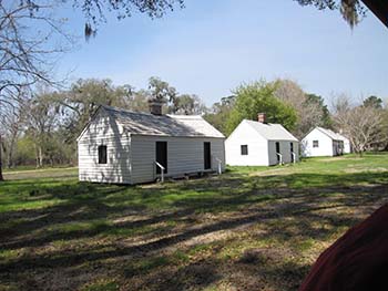
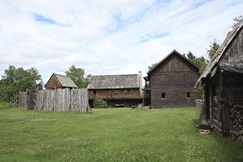
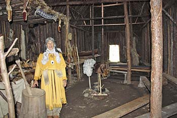
Upon first stepping through the time portal, one of the first buildings I encountered was the former home of one of the residents, Charles Duon. This house, built in 1832, was separated into two dwellings. The roof of the house’s main section originally had a gentle slope but was later raised. They then added a gable, which was common aspect of many Acadian homes.

old fashioned woodstove
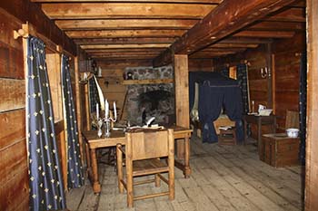
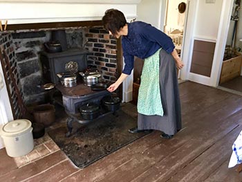
Walking through the building, I enjoyed not only viewing actual furniture and household appliances from the previous two centuries, but also watching interpreters going the processes of cooking, sewing, and cleaning as the people living then performed those tasks.

Watching them gave me a whole new appreciation for modern cooking methods and cleaning utensils.

I was really looking forward to seeing the boat shop, but I forced myself to see some of the other buildings that sat between the start of the dirt road through the village and that facility.

Continuing along the path toward the harbour, the next stop was the community post office. Originally built to provide a place to make shoes in the 1800s, it was turned into a community post office in the early 1900s. Today, you can still buy stamps and postcards at the village gift shop and have them mailed from the old post office – a postal time hop, in other words.

blacksmith shop
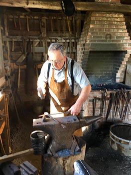
Of course, just about every historical village you visit has a blacksmith shop, and the Acadian Village is no different. The Reuben Trefry blacksmith shop opened for business back in the late 1800s and served the village until 1938. Today, you can watch the same kind of work being done as it’s been done through the centuries: the on-site blacksmith will heat up some metal, then pound it into shape on the anvil, creating various tools and other objects.

LET’S BUILD A BOAT!

And then…finally – I reached the boat shop!

I was not disappointed.

carpenter working on doryThe carpenter who was working on building an actual wooden dory took time from his wood-working to answer questions and explain how flat-bottom boats were built traditionally for fishing the local waters during the early 1900s (apparently, the secret is in the ribs!) The time-tested techniques used then were obviously much different than those used in modern boats but given the materials and tools they used back then, the reasons for the processes they used all made perfect sense.

Just across the path from the boat shop sits the August Duon Fish Store (the Duons were obviously one of the prevalent families in the village!) There you could purchase dried, salted fish that had been processed at any of the several shops found along the shores.

Originally, the Acadians were agriculturalists, but when they returned, they often ended up settling on land that was not as suitable for agriculture as the land they’d previously lived on. Never ones to turn down a challenge, they turned to the sea to help them earn a living.

Now if you’re going to catch fish in any era, you need to have nets. Not all much has changed in that respect; what has changed is the types and size of nets used – and the way they’re repaired and maintained.

fisnihg shanty
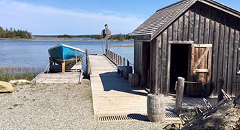
Dropping into the shanty by the shore at the end of the village path, you can see just how nets and lobster traps were repaired then. It was a tedious but crucial task to keep them in good shape in order to earn a living from the sea. Drop into the shanty, and you can watch nets being repaired the old-fashioned way, a process that probably had them swapping fish stories while they worked at it – and if you’re lucky, you’ll hear a few stories as well, as I did.

Next it was time for me to do a bit of “sitting on the dock of the bay.” A few steps away from the shanty is the crib style wharf, similar to the small docks that once dotted the shores in the area. Back then, fishermen had to plan their departure and return from fishing to coincide with the high tide in order to dock and unload their catch.

It was a gorgeous sunny day, a great opportunity to enjoy the views of the bay, watching modern-day kayakers paddle by, their plastic craft quite a contrast from the partially built wooden boat I’d seen earlier.

 NATURE, TOO

That was when I decided to check out the village’s nature trail. It’s a short little path that leads away from the shanty to an area that includes a seasonal salt marsh, great for seeing birds. However, when I visited, it was dry, so there was not really much bird life to see. There was a nice little picnic area, though, where one could sit and enjoy a snack, and watch the waters of the bay roll past.

lighthouseBacktracking past the shanty and across the main road, I followed another pretty path through the woods to visit the village lighthouse. Before heading there, I stopped to take a peek into the village’s root cellar. Opened as part of the village museum in 2017, the root cellar would have played an important role in the life of the Acadians of this region and surrounding areas. Built in the days before electricity, it kept vegetables from freezing in the winter months and kept food cool during the warmer summer months.

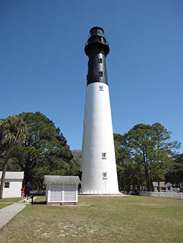
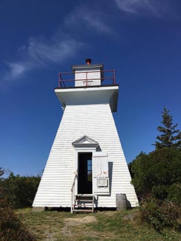
Then – on to the lighthouse! It was a short little walk…to a short little lighthouse. Built in the early 1900s on the mainland at Abbott’s Harbour, it was built to replace a lantern hoisted on a mast on Abbott Island.

Once I’d spent a bit of time checking out the lighthouse (I couldn’t actually go right inside it), it was time for me to head back through the woods and back along the dirt road path to the visitor centre to browse for some souvenirs and grab a snack before heading out.

As I drew closer to the centre, I saw a pair of cows munching on the grass contentedly in a fenced-in field not far from the doorway back to the present. I thought how little had changed for them through the past five centuries, as chewing their cuds in 1604 would be the same experience as chewing them in 2019.

DID YOU KNOW…

Some quick facts about Acadian culture:

Acadians have their own flag, which flies proudly at many places in the province – including outside the village.

Acadians have their own anthem.

There is a National Acadian Day, celebrated on June 19.

There is an Acadian World Congress. Southeastern New Brunswick and Prince Edward Island will host the next congress from August 10-24, this year.


If You Go:

The village is only open from June 4 to September 28, but it’s open seven days a week during that time.

It is located at 91 Old Church Road, Lower West Pubnico, Nova Scotia. That’s about a 30-minute drive from Yarmouth; not quite three hours from Halifax (and an international airport).

This is their 20th anniversary, so they may some addition special events going on. To get details, you can contact them via email at villagehistorique@ns.aliantzinc.ca You can also phone Toll free at 1-888-381-8999.

You may also learn more about the village at the official website, levillage.novascotia.ca/

About the author:

John Geary is a professional freelance writer and photographer who specializes in travel, nature and wildlife, and history. He lives in Vancouver, B.C. Canada with his wife Ann and their three parrots, Coco, Congo, and Einstein. He previously wrote about the Yukon for TravelThruHistory.

Photos by John Geary:

Visitor Centre
The Duon House
Cooking the old fashioned way.
Blacksmith hard at work
The secret of building a good dory is in the ribs!
The shanty – lots of nets to fix, lots of stories to tell!
The lighthouse

Tagged With: acadian culture, acadian village, cajuns, Canada tourism, nova scotia travel Filed Under: North America Travel

Palenque and the World of the Maya

Palenque Temple of the Count

by George Fery

Hidden in the verdant hills of the Sierra Chapaneca in the beautiful State of Chiapas, southern Mexico, is the ancient capital of the B’aakal kingdom. The name of the city then was Lakam-ha’ in Maya-Yucatec language. The town is today called by its Spanish name, Palenque.

Remains of impressive Maya temple-pyramids and palaces abound all over Mesoamerica. Many archaeological sites overwhelm the visitor by their monumental architecture. Few are as remarkable as Palenque for its fine palaces, temples and architecture. The layout of this UNESCO World Heritage Site, and its location within a jungle clad mountain range, is replete with springs, streams and falls, overlooking the plains of Tabasco.

The 1998-2000 PMP-Palenque Mapping Project under Mexican INAH-Instituto de Antropologia e Historia management, and FAMSI-Foundation for the Advancement of Mesoamerican Studies (famsi.org), led by Dr. Edwin L. Barnhart, recorded and mapped 1481 structures at Palenque. The PMP covered 0.850Mi2/2.2Km2 of the city jungle shrouded plateau. The area referred to as “Central Palenque” open to visitors, account for less than a hundred buildings and structures. All others are still covered under a dense tropical rain forest. At its height during the Classic, the urban population may have reached 7500-8000 souls.

Central PalenqueEarly morning, when nature awakes and the mist from the jungle slowly lifts, the welcoming calls of howler monkey greet visitors, together with shrieking tropical birds. Palenque’s ancient name probably came from the cluster of small rivers, that come out from the upper slopes of the mountain that overlook the site. The ancient name Lakam-ha’ translate as “Big Waters” for its numerous falls through ravines and over great natural stair-steps. The Yemal K’uk’ Lakam Wiz or “Great Mountain of the Descending Quetzal”, stands over the great city of Classic times (250-950).

A Great Maya Lord

Shrouded in the mist of time one wonders, who lived here? At its height from the end of the 5th to mid-9th century, it was an important metropolis, and a major player in political and trade in the region. Its greatest achievement however, was in architecture and the arts. The 7th century saw the birth and death of one of the greatest Mid-Classic Lord in Maya history, K’inich’ Janahab’ Pakal.II (603-683).

By all accounts Pakal was the greatest Lord of the B’aakal kingdom, as it was then called. His title, like lords before and after him, K’uhul B’aakal Ajaw translate as “Sacred Lord of the B’aakal Kingdom”; it underlines the commanding secular and religious functions of Maya lords. His 68 years reign (615-683), was one of the longest in Maya history. Pakal inherited the kingdom at the young age of 12 but was sacred Lord at 23. During the interregnum, his mother Sak K’uk’ Ajaw governed as regent, not as a Lord of the realm.

Pakal’s wife, Ix Tzak B’u Ajaw was from Ux Te Kuh’, the northwest city where his family took refuge, when Palenque was burned by the Kan Kingdom proxies, twice, in 519 and 611. She is buried next to her husband mausoleum, The Temple of the Inscriptions. Her resting place is Temple XIII, referred to as the Temple of the Red Queen, for the large amount of hematite, a red pigment iron oxide, found in her sarcophagus.

Temple of the SkullTemple.XIII and Temple.XII, known by its enigmatic name, Temple of the Skull, are adjacent to each other on an east-west line. They are separated by Temple.XIIA not yet fully excavated. The Temple of the Skull is named after the skull shown at the base of its west pier. It is the skull of a rabbit, whose shape is seen on the full moon. The rabbit representation on the moon is common in the New World and Asia. The skull on Temple.XII is that of Goddess.O, the Aged Goddess of the Falling Moon, to whom the temple was probably dedicated.

The PalaceThe Palace, open to visitors, is built on a massive irregular quadrangle; it was a ceremonial and administrative building. Large stairways on three sides allowed access to the vaulted halls that ringed the quadrangle. The south side stairway was ceremonial, while the north side was utilitarian. The complex is made of a complicated system of vaulted buildings, lengthy halls and three courtyards.

The PMP project discovered a palace complex west of central Palenque, that is still under the jungle canopy, and is significantly larger than the Palace. Of note are the names assigned to buildings by archaeologists, that do not always reflect their true function at the time; “temple” and “palace” on the record are but terms of convenience.

In the middle of the Palace complex, the Tower’s third floor holds an altar built of limestone mixed with a large quantity of seashells from the Pacific. The altar may have been dedicated to ceremonies linked to the legendary Primordial Seas. The belief may have been supported by numerous marine fossils found in the limestone of the mountain range.

The Tower at PalenqueOn the Palace east side runs the Otolum River, its banks walled up as a canal, a key part of the important and elaborate, water management system of the city. Bathrooms were found below the plaza level. The Palace was mainly used for administrative and ceremonial purposes, for the ruler, members of the nobility with bureaucratic functions, scribes, high priests and formal state receptions of ambassadors or important visitors.

People did not reside in the Palace; the tropical humidity and thick stone walls were not conducive to ventilation. They lived outside in fine traditional wattle and daub structures set on stones with a short vertical wall. Thanks to their semi-open construction, it allowed for ventilation to pass through, a plus for comfort in a tropical environment, especially in rainy season. The residential area was located close by, east of the Palace, beyond the Otolum river canal.

The Rise and Fall of History

The history of the city is tumultuous with frequent wars, as well as great and not so great Lords at its head. At the death of her father, Ix Yohl Ik’nal Ajaw (reigned 583-604), was the only woman elevated to K’uhul B’aakal Ajaw or Sacred Lord of the B’aakal kingdom. Her reign was plagued by hostility from within and without. Regional antagonism was fueled by two enemies for different but complementary reasons. The first was Tortuguero, a city located in the northern plains of Tabasco. Leaders of that city claimed the title of K’uhul B’aakal Ajaw that Palenque rightly demanded as its historical right. A deep-seated enmity endured that fed their antagonism for years.

The second is that of Calakmul, the powerful K’an kingdom to the northeast in Yucatan that fueled both cities’ antagonism for its own benefit: control of trade routes and that of the Usumacinta river, a major waterway. Its other proxy Tonina was only 41Mi/80Km distant from Palenque, in today’s Ocosingo valley. This enmity will remain a thorn in Palenque’s side through murderous wars, up to its collapse in 850-900.

There may have been another reason for this lasting enmity with the powerful K’an kingdom. Palenque traded and probably had political contacts, with the powerful metropolis of central Mexico, Teotihuacan. Calakmul then may have perceived Palenque as a Mexican proxy in the Maya heartland, which would explain such a long-lasting and violent antagonism.

Faces of defeatIn 659 Pakal got his revenge against the K’an kingdom, as shown in the West Court of the Palace. The carved limestone slabs show six sahals (state officials) of Santa Elena and Pomona, other proxies of the Great Jaguar militaristic totem, Calakmul. They are shown bound and ready for execution, facing the carved steps across the courtyard that recount Palenque’s defeats and burning in 599 and 611.

The antagonism with Tonina in particular, will last to the end of Palenque’s dynasties. K’inich K’an Joy Chitam, Pakal 66 years old second son was captured in battle in 711 and held prisoner for seven years. Unlikely, he was freed by Tonina, but the reason for his release and the terms attached to his freedom, are unknown. After his release, he remained Lord of Palenque for another ten years, before his death.

Palenke Temple of InscriptionsThe Temple of the Inscriptions, is Pakal’s last resting place; truly the most important and renowned sanctuary ever built in the Americas. Its name comes from the three large hieroglyphic panels found on the walls of the sanctuary, in the temple. In the past, it was known as the “Temple of the Laws” because of the glyphs covered limestone panels. They narrate Pakal’s achievements and his place in the context of eternity. The temple-pyramid also had an exceptional “roof crest”, now lost to time. The building, like all major buildings in the city, was covered with stucco and painted red, from its base to the roof. For visitors it must have been an impressive sight to behold.

The eight-steps funerary pyramid, the B’olon Eht Naah as it was called then, was planned by Pakal. Its foundations were built and the sarcophagus and its slab set, about five years before Pakal’s death (683). It was completed by his elder son and heir K’inich K’an Bahlam’ (635-702). The temple at the top of the pyramid complete the mythological nine levels of Xibalba, the underworld.

Crypt of PakalThe grandeur of the crypt, 82 feet down in the pyramid, with its 20 tons massive sarcophagus and 5 tons slab, both with remarkable engravings, are truly unique. The crypt is located a mere six feet below the level of the main plaza. They were built and set before the pyramid was erected. On the sarcophagus’ four sides are engraved Pakal ancestors sprouting from fruiting trees, acknowledgement to ancestor worship. The renowned finely carved sarcophagus’ slab relates Pakal mythical journey after death through the underworld, and his rebirth as Hunal Ye’ the maize god.

Nine life size stucco figures are on the walls surrounding the sarcophagus; eight men and one woman, Lady Ol Nal. They are assumed to have been Pakal’s guardians, warding off malevolent forces when his body was carried down the steps of the pyramid. The “Nine Lords of the Night” are now standing guard for eternity.

Five persons, the so called “companions”, were sacrificed to attend and serve the Lord in the afterlife, a customary practice of ancient cultures for significant ranking individuals. They were identified as two males and a female in their late teens or early twenties (the two others could not be sexed, due to the remains deterioration). They were buried in a shallow stone cavity behind the now open massive triangular door, that sealed the entrance to the crypt in 690.

Cross group complexThe Cross Group complex, is at the heart of the ancient city, and its temple-pyramids: the Temple of the Cross, Temple of the Foliated Cross and Temple of the Sun are accessible, but one cannot get into their sanctuaries. The view of central Palenque from atop the Temple of the Cross is spectacular. They are collectively referred to as Palenque’s Divine Triad; and represent the tri-partite conception of the world space and royal power.

Each temple is the home of a god named by Henrich Berlin in 1963 as God.I, God.II and God.III. They were born in Matwill, the Maya mythical world a few days apart; Berlin assumed that they may have been triplets. In each temple is a large finely carved limestone panel, that relate the story of Pakal’s eldest son and heir, K’inich’ K’an Bahlam’ accession to the throne in 684. He is shown with his father, in the act transferring lordship powers to himself, together with dedications to the gods of the Divine Triad.

At the entrance of the Cross Group complex, but not a part of it, one may climb up the steps to Temple.XIV to see its remarkable limestone carved panel on the back wall of the sanctuary. K’inich’ K’an Bahlam’ is shown receiving the K’awiil’ scepter of lordship from his mother Lady Tz’ak-b’u Ajaw, dressed in the garments of the Moon Goddess.

Standing by itself a few steps away from the North Group and the Ball Court, the Temple of the Count (pictured at top) is named for an exceptional character, the French archeologist Jean-Frédérick de Waldeck. For two years in 1872, while researching and writing about Palenque, he camped in the temple on top of the pyramid. He recorded important carvings on stone and stucco now eroded or mostly unreadable. His drawings of carved panels and their interpretations may be questionable, but he did record the ancient art of the city that may otherwise have been lost forever.

Palenke North GroupThe North Group, so called because it is located north of the Palace, is of interest for Palenque’s interaction with Teotihuacan. Evidence found at the base of Temple.V of a stucco frieze in the sub-structure shows the figure of a man whose dress and adornment leave no doubt as to an Early Period contact with the great metropolis of central Mexico. The goggled eye warrior, armed with a spear thrower or atlatl in his left hand, is clearly Mexican and relates to Tlaloc, Aztec god of rain, thunder and war.

The numerous streams and falls that cascade from the Great Mountain of the Descending Quetzal, create numerous quiet pools. The widest are the ones near the bottom of the mountain; they are referred as the Queen’s Baths.

The tropical environment provided an abundance of water and forest products, from fruit trees to soft and hard wood. Wildlife, from jaguar, wild turkeys, and forest deer to scarlet macaws, was a bounty. This exceptionally luxurious environment enhances the elegance of the multiple falls and pools, a beautiful experience at the end of a day’s visit of this great Maya metropolis.

 If You Go:

How to Get There – Recommended

Direct flights Mexico City Palenque are available. Air service also available to Villahermosa, 83miles/134Kms northeast of Palenque.
Bus service are available between cities and their airports.
On GPS it is: 17d 29’ 52”N, 92d 03’ 02”W.
For those driving, from Villahermosa or Ciudad del Carmen, use Highway MX186 to the small town of Catazaja, then to a turnoff on Highway MX199 to Palenque (toll road); transit time may be 2.5 hours.


Palenque Mayan Ruins, Misol-Ha and Agua Azul Waterfalls Full Day Tour from Palenque

Excellent international class hotels are available downtown, as well as on the road to the archaeological zone, together with fine restaurants, serving both international foods and Mexican recipes from Chiapas.
The archaeological site is 4miles/8Kms from downtown Palenque.
The site opens from 8am to 4:30pm; the entrance fee is currently $4.50/65Pesos; parking is $1.75/35Pesos.
At the entrance to the site are guides, available for a fee, speaking English and other language. There are also small stalls selling bottled water and snacks.

Recommended: hat, sunscreen, bug spray, comfortable walking shoes, bottled water, pocket poncho, Imodium.
Where access on structures is permitted, it is strongly recommended to use great caution while climbing up and, especially, going down the stairs.
For safety and conservation purposes, access to the following structures is either limited or prohibited:  Temple of the Inscriptions, the Tower in the Palace, Temple of the Count, and the North Group. In the Cross Group complex, where one can climb the stairs to the temples, but access into the sanctuaries is prohibited; as are areas under archaeological investigation or maintenance.


Palenque Archaelogical Site, Agua Azul and Misolha Waterfalls Combo Tour

Recommended: not to leave the site without a visit to the museum and its remarkable collection of artifacts, especially the ceramic censers. It is located at the bottom of the hill before the entrance. Follow the trail and steps down to the Queen’s Baths area. At the bottom turn right at the main road, the museum will be a couple of hundred feet at left.

Details on the history, art and architecture of Palenque, are available in “Long-Form Articles” at georgefery.com.

Notes

Mesoamerica is a geographical and cultural area that extends from southern Mexico to Belize, Guatemala, Honduras, El Salvador, Nicaragua and northern Costa Rica.
Years in text above are AD/CE.
Recommended reading: Palenque: Eternal City of the Maya by David and George Stuart.About the author:

Freelance writer, researcher, and photographer, Georges Fery (georgefery.com) addresses topics, from history, culture, and beliefs to daily living of ancient and today’s indigenous communities of the Americas. His articles are published online in the U.S. at travelthruhistory.com, popular-archaeology.com, and ancient-origins.net, as well as in the quarterly magazine Ancient American (ancientamerican.com). In the U.K. his articles are found in mexicolore.co.uk.

The author is a fellow of the Institute of Maya Studies instituteofmayastudies.org  Miami, FL, and The Royal Geographical Society, London, U.K. rgs.org. As well as a member in good standing of the   Maya Exploration Center, Austin, TX mayaexploration.org, the Archaeological Institute of America, Boston, MA archaeological.org, NFAA-Non Fiction Authors Association nonfictionauthrosassociation.com, and the National Museum of the American Indian, Washington, DC. americanindian.si.edu.

Photographs:

All photos are ©georgefery.com

  1. Temple of the Count
  2. Central Palenque
  3. Temple of the Skull
  4. The Palace
  5. The Tower
  6. Faces of Defeat
  7. Temple of the Inscriptions
  8. The Crypt
  9. Temple of the Cross
  10. The North Group

Tagged With: maya pyramids, mexico travel, palenque ruins, yucatan travel Filed Under: North America Travel

The Southern Charm of Charleston, South Carolina

Charleston SC Skyline

by Susmita Sengupta 

The city of Charleston, South Carolina has an extensive and storied history. In 1663, King Charles II of England gave this land to eight of his closest friends who started the first settlement in 1670 and called it “Charles Town”, a name that would shorten to Charleston eventually. The first location of Charleston was across the Ashley River opposite the present day city. Envisioned as a flourishing port town, the original settlement faced continuous attacks by the French and the Spanish who took issue with England’s right to the region.

Reading about the history of Charleston, I discovered that in the colonial era, Boston and Charleston were considered sister cities as the moneyed class spent their summers in Boston and winters in Charleston. Although the original colonists were English, the growing city attracted people of all ethnic and religious groups. There was trade with Bermuda and the Caribbean that brought in migrants from those places. There were other European settlers such as the Germans, French, Scottish and Irish. It is also known as the “Holy City” due to a profusion of church steeples.

Magnolia Plantation houseBy 1770, Charleston had grown to be the fourth largest port in the colonies. There were massive plantations where rice and indigo were the main crops. The invention of the cotton gin in 1793 made cotton the primary crop and made it South Carolina and Charleston’s chief export. All these cash crops at the plantations were heavily dependent on slave labor. As most of us know, the history of slavery in the South makes for a very uncomfortable reading. Nevertheless, the account of slavery in America starts at Charleston. About forty percent of the enslaved Africans who were brought into the country passed through the port of Charleston. While most of them were sent to various plantations around the South, a sizable number of them stayed behind in South Carolina. The largest number of these bonded people worked or rather toiled in miserable conditions at the plantations dotted around Charleston.

For better or worse, today these plantations attract a large number of tourists. Preserved as national historic sites they offer a fascinating if overwhelming and uncomfortable glimpse of life in colonial times and beyond. There are four plantations near Charleston: Middleton Place, Boone Hall, Drayton Hall and the one that we visited, Magnolia Plantation.

Magnolia Plantation and Gardens

alligator in marsh

Magnolia Plantation is one of the only plantations still owned by the direct descendants of the original owners, the Drayton family, and is open to the public at large. I learnt that the house we were in was actually the third house built just before the Revolutionary War (1775-1783). Thomas Drayton and his wife founded the plantation in 1676 when they arrived from Barbados to the new English settlement of Charles Towne. It has the oldest public gardens in America, open to public since 1870 and is the oldest tourist site in the South Carolina Low country. The house tour took us about 40 minutes and we walked through rooms opulently furnished with Early American antiques and heirlooms. Tour guides related the history of the house – the first two houses burned down and the current one was built in the 1890s over the foundation of the second home to which rooms were added intermittently.

The star attraction at Magnolia is unquestionably its gardens and grounds. To that end, visitors can tour the far-flung sites by boat and a nature train. We did not do the boat tour but yes, the Nature Train tour was superb. The wildlife viewing of water birds such as herons and egrets mesmerized my daughter. The tour took us through marshes, wetlands, lakes and forests and naturalist guides were at hand to bring the scenes to life. All of us in the tram craned our necks this way and that to catch the incredible picture of alligators sunning themselves in the plantation’s marshes.

Magnolia Plantation slave cabinsThe tram also glided past the slave cabins thus immediately bringing into focus the reason how such opulence could be maintained. A separate tour is devoted to experiencing the role that Gullah culture played in shaping the Low country history. Just viewing these one room shacks from afar was a hard to forget and an incredibly moving experience.

Navy planes on USS YorktownAnother major point of attraction in Charleston is the Patriots Point Naval and Maritime Museum. The centerpiece attraction, USS Yorktown, a National Historic Landmark, is a remarkable sight for anyone who has never stepped on an aircraft carrier. Yorktown began its service in World War II followed by the Vietnam War and then in 1968 recovered the Apollo 8 astronauts and their capsule after it splashed down into the Northern Pacific Ocean. The displays in the museum consisted of exhibits covering numerous time periods of naval history. Kids all around us were climbing into the cockpits of various aircrafts having the time of their lives. We took a while exploring the destroyer USS Laffey and the submarine USS Clamagore and came away with a renewed understanding of what it means when nations go to war.

The Hunting island lighthouseAt this point, we were eager for a bit of lull in our sightseeing and decided to make a trip to the beach the next day. We were enticed by Hunting Island State Park, which not only had pristine beaches and nature trails but also had a stunning lighthouse. Built in the 1870s, the Hunting Island Lighthouse is the only publicly accessible historic lighthouse in South Carolina. The State Park was nearly a two-hour drive from our hotel but we were glad we went. One can climb up to the top of the lighthouse (167 steps) but we were not that energetic! The lighthouse is unusual because it is constructed of cast iron plate sections that can be dismantled if needed. As luck would have it, in 1889 due to beach erosion, the lighthouse was relocated about two miles inland where it stands even now. As we approached the structure, we were struck by the impressive view of the jet black painted top part of the tower peeking out from behind the trees, shiny under the sunny blue skies. The drive to the lighthouse was equally picturesque as we drove through a maritime forest, a dense canopy of trees and shrubs with intermittent glimpses of dunes and the ocean.

Charleston City MarketThe following day we went back to exploring the city of Charleston. Our first stop was the Charleston City Market, one of the oldest markets in US. The history of the market begins in 1788 when Charles Pinckney provided the land to the city of Charleston to be used specifically as a public market, with the clause that the space remain a market forever. Thus, the market began as a row of sheds that were built between 1804 to the 1830s. Butchers, fish and vegetable vendors sold their wares from these sheds. The present-day Market hall was built in 1841 after the original hall was destroyed in a fire. While the exterior reflects the Greek Revival style with gorgeous ironwork, stucco and red sandstone, the interior is now completely modernized with gleaming glass doors and micro boutiques dotting the Grand Hall selling jewelry, crafts and collectibles, pottery, sweet grass baskets food items and other such handmade treasures.

Cannon at Patriots PoinNot too far away, we got a glimpse of the U.S. Custom House, an imposing Classical design with Corinthian columns that was completed in 1879 after a hiatus of few years due to the start of the Civil War. At a few minutes walking distance was the Old Slave Mart Museum, a former slave auction building that details the role of Charleston and South Carolina in the slave trade. We walked past cobblestone streets and beautiful pastel colored houses in hues of pink, yellow, blue, and felt ourselves move back in time. Soon our walk took us to the Waterfront Park, a broad, gorgeous swath of parkland along the Cooper River, with a pier extending far out into the river. Portions of the park overlooked into restored marshy lands and the floating dock provided a magnificent unimpeded view of another of Charleston’s key attraction, the Arthur Ravenel Jr. Bridge. Our trip to Charleston showed how the modern and the old could exist harmoniously side by side.

If You Go:

Charleston Visitors Bureau

Magnolia Plantation and Gardens

Hunting Island State Park


Half-Day Magnolia Plantation Tour with Transportation

About the author:

Susmita Sengupta is a freelance writer who loves to travel. She and her family have traveled to various parts of the USA, Canada, Europe, the Caribbean, Middle East, Southeast Asia and India.

All photos are by Susmita Sengupta:

A view of the city from the hotel room
The house at Magnolia Plantation and Gardens
An alligator in the sun with water birds in the marsh at Magnolia Plantation.
The row of slave cabins at Magnolia Plantation.
Navy planes on display aboard USS Yorktown at Patriots Point Naval and Maritime Museum.
The Hunting island lighthouse.
An exterior view of Charleston City Market.
Cannon at Patriots Point with the cable stayed Arthur Ravenel Jr. Bridge in the background.


Tagged With: Charleston attractions, magnolia plantation, South Carolina tourism Filed Under: North America Travel

Three Ways to Visit the Maya Ruins

welcome to Chichen Itza sign

by Jett & Kathryn Britnell

Riviera Maya, Mexico

Riviera Maya is a fanciful 20th century tourist slogan given to a rather scenic stretch of Caribbean coastline on Mexico’s northeastern Yucatán Peninsula. Famous for its beautiful sun-drenched beaches and all-inclusive resorts and hotels, Riviera Maya’s tourism district lies approximately 17-kilometres (10-miles) south of Cancun, Mexico beginning at the quiet fishing village of Puerto Morelos and stretching south to Playa del Carmen, Puerto Aventuras and Akumal before coming to an end at the Maya town of Felipe Carrillo Puerto. Two thousand years ago, long before they were conquered by Spanish Conquistadors in the 16th century, the Yucatán Peninsula was the ancestral home of the indigenous Maya civilization.

Pyramids, Plazas and Temples

Mexico souvenirsWhile many people flock to Riviera Maya solely to drink cold Coronas while sun worshipping on white sand beaches splashed by a crystal-clear turquoise ocean, there are many who choose to ruin their Mexican vacation by stepping back in history by visiting some ancient archeological masterpieces. Today, the Maya’s past is revealed in the impressive crumbling ruins of their elaborate pyramids, plazas and temples which are scattered throughout the Yucatán Peninsula. Many archeological structures still remain undiscovered as they are hidden from view by thick vegetation and cloaked by dense jungle. While there are a seemingly endless number of ancient sites to explore, Chichén Itzá, Tulum and Cobá are three of the Riviera Maya’s finest and most diverse collection of archaeological sites that are easy to visit, and yet, they still possess some unique mysteries to entice modern day explorers.

“Nosotros los Maya”

They called themselves “Nosotros los Maya,” a Spanish phrase which means “We the Maya.” The Maya civilization developed one of the most advanced civilizations in the Americas. Despite worshiping many different Gods related to nature, the Maya are known to have practiced human sacrifice. With their knowledge in astronomy and mathematics, the Maya developed an accurate calendar system. OK, so let’s acknowledge that cataclysmic “the world is going to end” prophecy that was supposed to happen when the Maya calendar ended in 2012. Well, it didn’t happen because the Maya calendar did not end on Dec. 21, 2012, and there never were any Mayan prophecies foretelling the end of days on this date. This date simply signified the end of the Mayan long-count period. Just as a modern calendar begins again on January 1st, so too does the Mayan calendar begin a new long-count period. But, I digress.

Maya also invented the mathematical concept of zero and developed a complex system of hieroglyphic writing. Of course, they also constructed lavishly large cities with pyramids, temples, palaces, ball courts, and grand plazas. Which begs the question, why did this seemingly advanced culture for its time disappear? Scholars have put forward numerous theories, one being the Maya were wiped out by a severe drought and the other being deforestation negatively impacted the environment making their advanced farming techniques and way of life unsustainable. To this day, nobody knows for sure what caused their demise.

Chichén Itzá: “Mouth of the Well of The Itzá”

Chhichen Itza pyramidSpanish Conquistadors discovered Chichén Itzá in the early 1500’s, but by then the city had long been abandoned and all the Spanish conquerors found were crumbling buildings overgrown by dense jungle. Strategically located in the heart of the northern Yucatán peninsula roughly half-way between Merida and Cancun, Chichén Itzá is one of Mexico’s most visited tourist destinations with more than two million visitors annually. A ceremonial and sacred center for the ancient Maya civilization, Chichén Itzá, which translates as “Mouth of the Well of the Itzá”, was so named for the large cenote and fresh water source by the first settlers of the city. Tracing its roots to the fifth century AD, Chichén Itzá’s massive archaeological site was declared a UNESCO World Heritage Site in 1988 and its iconic Temple of Kukulkan (locals generally use the pyramid’s Spanish name, El Castillo) was designated one of the New Seven Wonders of the World in 2006.

El Castillo (the Castle) is a 23-metre (75- feet) high multi-tiered pyramid and is the most iconic monument in the city. Back when I made my first visit here in 1987, you could carefully climb to the top of the pyramid. Unfortunately, climbing is no longer allowed due to some tourists who defaced the interior of the six-metre-tall throne room on top of the pyramid. This monument is an astrological wonder with 91 steps per side and the final 365th step on top representing the solar year. Each of the pyramid’s corners faces one of the cardinal directions so that people could use the edifice to navigate. Some people specifically plan to make a visit here during the spring or fall equinoxes (March and September) at about 3PM, when the sun casts triangular shadows down the north side of the pyramid’s terraces to show how the stones have been laid to look like snakes slithering down the staircase. If you prefer to avoid the inevitable huge crowds for this bi-annual event, the shadowy serpent effect is recreated each evening during a spectacular light and sound show which is projected on the pyramid. As if the Maya mysteries are piled on top of one another, in recent years it was discovered that El Castillo was built upon another much older temple.

Maya sculptureOther notable structures of Chichén Itzá include the astronomical Observatory, the Grand Ball Court the Group of the Thousand Columns, Temple of the Jaguars, the Temple of the Warriors, the Temple of the Wall Panels, and the Sacred Cenoté to name a few. Once a source of water for agriculture, the escape-proof Sacred Cenoté was later used for large scale ceremonial human sacrifices honoring the God of Rain. Many of Chichén Itzá’s stone buildings are also famous for their unusual acoustics. For example, if you stand in just the right spot at the bottom of the El Castillo pyramid and either hand clap, or whistle, you can hear the distinctive echo of a “chirp”. Additionally, if you clap your hands once at one end of the Grand Ball Court, it produces nine echoes in the middle of the court.

Tulum: A Name Given By Explorers

TulumPerched majestically atop a jagged seaside cliff, overlooking a white sand beach and facing east toward the Caribbean Sea, Tulum boasts one of the most attractive settings of all Mexico’s archeological sites. As one of the very few walled cities build by the Maya, it is truly quite stunning in comparison to other Mayan ruins on the Yucatán Peninsula which seems to support that oft heard real estate agents’ mantra, “location, location, location.” Tulum lies just 129- kilometres (80-miles) south of Cancun and receives thousands of visitors every day making it one of the most frequently visited Maya ruins on the entire Riviera Maya. Built as a sea port for Cobá, this ancient walled city formerly may have been called, Zamá, which means “Place of the Dawning Sun.” It’s believed Tulum’s first inhabitants named their city Zama because it faces the sunrise. Tulum, a Mayan word which translates as “trench” or “wall,” is the name given to this city by explorers Stephens and Catherwood in 1841. Interestingly, Tulum’s fortress walls are located on only three sides as the ocean and the sea cliff protects its eastern border.

Built atop a 12-metre (40-feet) limestone cliff rising abruptly from a turquoise sea, the “El Castillo” pyramid is the tallest building within the city and served as a lighthouse that guided ships toward this major port by aligning two torches to help the vessels safely navigate through the surrounding reef. Visible at sea from miles away, this great walled city must have been a sight to behold with its red, white and blue painted buildings and flickering flames emanating from atop the lighthouse. During its heyday, Tulum was a major trading hub for both inland and seafaring goods from as far away as Guatemala and modern-day Honduras and was in effect a trade distribution center for goods going between other settlements along the Yucatán Peninsula, including Cobá and Chichén Itzá.

Known to be the last city built and inhabited by the Maya, it is thought to have morphed into a religious center for priests that remained active during the Spanish invasion. By the end of the 16th century, Old World diseases and epidemics brought by the Spanish had decimated the Maya population and Tulum was abandoned. After entering the ruins through one of five doorways in the ruin’s 5-metre (16-feet) high fortress walls, visitors enter a sun-baked compound with gently rolling hills and more than 60 principal and secondary Mayan buildings or structures. Although we have walked these grounds many times, we always learn something new about Tulum’s noble past with each visit.

Cobá: “Waters Stirred by The Wind”

climbing CobMany moons ago a good friend told me Cobá was his favorite Mayan archeological site. I wholeheartedly agree as these Cobá’s ruins are definitely a “must see” and provides a fertile landscape for channeling your inner Indiana Jones. Less crowded and with fewer visitors than at Chichén Itza or Tulum, Cobá comes closest to being a lost city in the jungle. Cobá, is a Yucatec Maya name which translates as “waters stirred by the wind”, which seems appropriate given the location of its expansive ancient ruins surrounded by two large crocodile-infested lagoons. Centrally and conveniently located just 48-kilometres (30-miles) northwest of Tulum and 60-kilometres (37-miles) southeast of Valladolid, archeologists estimate Cobá was abandoned when the Spanish conquered the Peninsula around 1550. Cobá’s history remained unknown for centuries as the site was not visited by modern day explorers until the 1920’s because the site was inaccessible due to its impenetrable dense jungle and the Caste War of Yucatán (1847–1901).

Archaeologists believe Cobá was one of the most important Mayan settlements as their design and purpose was very different from other Maya cities. Cobá is not a single site, but a large group of man-made ruins spread over more than 80-square kilometres (30-square miles). Over 16 “white limestone roads” called sacbes that originate at the main pyramid and stretch out through the jungle in the four cardinal directions; north, south, east and west. These highways, ranging in width from 3.5 to nine metres (10 to 30-feet), were constructed for commerce. Goods were transported along the sacbes at night when temperatures were cooler than during daylight. Under the moonlight, the white limestone would be illuminated and light the causeway for travellers. Evidently, the ingenuity required to construct these wide and long roadways exceeded that needed to construct Maya stone buildings and temples.

Cobá’s rugged ruins are fascinating to explore. Many structures remain unexcavated and are hidden by lush vegetation and trees growing on and around them. It’s estimated more than 6,000 structures are scattered throughout the jungle, but only three partially-restored settlements are open for public viewing. Cobá’s star attraction is climbing the 120 steps of the Nohoch Mul (which means “great mound”) pyramid. Standing at 42-metres tall (137-feet), this is the tallest pyramid on Riviera Maya and the view from the top of this pyramid provides a stunning panorama of the Yucatan jungle, including both the Macanxoc Lagoon to the east and Cobá Lagoon to the southwest. Every year there seems to be official talk about shutting down climbing to the top of the pyramid, but a climbing ban has yet to be passed. So, the time to visit Cobá is now, Nohoch Mul is closed to pyramid climbers.


Private Tour: Chichen Itza, Ek Balam Cenote, and Tequila Factory

If You Go:

How Not to Visit the Ruins?

Whether you rent a car, join a tour group or take public transportation, Chichén Itzá, Tulum and Cobá require partial to full day trips from Riviera Maya resorts and hotels. If you prefer to enjoy the ruins without being surrounded by crowds of tourists, plan to arrive first thing in the morning or later in the afternoon to avoid crowds bused in from Riviera Maya resorts and hotels. The most optimal time of year to visit Riviera Maya’s archeological ruins is during the dry season which begins in late November and ends in February. Generally, there is less rainfall and daytime temperatures are more tolerable and are certainly not as hot as during the summer months. Extreme heat and humidity during the summer months make the interior sites in the jungle oppressive and mosquitoes are also more prevalent that time of year. Of course, wear some durable walking shoes, put on a sun hat, wipe on some sunscreen and carry some drinking water. If there is an opportunity to do so, don’t pass up a chance to cool yourself down by going for a swim in a Cenoté. Formed by the collapse of porous limestone bedrock, Cenotés are natural groundwater pools that are found throughout the Yucatán Peninsula. The Maya thought these turquoise pools were “Portals to the Underworld.”


Luxury Bus Tour to Chichen Itza from Cancun or Riviera Maya

 About the authors:

Jett & Kathryn Britnell are professional underwater, wildlife & expedition photographers, internationally published writers, scuba divers, explorers, shark advocates, guest speakers, book reviewers, wine connoisseurs, single-malt scotch swillers, marine conservationists and devil may care adventurers. Both are Fellows of Canada’s prestigious Royal Canadian Geographical Society, Fellows of the famed Royal Geographical Society in London, members of the British Columbia Association of Travel Writers, Matador Network Ambassadors and authors of a monthly adventure column called Third Age Expeditions for Luxe Beat Magazine. Jett is also a Fellow of the world renowned and exclusive Explorers Club, a member of the Ocean Artists Society, a featured photographer of The Ocean Agency and a consultant to Elephanatics, an elephant advocacy organization residing in Vancouver, British Columbia, Canada.

Photos by Jett and Kathryn Britnell.

Tagged With: chichen itza, maya pyramids, mexico travel, riviera maya Filed Under: North America Travel

Quebec City and the Twilight Zone

Frontenac's Battery Quebec City

by Troy Herrick 

It was déjà vu all over again and in my mind the voice of Rod Serling said “Your next stop, the Twilight Zone.” How would you feel if one day you were in the 17th century and then the next day you were at the same site but this time in the 21st century? Is this a psychic flashback into history you may ask?

This is exactly how it felt when Diane and I toured the movie set of La Nouvelle France (New France) and then followed that up with a visit to real Quebec City the next day. It is not everyday that you can stand in front of a reproduction and then see what eventually became of the real thing.

New France (La Nouvelle France)

Poof. We suddenly found ourselves standing at the river’s edge in early Quebec City between the years of 1608 and 1640. This location was selected as the set for the 1990 movie “Black Robe” because its landforms are similar to the actual site.

Fort St LouisOn July 3, 1608 Samuel de Champlain and 26 colonists sailed up the St. Lawrence River and landed in a narrow passage known as Kébec. Here they established a fur trading post consisting of three main wooden buildings, a wooden stockade and moat that they referred to as the “Habitation.” This was the origin of the Lower Town.

Near the river, you find replicas of several period houses, buildings and a trading post with all the necessities required for trade with the Indians including pots, pans and rifles. Aboriginal items obtained through trade included furs that had been bundled up for transport back to France and snowshoes for local use during the winter.

Carpenters and blacksmiths were kept busy in the colony with the construction of houses, buildings and defensive fortifications. The colony was highly dependent on these tradesmen and their homes have been reproduced here, along with the tools of their trade.

Ascending the rue (street) Côte de la Montagne to the Upper Town, Diane and I were greeted by a “Black Robe,” the Aboriginal name for a Jesuit priest, just outside Fort St. Louis.

Father Paul Menard, dressed in black cassock, invited us inside the palisade of Champlain’s 1620 fort. The first floor of the L-shaped two-story wooden building consisted of a large, well-stocked kitchen. A rifle hung from the wall just in case dinner happened to amble past.

Champlaign's headquartersChamplain’s quarters, which he also referred to as his “habitation”, were on the second floor. His room had the finest furnishings on the whole set. A canopied bed and stone fireplace provided warmth during those cold winter evenings. A 3-pound cannon was placed in the corner near the window just in case undesirable guests decided to drop in for a visit like the Iroquois, the English or a mother-in-law.

Exiting the fort, we approached a wooden chapel, a replica of the first one constructed in Quebec City. The real chapel has since been replaced by the present-day Cathedral-Basilica of Notre Dame de Quebec.

Four wooden houses stand near the chapel. Father Menard’s single room home contains a wooden table with one place setting and several wine bottles for sacramental use only.

Approaching the baker’s house, you can imagine the smell of fresh crusty bread coming from the adobe oven outside.

The soldier/farmer’s log cabin was the most rustic of all with its wood and bark roof. Grass was stuffed between the logs for insulation. In case of attack, he had to drop everything at a moment’s notice, grab his musket off the wall and run to defend the settlement.

The occupation of the final home owner was not apparent. He may have been a merchant because the décor suggested he was a little better educated and well off financially.

Our final stop was a Huron Indian Village. A section of a 16-foot high log palisade stood between us and the two longhouses inside. The narrow corridor at the front gate turned back upon itself so that only one person might pass at a time. This made it easier for residents to defend themselves against any enemy that might dare to enter.

The longhouses, approximately 55 feet long, 15 feet wide and 16 feet tall, were constructed of thin logs and sheets of tree bark.

Longhouse interiorWe entered one of the structures and found ourselves standing in a room permeated with the smell of wood smoke from the two fireplaces inside. We were greeted with the words “kwi kwi” (hello or welcome) from a Huron woman dressed in yellowish coloured animal skins.

She stood in front of a 3-foot high shelf, fashioned from tree branches, running along the length of the wall. The shelf served as a bed platform for the residents after it was covered with animal skins. This longhouse would have accommodated as many as 12 families (60 to 80 people).

The Huron people were farmers and fishermen. We were shown a hoe fashioned from a moose scapula tied to the end of a tree branch and a rake made from long animal bones which were also tied to the end of a tree branch. A few thrusting spears and harpoons with stone spear heads were also visible on the shelves.

After viewing the display, we thanked our hostess and then set off to visit Diane’s family in the real Quebec City.

Quebec City

The Lower Town

Poof. We suddenly found ourselves in 21st century Quebec City, a UNESCO World Heritage Site, standing atop French Governor Frontenac’s 1691 Royal Battery. This stone battery once served to protect the harbor with 10 cannons to welcome any unwanted visitors. [Photo at top]

Place Royale Quebec CityOur next stop was Place-Royale, a small square, that was once the site of Champlain’s original settlement. The Church of Nôtre-Dame-des-Victoires now stands on the site of Champlain’s first two habitations at Place-Royale; the first, a wooden structure erected in 1608, and the second, a partial stone structure built in 1624. Around the perimeter of the church, you find a series of black coloured tiles which outline the dimensions of Champlain’s second habitation.

Dating to 1688, the Church of Nôtre-Dame-des-Victoires is the oldest stone church in North America. Visit the interior of this church and then head over to the Place-Royale Museum, site of Champlain’s first trading post. When you exit the museum, make a point to stop and admire the large mural on the side of a building which depicts all the famous people associated with the city.

You may wish to wander around the Lower Town and shop for that perfect souvenir. When you are finished, it’s time to visit the Upper Town. You can either ride the funicular to the top or walk up the old windy road known as the rue Côte de la Montagne. Your walk includes the Champlain Steps, the oldest flight of steps in Quebec City. Feel free to catch your breath along the way and enjoy the spectacular view before you.

The Upper Town

Standing near the Champlain statue outside the Chateau Frontenac Hotel, we enjoyed the picturesque view of the Lower Town and the St. Lawrence River below. We then descended a stairway through the nearby Dufferin Terrace and found ourselves standing on the foundations of Fort St. Louis. This was the site of a succession of four different forts and two chateaus, all constructed between 1620 and 1834. These had all served as the residence of both French Governors and several British Governors General during the colonial period. Champlain himself was responsible for constructing the first two forts, both wooden structures, in 1620 and 1626 respectively. The third fort, built in 1693, was the first stone structure on site. Champlain’s personal quarters were located beneath the pantry of a later structure.

Other findings from later periods include the remnants of a kitchen with a large brick bread oven and hearth, an ice house with a wooden grate at the bottom to drain the melt water and a coal storage shed.

Notre Dame de Quebec basilicaChamplain died on December 25, 1635 and was eventually interred in a chapel outside the fort three years later. This chapel burned down in 1640 and was ultimately replaced by the present-day Cathedral-Basilica of Notre Dame de Quebec. While the location of Champlain’s grave is still a mystery, Diane’s brother, Carl, noted that it was likely somewhere near the present-day cathedral.

Notre Dame de Quebec was the first Roman Catholic Cathedral constructed north of Mexico. As you enter the cathedral you pass beneath a stained-glass window over the front door depicting several Aboriginals. Inside, the apse showcases a statue of Jesus holding a large cross all set beneath several golden arches. A side chapel on the left houses the Saints Door which was gifted to the cathedral by Pope John-Paul II. This is the only holy door outside Europe.

Exit the cathedral through the front door and wander around the Upper Town. When you are finished you may wish to visit one or more of the local bars for a glass of wine. After passing through the Twilight Zone, Diane and I sure needed it.

If You Go:


QUEBEC CITY PRIVATE WALKING TOUR – 400 Years of French America

La Nouvelle France is located at 370 Vieux Chemin in St. Felix D’Otis near the City of Saguenay. Admission is $20.

The Church of Nôtre-Dame-des-Victoires is at 32 rue Sous-le-Fort.

The Place-Royale Museum is at 27 Place Royal.

The Chateau Frontenac is located at 1 rue de Carrieres. The Dufferin Terrace is right behind it.

The Cathedral-Basilica of Notre Dame de Quebec is at 16 rue de Buade.


Quebec City Helicopter Tour

 About the authors:

Troy Herrick, a freelance travel writer, has traveled extensively in North America, the Caribbean, Europe and parts of South America. His articles have appeared in Live Life Travel, International Living, Offbeat Travel and Travels Thru History Magazines.

Diane Gagnon, a freelance photographer, has traveled extensively in North America, the Caribbean, Europe and parts of South America. Her photographs have accompanied Troy Herrick’s articles in Live Life Travel, Offbeat Travel and Travels Thru History Magazines.

All photos by Diane Gagnon

Tagged With: canada travel, quebec city tours Filed Under: North America Travel

  • « Previous Page
  • 1
  • …
  • 34
  • 35
  • 36
  • 37
  • 38
  • …
  • 72
  • Next Page »

MORE TRAVEL STORIES:

Legend of the “Hunderprest” Vampire of Melrose Abbey

Exploring Los Angeles as a Remote Worker: 7 Insider Tips

What to Expect on Tea House Trekking in Nepal

Cocoa Beach Florida: Sun, Swamp and Space

Chikmagalur, India: A Journey Through Clouds And Coffee

7 Best Platforms for Booking Small and Private Christmas Party Venues in Manchester

The Beatles: Following Their Footsteps in India

Louisiana: New Orleans French Quarter


SEARCH

DESTINATIONS

  • Africa Travel
  • Antarctica travel
  • Asia Travel
  • Australia travel
  • Caribbean Travel
  • Central America Travel
  • Europe Travel
  • Middle East Travel
  • North America Travel
  • Oceania Travel
  • South America Travel
  • Travel History
  • Travel News
  • UK Travel
  • Uncategorized
  • World Travel
facebook
Best Travel Blogs - OnToplist.com

Copyright © 2026 Cedar Cottage Marketing | About Us | Contact | Privacy Policy | Terms & Conditions | Copyright Notice | Log in