Travel Thru History

Historical and cultural travel experiences

  • Home
  • Airfare Deals
  • Get Travel Insurance
  • Writers Guidelines

Salt Lake City (SLC): Temple Square and Beyond

Salt Lake City skyline and mountains

by Saul Schwartz

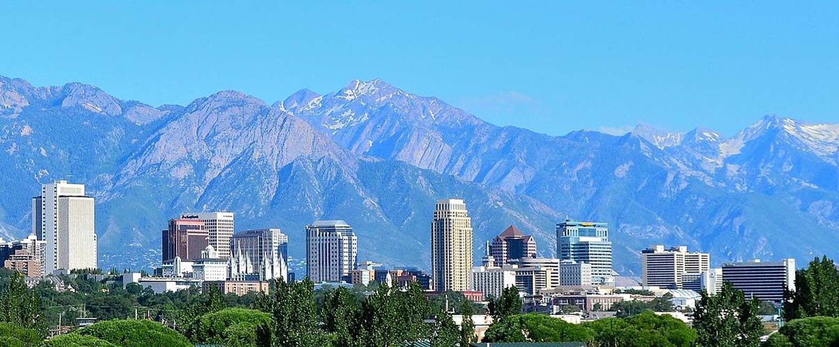
With a population of just under 200,000, SLC is Utah’s most populous city, with a metropolitan area estimated to have over one million residents. Views from SLC are spectacular with the snow-capped Wasatch Mountains to the east and the Oquirrh Mountains to the west.

Temple Square

Temple Square is the headquarters for Church of Jesus Christ of Latter Day Saints. The Church provides many wonderful performances on Temple Square, open to the public, regardless of religion.

This 35 acre three block area contains the principal buildings of the Church, statues and several memorials. On the grounds we first saw that there are two statues of Joseph and Hyrum Smith near the South Visitor Center. They were completed in 1911. We learned that the Smith brothers were the original religious leaders of the Church and that they were killed in Illinois by an anti-church mob. The Seagull Monument sits outside the Assembly Hall. Bronze seagulls sit on top of the monument. The monument is a reference to Mormon folklore where seagulls devoured insects that were destroying the first crops planted by Church pioneers in the Salt Lake Valley in 1848. www.templesquare.com

Salt Lake Temple

Salt Lake Temple
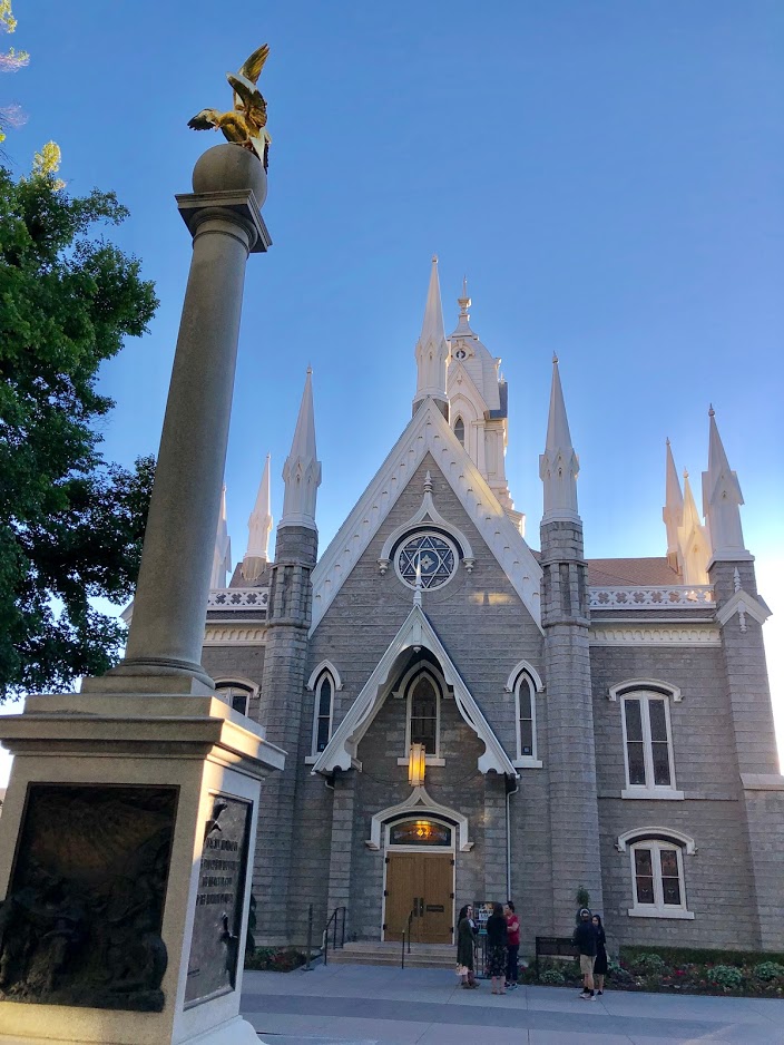
The beautiful Temple sits in the middle of Temple Square at 50 North West Temple Street and is a massive focal point of the square. Only members of the Church of Latter Day Saints are allowed entry into the Temple. Even though the building is not open to the public, the exterior is definitely worth viewing for its stunning exterior workmanship and sheer scale. Begun in 1853 when Brigham Young laid the cornerstone and completed in 1893, the neo-Gothic temple cost $4 million to build. Atop the 210-foot east tower is a gold leaf angel (Moroni) that Joseph Smith said visited him on numerous occasions. The worldwide icon was constructed by Mormon pioneers who sacrificed time, labor and material goods to create a symbol of their faith and devotion.

The temple is about to undergo major renovations later this year. The exterior contains six spires that reach towards the heavens. It is especially beautiful to view the Temple at night with its lights. Even the four sets of large solid oak Temple doors are decorated with religious symbols. This Temple is the largest Mormon temple based on its floor area.

Mormon Tabernacle Choir

Performances are complimentary. Tickets are not required for most performances. You can attend a two hour choir rehearsal which either takes place in the Tabernacle or the Conference Center, depending on the time of the year. Most rehearsals are on Thursdays at 7:30 p.m. The choir formed in the mid nineteenth century. The choir’s 360 volunteer singers are all members of the Church. Their collective voices are truly glorious.

 We attended a live broadcast of “Music and the Spoken Word.” The thirty minute weekly broadcast takes place on Sundays at 9:30 a.m. The program includes the renowned Choir and Orchestra. These performances are either in the Tabernacle or the Conference Center, again depending on the time of year. Tickets are normally not required and there is no fee for admission. This program is the world’s longest continuing network broadcast show and is available through live streaming on the internet, as well as on more than 2000 television, cable outlets and radio stations worldwide. We attended show number 4682. The first broadcast took place on July 15, 1929. www.mormontabernaclechoir.org.

Conference Center

We attended the Choir performance of “Music and the Spoken Word” in the Conference Center, which seats 21000. This show consisted of seven pieces, including an American folk hymn, music from West Side Story and several inspirational religious works. In addition, Lloyd Newell announced the spoken word portion of the broadcast, focusing on humility.

The 7708 pipe organ in the Conference Center was built from 2000 to 2003. This organ of the American Romantic style employs a symphonic tonal approach with the richness and warmth characteristic of English instruments. Although designed primarily to provide colorful and varied accompaniment, the organ also renders the solo repertoire beautifully.

After the performance, we attended a free one and one half hour tour of the massive Conference Center with one of the Church volunteers. Completed in 2000, the conference center is used for the Church’s national conferences. The tour is an opportunity to see an excellent collection of original art. One group of paintings focuses on scenes from the Book of Mormon by Arnold Friberg. The rooftop garden offers a panoramic view of the Salt Lake Valley. Other galleries feature portraits of current and past Church leaders.

An Organ Recital in the Tabernacle

The Salt Lake Tabernacle is located at 50 West North Temple Street. Completed in 1867, the Tabernacle seats 6500 under one of the world’s largest dome roofs without center support. The building has remarkable acoustics.

Thirty minute organ recitals are held daily at either Noon or 2 p.m. or at both times. There is no charge for admission. Temple Square supports a long-standing tradition of fine organ music with amazing organs. We attended a performance by guest organist Ikuko Weller. She first explained the wonderful acoustics in the Tabernacle by a demonstration showing how well we could hear the tearing of a newspaper or the dropping of a nail or pin without the use of a microphone. She then performed a series of seven pieces, two of which she arranged herself.

The organ in the Tabernacle was originally constructed by pioneer organ builder Joseph Ridges in the 1860s. It has been rebuilt and enlarged throughout the years, most notably in 1948. This organ is recognized by many as a quintessential example of the American Classic style of organ building, an eclectic approach. This huge organ contains 11,623 pipes and is said to be one of the finest organs in existence today.

Assembly Hall

We watched a portion of a flute recital in the Assembly Hall. Again there is no charge for admission. The hall seats about 1400. The hall’s exterior looks like a small gothic cathedral with 24 spires. We were particularly interested to see the Stars of David above each entrance. Constructed in 1877, the Assembly Hall is now primarily used for music concerts and as an overflow site for Church conferences.

The Assembly Hall organ was influenced by organs of the seventeenth and eighteenth centuries. Installed in 1983, this organ features mechanical key action, clear ensembles voiced on low wind pressure and a classically inspired tonal palette. The organ contains 3489 pipes.

Joseph Smith Memorial Building

Located at 15 East South Temple Street, this building is named for the first president of the Church. The building has been renovated, as it was operated as the Utah Hotel from 1911 to 1987. The elegant lobby contains decorative features such as marble columns, art glass and an impressive staircase. A Church volunteer took us on a short guided tour, which included the lobby and second floors. In 1993, the building reopened as a social center for the Church.

There is a small chapel within the building on the second floor. In the chapel, there is an organ with 2484 pipes built by a French-Canadian firm in 1993. This instrument is decidedly French in its tonal orientation, yet it has the versatility to render a wide range of repertoire.

The Smith building contains three separate restaurants. Short films are shown about the Church in a theater within the building.

Family History Library

We spent three hours in the fascinating genealogy center tracing our family trees with assistance from Church volunteers. In 2013, the Church opened the Family Search with the world’s largest amount of genealogy records. The search is free and there were plenty of computer terminals available to us.

Temple Square Tour

We attended a free 45 minute tour given by one of the Church missionaries. Church volunteers answer questions and explained the pioneers’ historic trip trek from Illinois to the Salt Lake Valley and why it took 40 years to build the Salt Lake Temple. It was largely due to the fact that the temple was built out of solid granite from a canyon 20 miles away from SLC. Under the leadership of Brigham Young, construction was halted until the railroad was built which dramatically reduced the delivery time for the materials. We briefly went inside several of the Temple Square buildings during this tour and viewed a number of the outdoor statutes.

Beyond Temple Square

Beehive House

Beehive sculpture
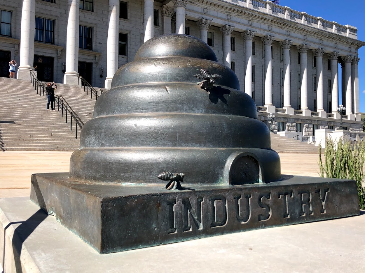
Just outside Temple Square, this house is located at 67 East Temple Street. The 1854 house is the restored official residence of Brigham Young, the second president of the Mormon Church. The house is decorated with period furnishings which show how the Young family lived in the 1850s. An image of a beehive, the state symbol of industry and a reference to Young’s worth ethic, sits on top of the house.

We attended a free 30 minute guided tour where we learned that Young served as Utah’s territorial governor. An interesting map in the house from this period shows how the Utah territory encompassed land well beyond its current state borders. Young helped establish Mormon pioneer settlements throughout the west.

Utah State Capitol

Utah State Capitol
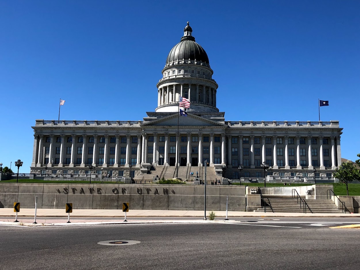
We made our way up SLC’s Capitol Hill to 350 North State Street for a self-guided tour of the Capitol building. The Capitol overlooks Salt Lake Valley from Capitol Hill. The Corinthian-style structure was built in 1916 of Georgia marble and Utah granite. The top consists of a huge copper-covered dome. Outside are several beehives representing the state symbol.

Inside the Capitol there are a main hall and rotunda with historical wall and ceiling murals. The State Reception Room is particularly attractive with its lavish furnishings and extensive use of gold leaf. We learned that the state was originally proposed by the Church of Latter Day Saints to be called Deseret, meaning honeybee. The Capitol building is open seven days per week, except for holidays.

At the conclusion of our five days in SLC, we determined that the city had some of the friendliest residents of any metropolitan area that we have visited. In particular, the missionaries and volunteers from the Church of Latter Day Saints provided us with extensive information about the Church without us feeling any obligation to become interested in conversion. SLC provides many more outstanding attractions without charge than most other U.S. cities.


If You Go:

Visitor’s Centers

LDS Visitor Centers are located in the northwest and southeast corners of Temple Square. Church volunteers are available within each visitor center to answer questions from the public about their religion.

Interactive exhibits in the North Visitor Center focus on the life, gospel and teachings of Jesus Christ. The starry dome of this center is highlighted by an eleven foot tall statue of Jesus Christ (called Christis). Interesting exhibits include biblical murals and a scale model of how Jerusalem appeared during the lifetime of Jesus.

Exhibits in the South Visitor Center focus on the importance of religion on families and on the Salt Lake Temple. Since the Temple is only open to members of the Church of Latter Day Saints, this is an opportunity to view a detailed model of the inside of the Temple and artifacts about the construction of the temple.

 Dining at Temple Square

We enjoyed an elegant dinner overlooking Temple Square at The Roof Restaurant. This restaurant offers a fine dining buffet on the tenth floor of the Joseph Smith Memorial Building. The buffet was extremely extensive and the views of the Temple Square buildings were dramatic as day turned into night.

We twice chose a lighter dinner at the Nauvoo Café in the lobby level of the Joseph Smith Memorial Building. The café offers sandwiches and salads in a more casual setting, without waiters. The sandwich breads were especially tasty. www.diningattemplesquare.com

Coffee Break

For a coffee/tea break, we stopped in at Nostalgia Café on 248 E. 100 South Street. This cute café is midway between the Capitol and Temple Square. In addition to drinks, a limited food menu is available, with both indoor and outdoor seating options.

Tips

Downtown streets are based on a grid system with Temple Square at the center. The light rail system (TRAX) provides three lines. Riding TRAX is free within the downtown area and there are several stops right next to Temple Square.

Pedestrian friendly City Creek Center at 50 Main Street includes a large foot court, stand-alone restaurants and about 100 upscale stores. The Center is decorated with a foliage lined creek that runs throughout the site. It is located directly across from Temple Square.

Lodging in the downtown near Temple Square makes sightseeing easier. The Grand America Hotel at 555 South Main Street is inspired by the charm of Europe’s classic hotels. The hotel was crafted from fine materials, such as Italian chandeliers, marble, West African woods and French tapestries. The rooms are extremely spacious and tasteful. The hotel offers several restaurant options, an outdoor pool and an extensive fitness center. The common areas are decorated with museum quality art and sculpture. Nearby, the less expensive Doubletree Suites at 110 West 600 South Street also provides spacious rooms, a nice fitness center and breakfast options.

Harmon’s grocery stores are located throughout SLC and provide an excellent alternative to restaurants. After our purchase, we had a meal just outside the store in one of their seating areas.


Salt Lake City Tour and Mormon Tabernacle Choir Performance

About the author:

Saul Schwartz lives in Alexandria, Virginia, just outside Washington, D.C. with his wife Fern. His travel articles have been published in newspapers including the Washington Post and the Jerusalem Post, as well as in on-line publications such as European Travel Magazine, Real Travel Adventures and Offbeat Travel. Saul loves to travel throughout the world and share his experiences through stories and pictures. He has written many articles on other subjects, but most focus upon his passion to travel!

Photo credits:

First photo by Garrett from Salt Lake City / CC BY

All other photos by Saul Schwartz

Tagged With: Salt Lake City Utah Filed Under: North America Travel

Abingdon, Virginia: History, Fables and Ghosts

Barter Theater Abingdon VA

by Patricia Apelt

After the bison and Native Americans had made their trails along the valley floor, early American pioneers followed. Their major route soon became known as The Great Valley Road, Boone’s Trace, The Great Road, The Wilderness Trail, then Route 11, and a part of it is now known as Main Street, Abingdon, Virginia.

In 1746, an expedition lead by Dr. Thomas Walker explored and surveyed the region and in 1769 a chance meeting of one of Dr. Walker’s friends, Joseph Martin, with Daniel Boone would change American history. Martin had accepted a challenge from Dr. Walker to form a settlement in what is now Powell Valley, Virginia. In 1773, a group led by Daniel Boone came by on their way to Kentucky. By this time, Boone had been leading groups of pioneers along this route west for many years.

In 1775 Judge Richard Henderson, a wealthy businessman and a group of his friends hired both Martin and Boone to work for the newly formed Transylvania Company. They intended to encourage settlement in the western states of Kentucky and Tennessee. Martin would serve as entry taker & civil leader in Powell Valley while Boone would serve as chief guide & scout and civil leader on the Kentucky side of the Cumberland Mountains. Boone led settlers from as far away as Pennsylvania through both the Cumberland Gap and Big Stone Gap, using The Wilderness Road for a large part of his route. It is estimated that approximately 2 to 300,000 hopeful settlers used the Wilderness Road in the years 1775 to 1810.

One of Daniel Boon’s favorite camping sites was along the creek flowing through parts of modern-day Abingdon. A legend tells us that while camped at this site, there was once an attack on Boone’s hunting dogs from wolves that lived in a cave nearby. He then started calling the area Wolf Hills and the emerging settlement was known by that name for several years. Wolf statues, carvings, and other artwork still turn up frequently in the town gift shops. A home was built on the property, but the wolf cave entrance has been preserved and can be seen in the back of the yard of the home.

“Black’s Fort was erected in the year 1776 on the lands of Capt. Joseph Black, on the west bank or near the west bank of what was then known as Eighteen Miles Creek, alias Castle’s Creek, by the settlers living in the vicinity, and about five hundred other settlers who had fled from their homes west of Abingdon upon the outbreak of the Indian War in 1776. It was one of those rude structures which the pioneers were accustomed to make for defense against the Indians, consisting of a few log cabins surrounded by a stockade.” The Cave House From an article written by C. ROBERT WEISFELD, Special to the Washington County News on Nov 13, 2015:

This fort was named the county seat of Washington County and was known by Black’s Fort until it and the surrounding settlement were incorporated in 1778. The fort itself and all of Wolf Hills was then re-named Abingdon in honor of First Lady Martha Washington’s ancestral home, Abingdon Parish in England.

The settlement had several groups of residents meeting as early as 1770 for religious services. These were usually held in individual homes, and some were served by circuit riders from more populated areas of the state. The first minister who came to Abingdon in 1773 was Parson Charles Cummings. He was known as “The Fightin’ Parson” because he always leaned his rifle against the pulpit while he led the service. Whether it was protection against the Indians or the wolves was never clear. His log cabin has been moved to the Sinking Spring Cemetery and preserved as it would have been in his lifetime. Several congregations grew over the years, including a Swendenborgian Church (New Jerusalem Church) in 1835, and the Catholic Villa Marie Academy of the Visitation (a girl’s school) in 1867. Today, there are United Methodist, Presbyterian, Episcopal, and Baptist churches, as well as other denominations.

As early as 1782 the town had several log houses, a log courthouse, jail, a blacksmith shop, and three taverns.

One of those taverns was built in 1779, has been well preserved, and is still used as a restaurant and meeting room today. Known simply as The Tavern, it has cozy fireplaces, low ceilings, narrow doorways, very good food, and it’s very own ghost.

Back when The Tavern was also an Inn for overnight guest such as Henry Clay, Louis Philippe, King of France; President Andrew Jackson; and Pierre Charles L’Enfant, designer of Washington D.C.

It also had a fair number of women that only came to be “Pleasure Doxies” for some of the travelers staying there. One of them was murdered by the man who hired her, then he promptly left town and was never caught. She continues to search all over the tavern looking for the man, but she also occasionally pinches customers on the rump, or knocks china to the floor, or floats around creating other mischief. The entire staff of The Tavern make sure they always work in twos, and especially never close up after hours alone. She can be mean.

Walking several blocks East on Main Street brings you to The Martha Washington Inn and Spa, known as “The Martha” to the locals. The Martha Washington Inn & Spa began life as the retirement home for General Robert Preston following his successes in the War of 1812. It was built in 1832 as a private residence for General Preston and Sarah Buchanan Preston and their nine children. Much of the architectural integrity of this historic landmark has been meticulously preserved for over a century and a half. The original brick residence still comprises the central structure of The Martha Washington Hotel and the original living room of the Preston family is now the main lobby of the hotel and the grand stairway and parlors are today much as they were in the 19th century.

In 1858 the Preston family home was purchased in order for the mansion to become an upscale college for young women. In honor of the first lady of our nation, the school was named Martha Washington College. The college operated for over 70 years through the Civil War and the Great Depression. In fact, it was during the Civil War that many of the Martha’s most intriguing ghost stories and legends evolved.

The “War Between the States” had a dramatic effect on the college. Schoolgirls became nurses and the beautiful grounds became training barracks for the Washington Mounted Rifles. Union and Confederate troops were involved in frequent skirmishes in and around the town with the College serving as a makeshift hospital for the wounded, both Confederate and Yankee. One of the nurses fell in love with a Union officer who was dying from his injuries. To help him feel better, she would often take her violin to his room and play for him. She still does.

There is often seen a fully saddled horse running over the grounds, looking for his master who died in a battle on the grounds. There are several other sightings of ghost in different areas of the building and upstairs in one wing, there is a blood spot on the floor that will not stay hidden.

Despite the devastating effects of the Civil War, the Martha Washington College survived. However, the Great Depression, typhoid fever and a declining enrollment eventually took its toll. The Martha was closed in 1932, standing idle for several years. For a period of time the facility was used to house actors and actresses appearing at the Barter Theatre. Patricia Neal, Ernest Borgnine, and Ned Beatty are but a few of the prominent actors who began their career here… all of whom have later returned to visit The Martha.

In 1935, The Martha Washington opened as a hotel and throughout the years has hosted many illustrious guests. Eleanor Roosevelt, President Harry Truman, Lady Bird Johnson, Jimmy Carter, and Elizabeth Taylor are counted among the many famous guests who have frequented the hotel.

In 1984, The United Company, representing a group of dedicated businessmen, purchased The Martha Washington and began a multi million-dollar renovation. Aware of this historic landmark’s importance to the town of Abingdon, the restoration was carefully designed to preserve and enhance much of its original splendor and architectural detail. In 1995, The Martha Washington Inn joined The Camberley Collection of fine historic properties.

Directly across Main Street from the Martha is the Barter Theatre. The man who began it was Robert H. Porterfield, (December 21, 1905 – October 28, 1971) from Saltville, Virginia, about 1-mile south of Abingdon. Growing up on a sheep farm, he soon realized he did not want to be a farmer, but did want to be an actor. He left home and went to New York City, but his timing was bad. Because it was The Great Depression, there was no work. After landing a bit part with a touring company, he came up with a great idea while riding a train with rest of the cast in the Midwest. Convincing some of his fellow very hungry and out of work friends to join him, they came back to Abingdon and began bartering produce from the farms and gardens of the region for the admission to a play. During this time, he continued to accept stage and film roles however, and his most prominent, credited film role was in the 1941 film Sargent York in which he portrayed Zeb Andrews, a local rival of the title character.

1933, Barter Theatre opened its doors, proclaiming “With vegetables you cannot sell, you can buy a good laugh.” The price of admission was 40 cents or equivalent amount of produce. Four out of five Depression-era theatregoers paid their way with vegetables, dairy products and livestock. To the surprise of many, all the seats for the first show were filled. The concept of trading “ham for Hamlet” caught on quickly. At the end of the first season, the Barter Company cleared $4.35 in cash, two barrels of jelly and a collective weight gain of over 300 pounds. Today, at least one performance a year celebrates the Barter heritage by accepting donations for an area food bank as the price of admission. Legion says that the very first ticket was paid for with a small pig. She was so cute the cast could not bring themselves to make bacon or hams from her. Instead, they would tie her out in front of the theater and her squeals would let people know a show was about to start. Porterfield was once quoted as saying “That one pig has done more for drama than any individual or institution.” (As printed in the book “WILL WORK FOR FOOD”, available from the Barter Theater Gift Shop.

The actors performing at the building were distracted not only by the occasional squealing pig or clucking hen, but noise from the town jail, which was located directly beneath the stage. The jail space was later used as a holding area for dogs suspected of rabies. It was eventually converted into dressing rooms for Barter actors.

Although being allowed to live in the now closed Martha Washington School for girls, the players used several stages during the early years, but finally found the home they have now. Built around 1830, it was intended to be the combined church for both a Methodist and a Baptist congregation. Before the construction was finished, the two groups decided they each needed their own building. It was purchased by the town of Abingdon and was used as an opera house and then the Town Hall. It is still owned by the town and the Barter still rents it from the town for $2.00 per year.

An interview with the current Producing Artistic Director Richard Rose brought out several interesting highlights. The Barter is the first true repertory theater in the country, was designated the State Theater for Virginia in 1941, with a residential acting company and technical crew of about 130 full-time employees and about the same number of part-timers. Most of their audience consists of return patrons from within a 150-mile radius. The Barter was at the forefront of “color-blind casting”, and have continued to do so. There are apprenticeships available for technical students, the Barter has a thriving children’s’ theater, and sponsors the annual Appalachian Festival of Plays and Playwrights to encourage new writers. They often include some of these plays in their regular lineup.

Mr. Rose also talked about the ghost of the Barter. Before the renovation of the theater in 1995, a balcony ran down both sides of the upstairs almost to the stage. Several actors over the years talked of seeing Robert Porterfield, always dressed in a white suit, sitting in a seat on the front row of that balcony every opening night. Or he would be seen at other times looking out of one of the front windows. After the renovation of the theater, he has not been seen.

While interesting, there is so much more than ghosts and legends in Abingdon, Virginia. It is the beginning of the 34.3 mile Virginia Creeper Trail and the Muster Grounds for the Overmountain Men-1000 volunteers who helped turn the tide in our favor during the American Revolution. The Muster Grounds is also the trail head for the 330-mile Overmountain Victory National Historic Trail. If you do not care for hiking and/or biking, there are numerous historic places to visit, such as the Sinking Spring Cemetery, the William King Museum of Art, White’s Mill, and a self-guided walking tour of the downtown Historic District. There are numerous places to eat and several nearby motels, hotels, and inns for overnight stays. Be sure to check out the Abingdon Visitor Center/Hassinger House on Cummings Street. They have a very helpful, courteous staff that can offer tons of information about the area and the people.

Abingdon, Virginia is a wonderful small town with a big heart. A great place to visit or maybe even become a “local.” You would be welcomed.

If you go:

www.triphobo.com/places/abingdon-virginia-united-states/things-to-do?utm_source=5412&utm_medium=123&utm_campaign=dsawittractttdcaout&gclid=EAIaIQobChMIzInr8tKc5gIVoxx9Ch04AQPbEAAYASAAEgLOfPD_BwE

www.mapquest.com/us/virginia/abingdon-va-282039081


Day Trip to Jack Daniels Distillery and Lynchburg with Lunch

About the author:

Patricia Apelt has been an avid reader since she was first able to hold a book in her hands. She is now writing them herself, with two novels already published and a third is ‘a work in progress’. She is also exploring the world of Travel Writer and enjoying it very much. She has five grown children and lives with her husband and three dogs in Poquoson, Virginia. www.patriciaapelt-author-connections.com

Photo credit: RebelAt (talk) (Uploads) / Public domain


Tagged With: Abingdon Virginia Filed Under: North America Travel

Cocoa Beach Florida: Sun, Swamp and Space

Kennedy space center

by Susmita Sengupta

The massive concrete building loomed in front of us and a shiver of excitement ran through me. Soon we would be stepping into one of the most electrifying living museums, a place where scientists have worked consistently to send people and cargo to space. Yes, I am talking about NASA and John F. Kennedy Space Center, an awe-inspiring place to visit irrespective of whether you are a space enthusiast or not. A few years ago, my family and I were vacationing in Florida, the Space Coast to be precise and we were in Cocoa Beach.

We drove into Cocoa Beach from Orlando, home to Disneyworld, the premium tourist destination for people from all over the world. Close to 48 million visitors traipse through this wonderland each year. Not many people venture to Kennedy Space Center located on Merritt Island, near Cocoa Beach, a mere one hour and few minutes away by road from Disneyworld. Only about 2 million people visit the Kennedy Space Center annually.

Kennedy space center vehicle buildingOur visit to the Kennedy Space Center started at the Visitors Complex, which in itself is a space to behold. At the U.S. Astronaut Hall of Fame, it was inspiring to see the life and achievements of all the astronauts who have traveled to the moon and space like such luminaries as Neil Armstrong, Buzz Aldrin, John Glenn and the first woman member Sally Ride. It includes space shuttle astronauts connected with Apollo – Soyuz, Mercury, Skylab, Apollo and other such programs. Being inducted into the Hall of Fame is an ongoing program and every year astronauts are added to the group in a ceremony. I found out that in order to be inducted, the astronauts have to be a NASA trained specialist, commander, or pilot and has to have orbited the earth at least once.

The Rocket Garden has an outdoor display of early rockets from the Mercury, Gemini and Apollo Space programs. The line was long at the Shuttle Launch Experience, where the braver visitors can feel the simulation of a real launch traveling at 17,500 mph on their way to orbit the earth. There is also an Astronaut Encounter event where one can meet pilots, commanders, astronauts and payload specialists in a live meet and greet session.

We decided to take the Kennedy Space Center Bus Tour, truly a highlight of visiting this complex. Although there are two bus tours, it is quite impossible to do both. We decided on the one that linked up more closely with our own interests. This behind the scenes tour takes visitors to restricted launch sites and spaceflight facilities, both historic and working. About 40 minutes long, the bus winds its way through the NASA complex, passing by the large, concrete building known as the Vehicle Assembly Building, the site where the rockets are constructed, the launch facilities known as Launch Complex 39, where we were delighted to see a shuttle being readied for a launch.

Another highpoint was when we walked through the preparation and construction facilities for the International Space Station. The Space Station, which orbits the earth about every 90 minutes, has been in space since 1998 and has been continuously occupied by astronauts of member countries since 2000. Astronauts stay over for around six months doing research and experiments on impacts on health due to long-term space stays. Because it is gargantuan in size, the station has been assembled over the years in parts and transported to space using shuttles and other rocket flights. We were awed at the feats of human technology and engineering, marveling at the size of the constructions and wondered how such massive objects get transported into space.

The bus tour concludes at the Apollo/Saturn V Center, which is dedicated to a vital point in the American space program, namely the landing of man on the Moon. Here we entered the era of Project Apollo, touring exhibits and viewing major milestones and moments connected to moon landings. I stared in amazement along with other visitors at the colossal 363-foot Saturn V rocket, the largest rocket to fly astronauts to the moon and back. The Firing Room Theater is where I thrillingly experienced the reenactment of the launching in December 1968 of the Saturn V moon rocket and the countdown for the spacecraft Apollo 8 carrying the first crew to orbit the moon, all of it done using the actual consoles used for the mission. While at the Lunar Theater, it was wonderful to see a short movie on the historic July 1969 Apollo 11 Moon landing.

Having spent almost an entire day at the Kennedy Space Center, we decided to make some time for other attractions in the area. First up was a boat tour to see alligators. This meant that we would be experiencing a first time ride on an airboat, the characteristic method for gator viewing in Florida’s swampy marshlands. We reached Lone Cabbage Fish Camp, about a half hour by road from our hotel in Cocoa Beach and a fixture in the area since the 1940s. The place started out as a fishing outpost but is now quite overrun with tourists seeking gator views. Soon after our ticket purchases, we boarded the airboat, a flat-bottomed vessel with a huge caged propeller fan in the back. We sat on seats reminiscent of park benches and then we received hearing protection headphones to wear for the trip, as the propellers get quite noisy. Soon the airboat zipped on its way, skimming across the St. John’s River, the longest river in Florida. Around us were the grassy marsh, swamps and wetlands with breathtaking views. Before we knew it, the captain slowed down the boat to cut the noise and I had my first glimpse of an enormous alligator, resting on the marsh and soaking in the sun. It was not long before we saw more alligators as the boat now slowly glided along the river. There were water birds in the marshes, but although the brochure promised views of cows, bald eagles and wild hogs, we did not see any. It is a short ride of around 30 minutes and soon we were back at the dock, ready for our next activity of the vacation.

airboatsMy daughter decided that we should spend at least a few hours on the beach and so we trooped back to our hotel area to enjoy the sun and sand of Cocoa Beach. This is an Atlantic beach, almost 70 miles of it and the water was surprisingly calm. I knew that many people preferred going to the Gulf Coast beaches due to much calmer waters and an abundance of seashells. The Atlantic beaches were preferred by surfers due to high waves. Cocoa Beach is deemed to be the surfing mecca of Florida, there is a profusion of available surfing lessons, and the world’s largest surf shop is located here. But then, we are not a surfing family and we were glad simply to wade in the waters and enjoy the vista of the ocean.

And in the end how could we be different from other tourists? Giving in to our impulses and making our daughter happy in the process, we decided to visit one kingdom of Disneyworld. Keeping the theme somewhat intact, we went to Epcot, the only theme park we had missed on an earlier trip to Orlando. The “Experimental Prototype Community of Tomorrow” or Epcot was the second of the Disney theme parks and it opened in 1982. It was envisioned as a planned living community highlighting technological innovation but those plans fell to the wayside after the death of Walt Disney. Instead, the focus was kept on modern innovation through its attractions and an addition of world nation showcase.

Epcot sphereEntering the park, we immediately viewed the iconic geodesic sphere, almost a symbol for Epcot. The original geodesic dome was the brainchild of Buckminster Fuller and it was first displayed as Biosphere at the Montreal Expo in 1967. Fuller conceived the sphere to house humans in need of survival but the idea never really caught on due to builders not being skilled enough to build such structures.

Then in the 1960s, along came Walt Disney with his vision for a utopian city, perhaps with a geodesic dome. Although his dream was never truly realized as he died before knowing about the Montreal Expo and Epcot became an entertainment ground, the geodesic sphere, now named Spaceship Earth became an immediate attraction at its opening. This theme park is different from the other Disney parks in that the attractions are geared towards science and nature and thus was considered to not be very child friendly. Nevertheless, we as a family enjoyed doing the tour of the greenhouses where a variety of plants and vegetables are grown. Equally inventive and wonderful were the visits to one of the largest salt-water aquarium and the ride along the wonders of the world. Our visit to Epcot was capped off by the signature fireworks display that is held every evening when thunderous but dazzling fireworks and lasers light up the nighttime skies.

Florida’s Space Coast turned out to be an ideal vacation getaway with something to suit everyone’s interest and taste.

If You Go:

For more information:

visitspacecoast.com

kennedyspacecenter.com

twisterairboatrides.com


Kennedy Space Center at Cape Canaveral: Ultimate Space Pass

About the author:

Susmita Sengupta, an architect by background, is a freelance writer who loves to travel. She and her family have traveled to various parts of the USA, Canada, Europe, the Caribbean, Middle East, Southeast Asia and India.

Kennedy Space Center Visitor Visitor Complex photo by Gzzz under the Creative Commons Attribution-Share Alike 4.0 International license.

All other photos by Susmita Sengupta.

  • The Vehicle Assembly Building at Kennedy Space Center
  • Touring a room of rockets
  • The massive Saturn V Center rocket
  • Airboats readying up for alligator viewing trip
  • The iconic Geodesic Sphere or Spaceship Earth at Epcot


Kennedy Space Center Day Tour with Airboat Ride from Orlando


Tagged With: Florida travel, Kennedy Space Center Filed Under: North America Travel

Kariya Park, Mississauga, Ontario: History, Friendship And Beauty Of The Nature

kariya park mississauga

by Sonja Slijepcevic

In the city centre of Mississauga, Ontario, a city which is part of the Greater Toronto Area, there is a “secret” garden, which cherishes the part of the city of Kariya, Japan. Mississauga and Kariya have been twin cities since 1981 (38 years). Many don’t know that just a step away from the busy city centre and well-known Square One Mall, nestled among tall high-rises, is the Kariya Park, that brings a little peace and calmness to the buzzing city life. The idea of the Japanese gardens is to “delight the senses and challenge the soul” as well as to create the sense of balance and aesthetics.

cherry blossomsIn Spring, which here in Southern Ontario usually comes in late April or early May, you may enter a different world and be embraced with lush cherry blossoms, birds singing, the calming flow of the wild ducks in the pond, squirrels playing in trees or chasing each other in the grass. Even visitors unconsciously start whispering when entering this oasis of calmness. You walk or sit on a bench and just surrender to the serenity and give yourself the wonderful gift of a quite moment.

friendship statueAmong the trees and bushes you will find several nice stone sculptures which makes you wonder who created these beauties. I have always been drawn and charmed with particularly one sculpture (The statue of Friendship), a boy and a girl embraced in a sweet hug with joy on their faces. Every time I see them, they just brighten my day.

This “secret” garden, a piece of Japanese culture and creativity is a gift of friendship from Kariya to Mississauga. It was completed in 1992 and ever since warms the hearts of Mississauga’s residents and visitors who discover the park. So, leave your shopping bags loaded with gifts and souvenirs in the car and walk to this centre of slow pace and enjoyable sounds.

Friendship bellWalking on the path by the pond, you will come to the Pavilion, which looks toward the pond and the exterior Zen garden. The two sections of the Pavilion represent the two cities, united in the centre with the Friendship Bell. The Friendship Bell was partially sponsored by the Main Street Ontario funding program and cast in Japan. It is rung on ceremonial occasions. The bronze bell was installed for the Phase II Opening Ceremonies on July 7, 2001. The Friendship Bell has images of iris flowers, which are the official flowers of Kariya city, Canadian maple leaf as well as an inscription which reads: “By welcoming the new century this bell is produced as a symbol of everlasting friendship between the City of Mississauga and the City of Kariya. It is our sincere prayer that the toll of this bell will spread peace and happiness over the world of our society. July 7, 2001.”

While wandering through the park, think about others just like you, on the other side of the world in Kariya city in Japan, who are walking along the garden paths discovering the beautiful Mississauga Garden with a small-scale replica of Mississauga’s city hall and the clock tower surrounded with colourful blossoming flowers.

These two city gardens are the symbols of blossoming friendship between two cities and their residents. These are the places where they connect, where they learn about each other and look further in to the future. Every year there are more events, meetings, student exchanges where citizens of both cities become closer and give a little contribution to the wish of total world peace and friendship.

The Friendship Bell is of great significance. The iris on the bell represents Kariya, and the Canadian maple leaf symbolizes Mississauga.

Custom Enamel Pins are inspired by the Friendship Bell, and these iconic elements on the bell are cleverly integrated.

When people wear this pin, it is like hearing the long ringing of the Friendship Bell, which is a prayer for peace and happiness, and a firm protection of the eternal friendship between the two cities. In various cultural exchange activities and student exchange programs, such custom enamel pins are distributed as souvenirs, which can deepen people’s cherished of this friendship.

This year, as several before, cherry blossom tree fans came from Toronto and nearby cities or visitors from far away to specifically enjoy and photograph the cherry blossom, the symbol of Japanese Spring. Some of them came to take memorable wedding photos among the cherry flowers.

Next time when you land at the Toronto International Airport (which is actually in Mississauga) don’t forget to visit the Kariya Park. Just a few minutes spent here will re-charge your batteries and give a new boost to your busy life.

So, how did all this start? In the period after the Second World War and the “cold war” in 1960s there was an initiative and movement supported by mayors and residents to start connecting cities around the world, to extend the hands of friendship and make our world a better place to live. Mississauga’s twin city Kariya is located between the cities of Kyoto and Tokyo on the island Honshu. It has approximately 150,000 people and it is known for the auto industry and agriculture. The Mississauga Park in Kariya was opened in 2001 to celebrate the 20th anniversary of the cities twinning. “The Water Road” sculpture in the park, a work by the artist John McEwen, presents a bear in a canoe, a symbol of Canadian history and culture carried from the past to the future. The City of Mississauga, Canada is a vibrant city with a population of over 700,000 situated on the shores of Lake Ontario. The city’s motto is “Leading Today for Tomorrow.” Many Fortune 500 companies have their headquarters in Mississauga, and the city’s strongest industries are banking and finance, pharmaceuticals, electronics and computers, aerospace and transportation.


If You Go:

The Park address is Kariya Drive (across the Square One Mall), Mississauga, Ontario.
Park is open to the public seven days a week from 7:00 am to 9:00 pm.
Dogs and other pets are not allowed to the garden.

About the author:

Sonja Slijepcevic is a freelance travel writer and photographer, a member of the International Travel Writers and Photographers Alliance (ITWPA), who for years has been combining her love of travel, passion for photography and professional career in the project management field. She likes meeting people from different cultures and backgrounds, enjoys history and art, and likes to write about these experiences. Some of her photography and articles have been published in different Canadian magazines and newspapers such as Travel Thru History or Wanderous Affair. She was born in the capital city of Croatia, Zagreb and has been living in Canada for 26 years.

First photo by Nayuki  licensed under Creative Commons Attribution 2.0 Generic (CC BY 2.0)

All other photos by Sonja Silijepcevic

Tagged With: kariya park, mississauga Filed Under: North America Travel

Balankanchè, Altar of the Tiger Priest in Yucatan, Mexico

Chichen Itza pyramid

by George Fery

Caves are central to world cultures, used by humans from the dawn of time. They are associated with powerful natural forces believed to be the dwelling places of benevolent and malevolent deities, protectors and disruptors of communities, families and individuals’ lives.

The Balankanchè cave is located 2.5mi/3.9Km southwest of Chichén Itzà’s archaeological site, near the town of Pistè. Its proximity to this major pre-Columbian site underlines the fact that Balankanchè was an integral part of Chichén Itzà for religious rituals and ceremonies.

The cave was called the “Throne of the Tiger Priest” by E. Willis Andrews, in his 1970 archaeological field report. Among known caves in the Maya lowlands, Balankanchè has received less attention than it deserves. Its significance can fully be understood in contrast to the monumental secular site above ground. The interaction between the surface elements and those of the cave, give us an unusual light on the life of the ancient metropolis.

The Itzaes were Maya-Chontales or Putunes that controlled the trade routes around the Yucatán peninsula. They occupied the island of Cozumel and from there, crossed over to the peninsula reaching Chichén Itzá in 918AD. A second group of migrant-soldiers, mixed with nahualtl speaking Toltecs, reached Chichén around 987AD, introducing the cult to Quetzalcoatl from Tula (Hidalgo). They established a military dynasty that ruled the northern peninsula (Thompson (1954, 1966, 1970), R. Piña Chán (1980). The record is in agreement with the book Chilam Balam of Chumayel that refers to two groups of invaders as the “little descent” (918AD) and the “big descent” (987AD).


A recently discovered a cenote (sink hole) 15ft/4.6m below the base of Kukulcán pyramid (aka El Castillo), called the Balamkú cave, will shed new light on beliefs and rituals of the Toltec period. The shrine, like Balankanchè, was dedicated to the Toltec religious figure Quetzalcoatl, the Mayas called Kukulcán.

The Toltec invaders, from the central plateau of Mexico and their history at Chichèn, spans from the Late to the Terminal Classic (987-1250AD). Its large Sacred Cenote, aka Well of Sacrifice, located at the end of the 600ft /180m sacbe or “white road”, the link to the Kukulcán pyramid, was believed to be the main gateway to the underworld and Cha’ak’s home from pre-Toltec times. This cenote was strictly dedicated to religious rituals and ceremonies involving human sacrifice, as remains found testify. The Xtoloc (iguana) in the city, among other cenotes in the vicinity, supplied water to the community. Of note however, is that all cenotes were at times used for religious rituals.

Balankanchè’s importance was first noted in 1958 by Josè Humberto Gómez who had explored the cave over ten years. He eventually discovered what seemed to be a false section of one of the walls. On examination, he realized it was made of crude masonry sealed with mortar covering a small access chamber. Previous archaeological expeditions had come within feet of the wall, probably sealed during the later part of Toltec occupation, not realizing what lay beyond.

Entering the chambers in 1959, researchers found a large number of ceremonial ceramics, beyond two crude stone walls 98.5ft/30m and 361ft/110m respectively from the entrance, and carved limestone effigy censers, as well as mini-metates (grinding stones) set into cavities in the cave’s complex stalagmitic formation, as well as simply laid on the floor. They were among many similar artifacts found in the cave.

Archaeologists believe that Balankanchè’s “first tenant” was probably Cha’ak, a Maya agrarian deity with mythological attributes akin to Tlaloc, the Lord of the Third Sun in Toltec mythology, whose roots go back to Teotihuacàn and, farther in time, to Olmec cosmology.

 The Toltec invasion from central Mexico (987AD), explains the presence of Tlaloc ceramics and Xipe Totec, the enigmatic life-death-rebirth deity carved limestone censers, the only artifacts found in the cave. The total eradication of Cha’ak representations, underline the proscription of the old god by the new one. The Toltec invaders settled in power centers and towns, while traditional Maya-Yucatec’s Cha’ak and deities remained unchanged in the countryside. Balankanchè “second tenant” would be Tlaloc, the Toltec goggle-eye deity of rain, storm, lightning and thunder. The deity that came from Tula on the central plateau of Mexico, is associated with caves, cenotes, springs and mountain tops—all believed to be guardians and holders of rain and maize, in past and present Mesoamerican mythologies.

Balankanche mapTlaloc and Xipe Totec censers found in the cave are made of ceramic and limestone respectively. They represent deities that reached the Yucatán peninsula with the Toltec invaders. While relatively little is known about pre-Toltec deities and fertility gods of the Yucatán, the record indicate that the cave may have been the focus of a folk cult (Edward B. Kurjack, 2006 – personal communication).

Balankanchè’s surface mounds and other structural remains are seen scattered on the site above ground. The cave entrance, in the center of the complex, was surrounded by a 115 ft/35mt circular tulum or defensive wall, 12ft/4m wide at the base and raised 4ft/1.3m above the rock base. It was surmounted by a 6ft/2m enclosure made of perishable material that is now lost to time. The reason for such a strong defensive wall is not known and may pre-date Toltec’s arrival.

The entrance today is located at the center of the circular walled area. It may not have been the location of the original entrance, nor the only access. From ground level, steps take the modern visitor down to a depth of 30ft/9m, then the corridor branches off.

Balankanche entranceThe accessible part of the cave is made up of more than a mile of passageways that vary considerably in shape and size, from broad and flat (as much as 30ft/9m wide and 15ft/5m high), to narrow crawling spaces. Other passageways are no longer passable. The cave is divided into six groups, one of them, now closed may have been the other ancient access to the cave.

The corridors and steps for visitors are well built, lit, maintained, and easily walkable, but there are limitations to admission to the cave. For lack of limited ventilation in the corridors, senior persons, health conditions (pulmonary and coronary in particular), or physical impediment may be prohibited entrance. Sections of the main corridors cannot be visited; some reach the water table at 70ft/22m beneath the surface in at least four places. Water depth vary with seasonal rains and entrance to the cave is sometimes suspended after sudden downpours. There is another corridor under the main one, half submerged and very difficult of access, but for professional cave archaeologists.

balankanche main chamberThe cave’s main chamber is Group.I, a huge and impressive circular room with thousands of stalactites covering the ceiling. The floor, naturally raised as a mound, holds massive twin limestone columns made of both stalactites and stalagmites linked at the center, in the shape of a massive tree trunk.

The cave is a strikingly beautiful work of nature; the high place of a culture that consigned its myths and beliefs in its gods and deities to the mineral world. The central column is a reminder of the trunk of the Ceiba, the mythological Wakah Chan, the “Tree of Life” whose branches reach to the heavens, while its roots are sunk deep into the underworld. The veneration of the “Altar of the Tiger Priest”, can only be understood in the context of the vision of a dual perception of life.

This impressive sanctuary created by nature but conceived by man as an altar for the gods was walled toward the end of the Terminal Classic phase (850-1000AD) The ceramics on the “altar” are representatives of two non-Maya deities from the central plateau of Mexico. Twentynine large Tlaloc-effigy biconical censers and Xipe Totec carved limestone censers were found on the mound of the altar, together with mini-metates (stone grinders) and manos, miniature ceramic plates, bowls and other offerings, dated from the Florescent (625-800AD) to the Modified Florescent (800-950AD) phases. Female Maya deities, Chak’Chel and Ix’Chel, patrons of childbirth, sexuality and fertility, are present in the cave.

Altar of Pristine WatersGroup.II,, is referred to as the “Altar of the Pristine Waters” and, to this day, holds a special place in Maya rituals; it is called the “store room” by archaeologists. At the foot of the limestone columns were placed ceramic urns, set there to collect virgin water or zuhuy’ha in Yucatec. Water drips from the stalactites above and is believed to be the most sacred water in Maya rituals, since it is collected from stalactites, the “nipples of the earth”. It is sanctified because it never touches the ground and, being transferred directly from Nature (the rock) to Culture (the manmade urns), acquire the highest ritual value, and is still practiced in today’s rituals.

The importance of the rain god Cha’ak, and its multiple representations in Mesoamerican cosmology, essentially revolve around a simple word: water. The peninsula lies nineteen degrees north of the equator. Its geographical location and Maya lands further south enjoy only two seasons: dry and wet. If the rains do not come on time, crops are short or fail entirely. Famine may then endure with its retinue of malevolent deities and social disruptions together with hunger, and the fear of tomorrow.

On the underground lakeshore is Group.IIIa with a peculiar arrangement of small ceramic censers, plates and small spindle whorls, as well as stone mini metates, and manos; the largest number of offerings in Group.III. How and why they were displayed is not known, nor the reason for the assemblage and their respective numbers. Their small sizes are particular to Tlaloc offerings; their purpose, point to their use by small children. Of note is the fact that their display today was set by archaeologists, since we do not know of their disposition in ancient times.

Balankanche offeringsEthnographic accounts throughout Mesoamerica document miniature objects as offerings, often associated with rain-making rituals. Young children, particularly girls were favored by Tlaloc, god of rain and thunder. The presence of spindle whorls underlines the symbolic significance of weaving that has been documented to be associated with females and Chak’Chel (great or red rainbow), the aged goddess of curing and childbirth in Classic times. She is also known as Ix Chel (lady rainbow), from her shrines on the islands of Isla Mujeres and Cozumel. To the Maya, rainbows came from the underworld and were dreaded omens of illness and death (Sharer & Traxler, 1994 :735).

Group.IIIb is referred to as the “Waterway” now mostly flooded, because it is located close to the top of the water table. The underground lake extends about 115ft/35m from the shore, then dips below the ceiling of the cave and turns northeast for another 330ft/100m, before rising again above the water table reaching Group.IV, not accessible today. Investigators found ceramics and stone censers in the water and on limestone outcrops. At the end of the elongated lake, is a chamber that seems to be the limit of human penetration in this direction. The average depth is 5ft/1.5mt, with about half that depth in mud (Andrews, 1970:12-13).

On the muddy floor of the waterway were scattered offerings, such as Tlaloc effigy censers, studded censers and a variety of pottery offerings, with a distribution densest near the shore. According to Andrews (1970), at least four passages lead to underground water pools, the main reasons for the cave’s long period of use for this area, where the water table lay 65-76ft/20-23m below the surface.

Long before Tlaloc, the sacred cave was used for the same purposes by its predecessor, the Maya Cha’ak. The cave was “returned” to the Maya deity during a complex and elaborate ritual ceremony, the “Reverent Message to the Lords” that started on the early hours of October 13, 1959, and lasted 3 days and nights. But not before Maya h’men or shamans from the vicinity, through ancient rituals and offerings pacified the deities in the cave, the Yum Balames, to safely allow non-Maya to enter the hallowed precinct (Andrews, 1970:72).

Caves were believed to be the birthplace where humans were born and set forth on earth at the beginning of time, and where they would return at the end of their days. Ancestors dwelling in caves are trusted to interact with the World Above. No less than the sacred earth, caves are believed to be the meeting grounds between humans and the divine.


Private Tour: Chichen Itza Aboard Deluxe Van with Lunch

References:

Balankanche, throne of the tiger priest – E. Willys
Andrews.IV – MARI-Middle American Research Institute at Tulane University, New Orleans, LA, 1970
The Ancient Maya – Sharer & Traxler, Standford U. Press, Stanford, CA, 1994:735.
Chichén Itzá – Román Piña Chan, Fondo de Cultura Econòmica, Mexico,1980
Maya History and Religion – J. Eric Thompson, University of Oklahoma Press, 1970


Private Tour: Chichen Itza, Ek Balam Cenote, and Tequila Factory

About the author:

Freelance writer-photographer, George’s mayaworldimages.com focus on the photography of pre-Columbian archaeological sites in Mexico and the Americas. The other site georgefery.com is concerned with history and travel stories that address a number of topics, from history to day living in various countries and cultures, food, architecture and people.

Long-Form articles in georgefery.com are dedicated to ongoing research papers on Maya and other cultures of the Americas. Fellow member of the Institute of Maya Studies, Miami, FL instituteofmayastudies.org and The Royal Geographical Society, London, U.K. rgs.org . Also a member in good standing with the Maya Exploration Center, Austin, TX mayaexploration.org . the Dallas Museum of Art, Dallas, TX dma.org , and the Archaeological Institute of America, Boston, MA archaeological.org Contact: George Fery – 5200 Keller Springs Road, Apt. 1511, Dallas, Texas 75248 – T. (786) 501 9692 – gfery.43@gmail.com and hello@georgefery.com

All photos by George Fery


Private Tour Chichen Itza, Cenote and Unique Mayan Ritual in Temazcal

Tagged With: Balankanche cave, chichen itza tours, mexico travel, yucatan attractions Filed Under: North America Travel

  • « Previous Page
  • 1
  • …
  • 33
  • 34
  • 35
  • 36
  • 37
  • …
  • 72
  • Next Page »

MORE TRAVEL STORIES:

A Comprehensive Guide About Norway Residence Permit Requirements

Uncover Indoor Gems in Pigeon Forge Perfect for Rainy Days

Pioneer History Comes Alive at 5 Heritage Sites in Champoeg, Oregon

Egypt: Pyramid Power

6 Strange Places You Can Only Find in Australia

“Do-It-Yourself” Angels and Demons Tour of Rome

Roman Pompeii: Suspended in Time

Simplicity That Stuns: Your Essential Travel Wardrobe for India


SEARCH

DESTINATIONS

  • Africa Travel
  • Antarctica travel
  • Asia Travel
  • Australia travel
  • Caribbean Travel
  • Central America Travel
  • Europe Travel
  • Middle East Travel
  • North America Travel
  • Oceania Travel
  • South America Travel
  • Travel History
  • Travel News
  • UK Travel
  • Uncategorized
  • World Travel
facebook
Best Travel Blogs - OnToplist.com

Copyright © 2026 Cedar Cottage Marketing | About Us | Contact | Privacy Policy | Terms & Conditions | Copyright Notice | Log in