by Darlene Foster
I searched for an ideal location for a three generation get-away, a place where could we go that would cater to a thirty something daughter, a seventy something mom and me, somewhere in between. I had heard good things about Sedona, Arizona and since it was on my list of places to visit, I decided to take my two favourite women there for a week. It proved to be the perfect choice.
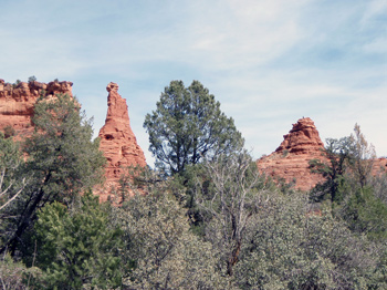
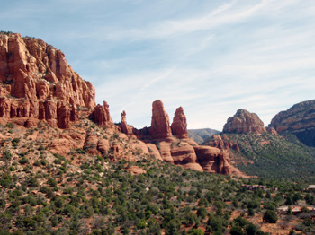
Upon arrival, we are mesmerized by the magical red rock formations everywhere we look. Sedona, named after the first post mistress, is nestled in the Oak Creek Valley surrounded by sandstone shapes resembling their names. Monikers such as Cathedral Rock, Bell Rock, and Coffee Pot Rock. There is even a Snoopy Rock; a configuration that looks like the adorable cartoon character lying on top of his doghouse, with Woodstock perched on his nose.
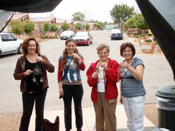
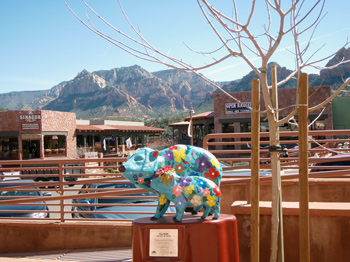 The town provides a relaxed atmosphere with a creative flair. The soothing terracotta buildings blend in perfectly with the surroundings. The town centre displays samples of local paintings, sculptures and carvings. We enjoy the delightful mama javalina (a wild pig-like animal) sculptures in colourful print dresses, with their babies beside them. Wandering the streets of Sedona is like walking through an outdoor art gallery. There are many impressive inside galleries to visit, such as the Sedona Arts Centre. The numerous shops make it difficult not to come away with a special treasure to take home. I can´t resist purchasing a Snoopy Rock T-shirt for my grandson.
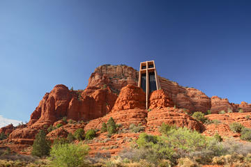
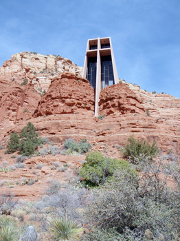 The Church of the Holly Cross built high amongst the bluffs overlooking Sedona is a remarkable work of art. Designed by architect and sculptor Marguerite Brunswig Staude in memory of her parents, it was completed in 1956 and is open to people of all faiths. The view through the picture window, divided in four by an enormous cross, is spectacular. Outside the chapel are perfect photographic opportunities of the area’s stunning rock formations and the valley 200 feet below. An appropriate configuration nearby resembles the Madonna and child and surrounding it are three rock figures that remind you of praying nuns.
We take an inexpensive trolley tour to search out places not easily accessible by foot. The tour takes us to Boynton Canyon, a place sacred to the Native Indians. As we drive through the Coconino National Forest, our informative guide, Jack, points out the plant life of the harsh high desert terrain including agave, sycamore trees, ponderosa pines, alligator juniper, Utah juniper, and pinion pines (from which pine nuts come). He brings our attention to a high flat topped area called the Doe Mesa where female dear go to have their babies; the high mesa providing natural protection for the mothers and newborn. He cautions walking around as there are over 20 varieties of rattle snakes in the area. When we stop to take pictures, only a few of us are brave enough to get off the bus.
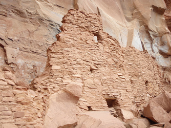 On another day we visit the Palatki Red Cliffs Heritage Site to view pictographs and visit cliff dwellings built by the Sinagua Indians 900 years ago. Walking sticks are provided to get to the sites situated on the steep sides of the cliffs. Due to their location, the well preserved dwellings have not been touched by rain. The masonry blends well with the red sandstone providing security to the dwellers. No one knows what eventually happened to the inhabitants, but the sense of family can be felt as we peer into the rooms where people carried out their day to day activities. The finger prints remain, if not to the human eye. This is not a place to wear white as I soon learn. The iron oxide that makes the sandstone red leaves evidence of your visit. We are also careful to dodge the Costco sized prickly-pear cacti that are everywhere.

 Sedona has a unique blend of history and new ageism. The area is well known for the energy originating from its many vortexes. My daughter finds the vortex sights fascinating. She visits the Boynton Canyon vortex and discovers a positive magnetic energy near a tall majestic rock called Kachina Woman. She comes away feeling energized and contented. There are many vortex tours available, but you can wander the sites yourself as well.
A pleasant afternoon is spent at Tlaquepaque Square, a maze of galleries and stores designed to look like a Mexican village with unique sculptures scattered around the site. It´s a wonderful place to shop, eat and relax. When Mom gets tired of shopping, she finds a nice bench where she can sit in the sun and read her book.
Great food is in abundance, at reasonable prices and within pleasant settings at places such as the Oak Creek Brewery, The Barking Frog Grill and Oaxaca Restaurant where we try bright pink, prickly-pear cactus juice drinks that taste as good as they look.
 A short drive takes us to Jerome, an old mining town built on a hill. Home to many brothels in its day, these former houses of ill repute now house unique shops displaying artists’ wares, next to clothing and odds and ends. We chat with a nonchalant painter perched by her easel on the sidewalk, painting a gnarled old tree overlooking the russet cliffs.
We find much to do, but sometimes we just lay by the pool, watch a stunning sunset or create sun catchers. This proves to be the perfect get-away as all three generations find something of interest and everyone returns home energized, relaxed and happy.
Sedona Red Rock Adventure including Jeep Tour
If You Go:
Sedona is located 113 miles/182 kilometers from Phoenix and 29 miles/46 kilometers from Flagstaff. There is a small airport in Sedona as well.
Sedona Spirit Journey and Vortex Tours
About the author:
Darlene Foster is a dedicated writer and traveler. She is the author of a series of books featuring Amanda, a spunky young girl who loves to travel to interesting places such as the United Arab Emirates, Spain, England and Alberta, where she always has an adventure. Darlene divides her time between the west coast of Canada and the Costa Blanca of Spain. www.darlenefoster.ca
All photos by Darlene Foster.
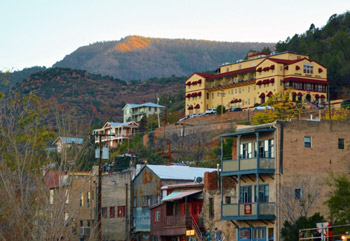
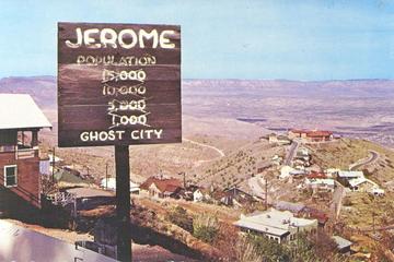
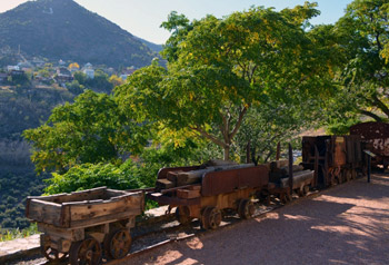 Jerome’s fascinating history began in the 1880s with the arrival of people from many parts of the globe to work the lucrative copper mines that brought its investors billions in profit. In its copper mining heyday, the population of Jerome swelled to over 15,000 and by the 1920s it hailed as the fourth largest territory in the state. Diversions for the miners’ long work hours were many and in the boisterous spirit of the West, lawlessness reigned. A New York newspaper dubbed Jerome “the wickedest city in the West.” The town boasted numerous saloons, Chinese restaurants and laundries and during Jerome’s more decadent times, brothels and bordellos.
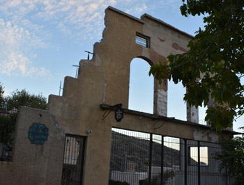 Just as Jerome precariously clings to Cleopatra Hill, the town desperately clung to life. It has survived, despite a long history of tragedy. Fire destroyed large sections of the town on three separate occasions, but Jerome always rebuilt. Devastating landslides and land shifts caused by hundreds of miles of unstable, honeycombed mine shafts under the city itself wrought more damage. An underground blast in 1938 rocked the town’s center, toppling the business district down the mountainside, including the city jail, which slipped 225 feet. Ghostly remains of these structures can still be seen today, some, a hundred yards or more from their original foundations. Untold human tragedies in the form of mining accidents, gunfights, opium overdoses and the flu epidemic killed hundreds. Yet Jerome stubbornly continues to survive.
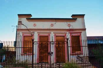 Over time, the population dwindled to a mere fifty residents and became a virtual ghost town. It was the Jerome Historical Society in the 1960s who saved the town from extinction through its preservation efforts and its proclamation that Jerome was America’s newest and largest ghost city.
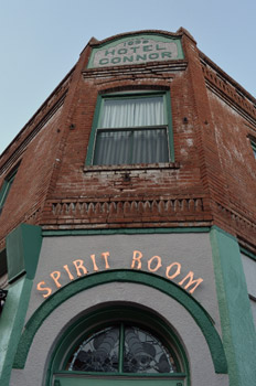 In the 1970s small groups of free- spirited artists arrived, restoring abandoned buildings and transforming parts of this ghost town into an arts community. Today, the thriving town with a population of almost 500 is home to quaint bed and breakfasts, restaurants, saloons, art galleries and unique, whimsical boutiques with colorful names evocative of the town’s history, such as Nellie Bly, Ghost City Inn and The Asylum Restaurant. Most of these businesses are located in buildings that date back to the 1800’s, forging an unforgettable link to the town’s storied past. No trip to Jerome is complete without a visit to the Douglas Mansion, home of the Jerome Historic State Park. The interesting exhibits in this stately home bring to life Jerome’s mining heritage and offer a unique glimpse of its glory years.
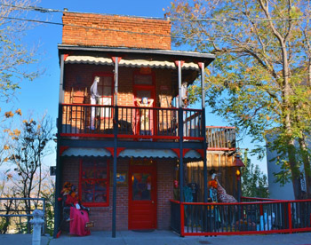 At almost a 5,400 feet elevation, Jerome Winery provides astounding views of the Verde Valley that go on forever. Visitors of today wonder if the town’s residents of the past were as awed by its striking vistas. But it is ultimately the sloped buildings perched precariously on the hillsides, dramatic switchback cobblestone streets, and abandoned ruins that the story of Jerome is told. It doesn’t take much to imagine miners walking the streets, hear the tinkling of a piano or the loud, raucous laughter emerging from the saloon and the occasional sounds of gunshots.
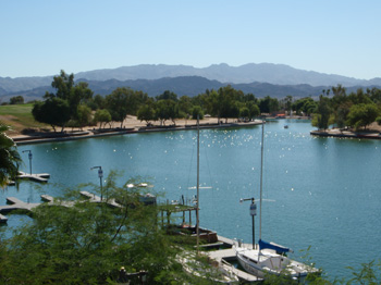 But closer examination of the burgeoning urban legend reveals that McCulloch was actually a shrewd businessman with a vision and a plan. The Arizona desert land he bought was a bargain. While not situated near any major highways, it was a popular fishing destination on the banks of Lake Havasu, a 45 mile long reservoir formed when the Parker Dam was built on the Colorado River in the 1930s.
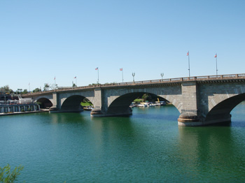 Two years after Mr. McCulloch’s purchase of London Bridge, I emigrated to Vancouver, Canada and forgot about London Bridge. Then in 1992 My husband and I decided to take a road trip, and were returning home from Disneyland via Las Vegas. I saw Lake Havasu City on the map and decided I simply had to see the bridge in its new home.
 The London Bridge Interpretive Center, however, was more down to earth. It provided fascinating information about the three-year project to relocate the bridge. When the bridge was dismantled, each piece of granite was carefully numbered to indicate its position in the structure. The pieces were then shipped from London to California via the Panama Canal, from where they were trucked to Lake Havasu.
 My sense that Lake Havasu was an extension of Disneyland was actually not far from the truth. To develop Lake Havasu McCulloch partnered with C.V. Wood, the president of the McCulloch Oil Corporation. Wood had previously assisted Walt Disney to develop Disneyland, and was subsequently involved in creating the first Six Flags Adventure Park. It was Mr. Wood who supervised the entire bridge moving project, and who undoubtedly gave the new planned community of Lake Havasu City its theme park flavour.
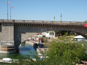 I returned to Lake Havasu in 2014. The population of Lake Havasu has grown dramatically since 1992. There are housing developments all along the lake, and the island is covered with condominiums and resorts.
 Chaco Canyon National Historical Park sits in Northwestern New Mexico and was designated as a World Heritage Site in 1987. According to archeological studies, 4,000 to 6,000 Hopi, Pueblo, Navajo and other Indian tribes passed through this canyon. From 850 A.D. to 1150 A.D., the Anasazi lived within great houses often oriented to solar, lunar and cardinal directions. There seems to be an unending fascination about the Anasazi’s and their use of sophisticated astronomical markers, water control devices and Chacon “roads.” At the Chaco Canyon visitor center a video program is shown hourly about these ancient inhabitants as well as a small museum displaying artifacts, maps and a small outdoor observatory.
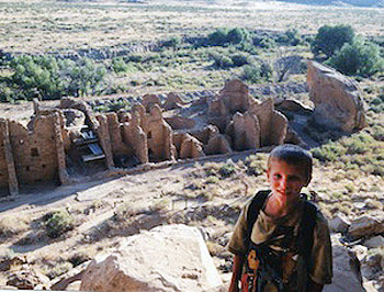 Self-guided tours are also available to the grand Pueblo Bonito, (Spanish for Beautiful Town) the largest Anasazi ruin, Casa Rinconado (Great Kiva) and Una Vida (another great house). For longer treks, there are at least a dozen trails leading to the top of the mesa for views of the entire Chaco Canyon network of ruins. Most are fairly easy with little elevation gain, the longest trail is a little over six miles. We chose the Pueblo Bonito Rim Overlook trail. After a steep one and a half mile climb the ruins of Pueblo Alto greeted us as a setting sun shadow danced across the canyon walls.
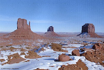
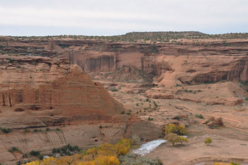
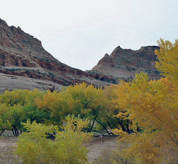
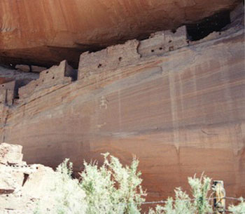 Canyon De Chelly National Monument resides in Northeast Arizona and is west of Chaco Canyon. Numerous overlooks of the canyon are accessible by driving a two-lane road that meanders along the rim. My favorite overlook was Spider Rock. Today, only two tall spires of red sandstone stand alone in the middle of the valley floor depicting Spider Woman’s home where she helped her People move into the fourth world by hiding them in the reeds and then floating them down to dry land.
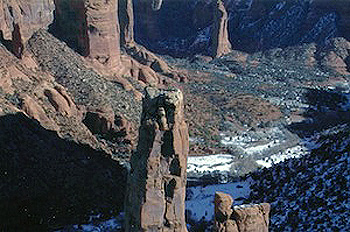 The Second World according to Waters was called “Dark Midnight” and was destroyed by cold and ice. Again, the kivas kept them warm and dry. Once the destruction stopped, they climbed up a ladder into another world. This was the Third World. Dissension broke out quickly among the People and this world was destroyed by flooding. However, this time an appointed caretaker named Spider Woman saved the ancients by hiding them in reeds and floating them to dry land into the Fourth World. The Fourth World, according to Waters, was called “World Complete.” This world was unlike the previous three, where the ancestors were provided for. The Fourth World had harsh deserts, never ending marshes and mountains of violent weather. This World was to be a time of awakening, realizing how we affect each other and that we are all one. Sounds like what might be happening now, doesn’t it? The Hopi say we are now living in the Fourth world which is ending and that the Fifth World is beginning.
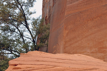
 Further south of Canyon De Chelly lies Casa Malpais Archaeological Park. This National Historic Landmark also has evidence of underworld activity within the ruins. Intact pottery was discovered here as well as a 8 X 4 foot panel depicting human like figures with tails which may have represented ancestral beings before they emerged above ground to the fourth world. These petroglyphs offer an inkling about the Zuni and Hopi clans that lived and held ceremonies here six hundred years ago. Archeologists propose these drawings came from the Parrot Clans because there is a parrot spitting rainwater onto a corn plant. According to Hopi legends, this indicates that the Corn Clan and Parrot Clan went their separate ways.


 I smiled at the typical mono-syllabic answer, but Amanda and I kept up our lines of questions. When pressed, he finally told us of the time he had been sent out in the middle of the night to find a group of Park Ranchers who’d gotten lost here in Canyon de Chelly (pronounced de Shay). He’d talked them down one cliff and walked them up another. He knows this place by heart, even in the dark.
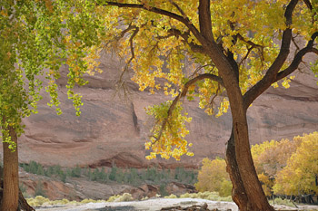 This is a rule that I can get behind, especially after Calvin pulled our 4×4 from the mud and told us about pulling hikers from of flash flood waters. But the guided-only rule isn’t just for safety. It’s a respect thing. The Navajo’s don’t want anyone else messing with their land. They’ve had enough of that. Bitter stories of conquistadors or explorers had made their way through my tours of the Zuni and Acoma pueblos, but Calvin’s story of The Long Walk hit me the hardest.
 Kit Carson knew how to solve this canyon problem though. Fire. In 1863 his “Scorched Earth Campaign,” burned all Navajo property in and around the canyon was burned. Traditional hogan homes, peach trees, and grazing animals were all destroyed. With no crops, little food, and only the charred remains of their homes, Navajo’s fled up the walls of Canyon de Chelly. But without canyon protection, they were easy targets for Carleton and Carson’s men and the many Ute Indians who were working with the colonels. Navajos spotted were giving a choice to make at gunpoint: surrender or be shot on site. Although a few people escaped, the majority of the tribe surrendered. Kit Carson’s plan worked.
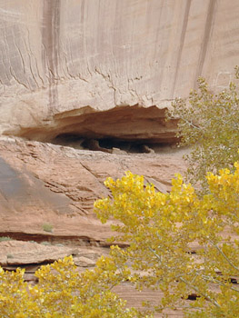 But Calvin knows all his grandma’s stories – even the sad ones. According to Navajo tradition, the grandmother chooses one grandchild (out of dozens, in Calvin’s case) to keep in the ancestral home and instruct in traditional Navajo ways. So as Calvin’s parents and siblings eventually left the enclosed walls of Canyon de Chelly for jobs in Gallup and Phoenix, Calvin stayed behind. He played in the prehistoric cliff dwellings high in the canyon walls and he tended to goats on the valley floor. He hunted skinwalkers and slept in hogans and learned from his grandmother. When he was twelve, the US government discovered that there was an un-schooled child living down in the canyon and officials came to take him to school at Fort Wingate. Upon overhearing that his long hair would be chopped off the next day, Calvin embarked on a mini-long walk of his own, finding his way back to his grandmother and those orange canyon walls. She had breakfast waiting for him.

