by Alison O’Neil
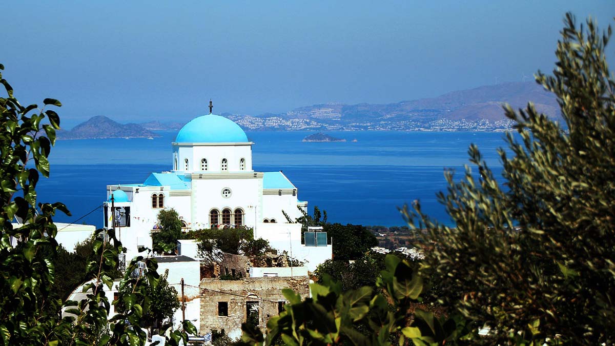
Visitors to the Greek island of Kos might be unaware when they arrive of the historical importance of this island but in between enjoying the glorious sunshine, warm waters and beautiful views you cannot go far without stumbling across ancient ruins and landmarks.
My interest in the history of medicine, a fascinating topic I have been teaching for the last ten years, was what drew me to the island. The Greeks contributed much to the development of modern medicine. As great thinkers they suggested that illness came about as a result of liquids in the body becoming unbalanced, if you were sick this was due to too much or too little blood, phlegm, black bile or yellow bile. This idea continued to influence medicine for the next 1000 years.
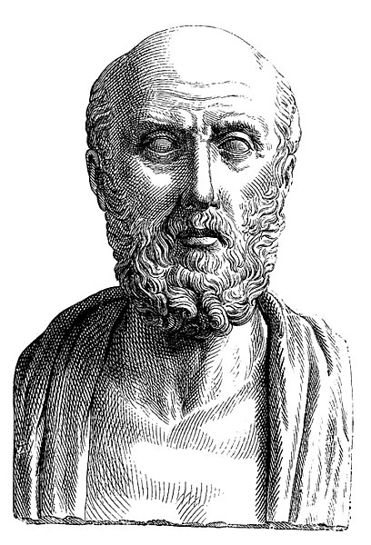 One of the most important figures in ancient medicine and possibly the most famous past resident of Kos is Hippocrates. He lived around 460 BC and is known as the father of modern medicine. Before Hippocrates, many diseases were explained away through stories, curses and evil spirits. He put medicine on a course of rational explanation and steered it away from supernatural theories. The Hippocratic Oath that all modern doctors take is named after Hippocrates as the ideals of confidentiality and using medical knowledge only for the good of patients were ideals in which Hippocrates believed.
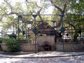 Hippocrates Tree is located in Kos Town. It is said Hippocrates stood under this plane-tree and lectured his medical students. Although it is unlikely that it is the actual tree under which Hippocrates stood, a far more plausible explanation is that the current tree is a descendant of the one under which Hippocrates lectured. Many health establishments around the world have taken cuttings from this tree and planted them in their own grounds. Hippocrates tree is easy to distinguish as it is supported by a large metal framework. I could not help but feel impressed that a man to whom medicine owes so much might have once stood in this same spot.
A site definitely linked to Hippocrates is the Asklepion located a short drive inland from Kos Town or alternatively you can take the little tourist “dotto train.” The Asklepion is a temple built to honour Asklepios, the Greek god of healing. Although the Asklepion adopted much of Hippocrates teaching it did in fact hark back to the days when gods were blamed for illness and demonstrates the conflict between natural and supernatural ideas about illness that existed when it was built in the third century.

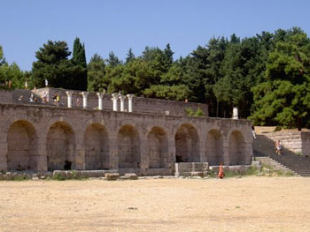 The sick would visit the Asklepion which was staffed by several therapists, priests and later doctors. The patient stayed for a few days and might take part in massage, gymnastics, bathing and follow a special diet.
As far as most people were concerned the real treatments came when you visited the Abaton, where you would leave a sacrifice to Asklepios and then quite simply fall asleep! It was believed Asklepios and his helpers would then visit and heal you. Many patients spoke of seeing Asklepios in their sleep when he visited them holding a staff and accompanied by sacred snakes. They woke up healed. It is possible that the power of placebo played a role here or that the patients were given an intoxicating drink and then visited by the temple staff. The staff and snakes are still a symbol associated with medicine today.
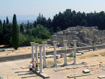 As you approach the Asklepion it opens out in front of you and you can clearly see the three levels that make it up. Naturally, the main temple to Asklepios is at the top. I made my way slowly to the top, partly due to the heat but also so as not to miss anything on the way. My guidebook informed me that the lower levels were once accommodation and that the second terrace contained smaller temples, including one to Apollo. The authentic columns, arches and stone steps still look impressive and make you wonder about the people who used the Asklepios as a centre of healing all those years ago.
The view from the top makes you appreciate the green and beautiful island of Kos. I wondered if perhaps it was the location of the Asklepion that healed the sick, in the peace and quiet, away from the busy town and in the beautiful countryside I would defy anyone not to feel at least a little better then they had before their visit.
Private Tour: Kos Island Highlights Including Zia, Asklepieion and Tree of Hippocrates
If You Go:
Direct Flights from most European cities go to Kos International Airport. This is located in the centre of the island close to the village of Antimachia, about 22 km from Kos Town.
Most tours can be booked from the marina in Kos Town or in your hotel. The Asklepion can be reached using the tourist train from Kos Town.
Accomodations: I can recommend the Continental Palace Hotel in Kos Town.
About the author:
Alison writes about many things but her two main passions are history and travel. Her travels have taken her mainly through Europe and Africa but she intends to cover as much of the globe as possible! She is also a teacher and hopes that through her writing and teaching to share her love of the past.
Photo credits:
First Kos, Greece photo by: Greg Montani from Pixabay
Hippocrates bust: Public domain
All other photos are by Alison O’Neil.
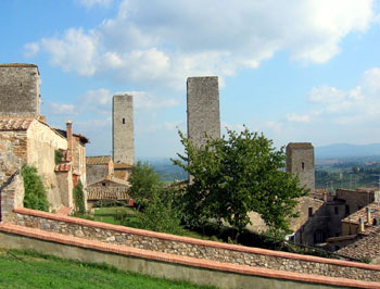
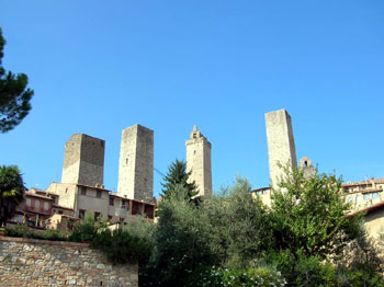
 The first written records of this Estrucan village are from 929 AD. Named for the former Bishop of Modena in the 10th century San Gimignano is a Unesco World Heritage site and is also known as the city of beautiful towers. During The Middle Ages while at the peak of it’s influence this town boasted fifty-six towers, some standing more then fifty meters tall and visible from anywhere in the Elsa Valley. These towers were not only status symbols to local families as well they served as a medieval early warning system should would be invaders approach. Because of war, the Black Plague in the 14th century, urban renewal and other catastrophes only fourteen of the towers remain and only one, The Grossa tower was open for our viewing.
 Being surrounded by so much history can be a little over whelming so we took a time out to clear our heads and check out the terra cotta and glazed pottery. Crafts and pottery that have been produced by local artisans are abundant in the open-air market and shops along Via Giovanni. I couldn’t resist bringing a handcrafted ornament home for my grand daughter.
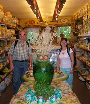 Fattorio Lischeto boasts a restored rustic farmhouse where we enjoyed the best of Tuscan cuisine and the company of fellow travelers from around the globe. The panoramic views of the surrounding farmland, Cypress groves, rolling hills and valleys could only surpassed the crispy crostini and pancheta, organic pecorino cheese, panchino tomatoes freshly picked from the garden and a drizzle of virgin olive oil. I still smile when I think of the organic Chianti.
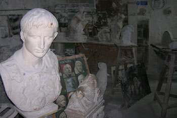 While San Gimignano is a busy tourist destination Volterra is what I had envisioned when I thought about an ancient Estrucan town. The City of Alabaster as it is known became important in the 18th century in part because of the quality and transparency of the alabaster in the region. To this day craftsman work in the dust filled workshops where you can watch them work and spend whatever amount you desire large or small for your memories. In celebration of their history of carving Volterra’s Museum of Alabaster boasts over three hundred original pieces, displayed in a 17th century convent.
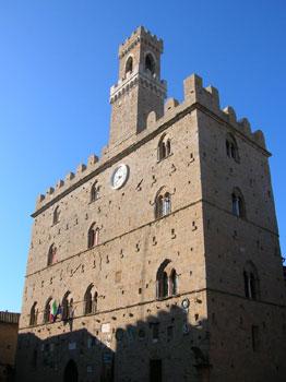 Early Roman influence is apparent in Volterra with the recent (in Tuscan time) discovery of the ruins of the Theatre of Vallebona from the 1st century and spa buildings from the Augustun age (5th century). Many of the archaeological finds from digs in and around Volterra and the Elsa Valley are displayed in the Guarnacci Museum, one of the first public museums in Europe that was founded in 1761 while the Romanesque style church of St. Agostino is the home to remnants of famous frescoes.
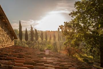
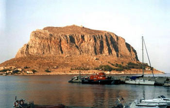
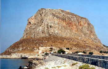 Hidden on the slopes of a great rock known as the Gibraltar of Greece, Monemvasia is one of those rare treasures that tourists usually by-pass. It’s a magical experience visiting this little medieval site. The entire town is walled and invisible from the shore. The steep rock, crowned with its Venetian fortress, is connected to the mainland by a narrow causeway. Motor vehicles are prohibited, but a mini bus takes you free of charge to the old city gates.
 From Monemvasia I took the early morning bus heading for Koroni, another Venetian town. After a circuitous route through Sparta, I arrived at Koroni that evening. The castle of Koroni was lit by a mystic green light. Above its turrets, Mars blinked its red beacon; a crescent moon illuminated the sky over the twinkling lights of the village; little kaikis bobbed on the moonlit sea.
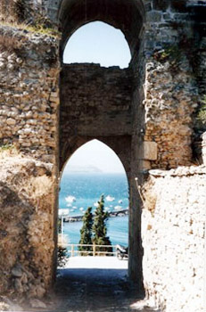 The old town of Koroni has long since fallen into ruin, but the Venetian architecture has been preserved, with wrought iron balcony railings, arched windows and doors. The largest, two-storied mansions and public buildings are on the waterfront, while higher up are the smaller Laika (folk) houses with small inner courtyards. One distinctive feature of the Koroni houses are the curved tile roofs and unusual terracotta eave decorations: instead of the usual palmettes, these are like small winged angels.
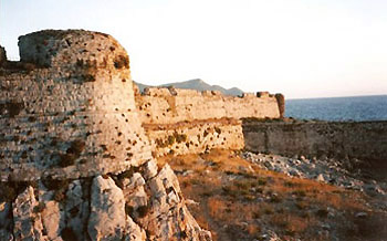 Which set of the many instructions, bus schedules, and info that I was given by Greek locals would prove to be the right one? After various suggestions I decided to go with the English speaking baker who even drew me a map to explain which village to get off to catch the bus to Pylos/Methoni which, he said, went past every hour. According to his directions, I disembarked at the cross-roads at a village called Rozymalos and waited at a kafeneion for just over an hour until the bus finally arrived.
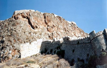 Methoni’s 15th century Venetian fortress expands over the whole area of the south west cape. Built over ancient walls, it was the prize of many invaders over the ages. The walls loom imposingly over a setting filled with memories of the past. The castle has a protective moat on the land side and is surrounded on three sides by the sea making it impenetrable.
 Rising seventy metres on a black shale bench above the glacial silt plains of the River Boyne sit three megalithic tombs of the Neolithic or Late Stone Age also known as Passage Tombs or burial tombs. They date around 4000-2500 BC – Newgrange, Knowth and Dowth being the major ones – and are situated midway down the east side of Ireland.
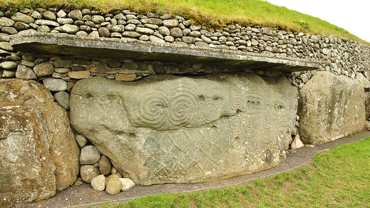
 Passage Tombs have several common features: a mound in the shape of an egg called a tumulus. It is 85 meters across, 13 meters high and covers one acre. It is defined by a ring or kerb of 97 stones, a passage way and a chamber. I knew without doubt that this is where we got our word, curb which has the same basic use today – to define a certain boundary The building of the three Passage Tombs above the River Boyne seems to have developed over several hundreds of years, the design finally climaxing in the shaping of a cross. With a central space at the end of the passage way it also has a chamber on each side and also beyond it, making a very crude cross shape.
 Waiting for my group of ten to enter the passage way, I wandered around the outer path surrounding this UNESCO World Heritage Site. Returning to the opening I suddenly found myself alone. The site’s guide and the group had disappeared into the Tomb. I had to find a place to leave the umbrella and luggage and strapping my knapsack onto my chest I ducked low under the stone lintel of the entrance. All was darkness. I had to move sideways for most of the passage was very narrow. I could hear voices ahead. I was well aware that I was walking where my Irish ancestors had walked, where they had brought their dead to cremate. I finally came out to a dimly lit rounded chamber where a large three-spiral stone sat in a recessed part of the earth floor. Small chambers opened off the larger chamber to roughly take the shape of the cross. Three large stone basins, each about one metre wide were thought to have been used in cremation ritual. The tomb was plundered in the late 800’s AD by Viking raiders and after its recent excavation there is nothing left but the stone structure.
 During the early days of Newgrange’s excavation there was a growing belief that the rising sun, at some unknown time, used to light up the three-spiral stone at the end of the passage. Finally on December 21st, 1969, the excavating crew investigated this idea. They recorded that the sun appeared above the horizon and a small shaft of light about the width of a pencil entered the roof-box. It was an aperture like as in a camera, l meter by 0.25 meter, and had been built behind the first lintel and below the second. This very narrow shaft of light shone along the whole passage to reach to one of the basin stones in the end chamber. Quite quickly the light widened to a 17 cm shaft and swung with a life of its own across the end chamber and the tomb was entirely lit. Shortly this 17 cm band of light narrowed and finally ceased to shine at all into the tomb. The tomb was again in darkness. For seventeen minutes, it was recorded, direct light entered Newgrange, not through the main door but through the specially designed slit which laid under the roof-box at the outer rim of the passage. It was most obvious that a specialized ritual of bringing the light into the tomb during the winter months was established. Since the burial tombs were a place of reverencing the dead, it is thought that the purposeful entering of the light was possibly symbolically giving the dead a passageway to the afterlife. Six thousand years ago, our ancestors had developed a ritual honoring the winter solstice—the sun’s rising on the shortest day of the year. I was in awe at the knowledge these ancient ones had possessed and had passed to us. I stood where ancient ritual had taken place and felt part of the eternal link that connected us all and I felt gratitude.
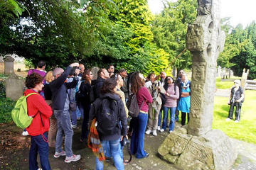
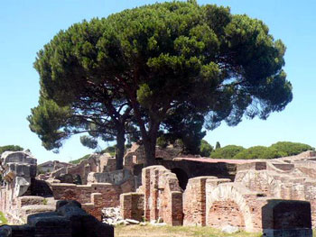
 The Italian government has done a great job instructing visitors with strategically placed information about the site. We also liked the fact that they give you the freedom to discover Ostia on your own. Signs warn visitors to have respect for the artifacts. Because of atmospheric exposure and those created by the nearby airport, some of the monuments are wearing down. We wandered off the Decumanus, and. onto narrow paths scattered with pine needles, ducking under archways, and poking around alleys.
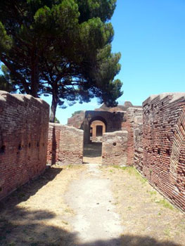 Just beyond the warehouses we climbed the few steps on our right. Here were the Baths of Neptune, a gathering place for the locals. An amazingly preserved mosaic, measuring 55 feet by 36 feet, is of the sea god riding a chariot drawn by four pawing horses.
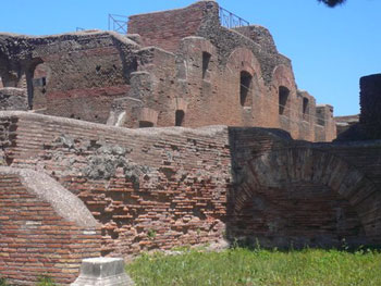 We pictured the locals sitting in baths, then walking down the Maximus to imbibe a few cups of wine at the Insula of the Thermopolium.
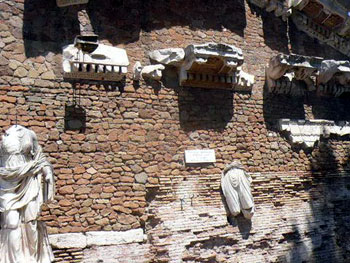
 After navigating almost the length of the Maximus, we came to the Forum, the main square of the town. Here were the remains of important government and religious buildings. Many of the pillars and building foundations have been left standing. The huge Capitolium Temple dominates the right-hand side. Most Roman forums were dominated by a temple – to bring the deity to the people. The Capitolium Temple was dedicated to the pagan trinity of Juno, Jupiter and Minerva. Columns flank the massive staircase leading to the entrance. At least two stories are visible. Before heading back, we stopped at the near-by museum to view the busts and statues of the local citizenry. Most amazing is the detail to features, hair styles, and dress. My favorite was a soldier in a pleated kilt, headpiece, shoes, and weapon. There is also a room with more of the marble sarcophagi showing carvings of Dionysus, the Greek God of wine.
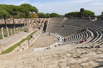


.jpg)