Travel Thru History

Historical and cultural travel experiences

  • Home
  • Airfare Deals
  • Get Travel Insurance
  • Writers Guidelines

Mexico: Exploring Toltec History in Tula

Tula Mexico

by Zach Lindsey 

I must’ve taken a wrong turn after the ruined church, because I’d been walking for nearly 20 minutes, the mean sun of central Mexico burning my neck.

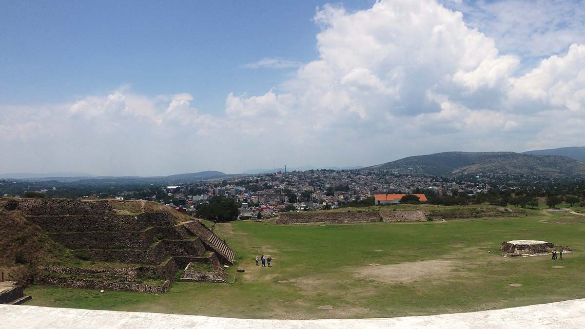
I turned onto a trail I hoped would lead me back to the Atlanteans, and I saw thousands of red slivers in the dirt in front of me. They were ceramic potsherds, most no bigger than my thumb, all nearly a thousand years old. This was the evidence of the scope of the Toltecs, their city so large fields of its debris were scattered for kilometers around the stone ruins.

Their ceramics are so common out in these woods that these tiny shards don’t even interest professional archaeologists. But I was interested. I picked one up and held it. Before I put it back down, I thought of the person whose thumb must have slipped along the lip when it was made.

Tula (sometimes called Tollan) outside the present-day city of Tula de Allende a couple hours away from Mexico City, was once home to the Toltec people.

When Toltec potters worked en masse here, a great power had recently fallen, the city of Teotihuacan. Toltec leaders used the power vacuum in the region to become the new leaders.

Compared to the people of Teotihuacan, the Toltecs were a flash in the pan. Teotihuacan was at its height from 200 CE to 750, whereas Tula began to grow in 900 CE and by 1150 collapsed from environmental and political pressure. But the Toltecs influenced cultures as far apart as the Maya at Chichén Itzá and the Aztecs, and their idols and monuments brought confusion and wonder to early archaeologists.

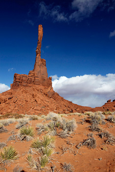
That confusion is clear in the lasting name given to the sculptures on top of Pyramid B: Atlanteans.

Toltec sculptures
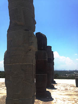
There is something almost otherworldly about the sculptures. Ethnocentric archaeologists who found similar sculptures at Chichén Itzá couldn’t believe the locals had made them. Easier to believe they came from a lost civilization of Europeans, the fabled philosopher-kings of Atlantis. While we now know they weren’t made by some mystic drowned merfolk, the name stuck.

Their butterfly pectorals are an example of how cultural metaphors do not always transition. We may think of butterflies as gentle and peaceful, but to the Toltecs, they were a symbol of war.

The Toltecs loved war. They may have brought heart sacrifice to the Maya region; if that’s true, the Maya had human sacrifice before the Toltecs, but they didn’t remove the heart. They certainly introduced the Maya to Chac Mool, a conduit between humanity and the gods.

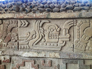
Toltecs likely placed human hearts removed from warriors captured in battle on the plate Chac Mool held on his belly. Then they burned them. They also introduced other symbolism, like the great serpent god Quetzalcoatl. The feathered serpent may have been an allusion to a legendary or real Toltec king.

They also introduced the tzompantli, the terror-inspiring wall of skulls that, like heads on a pike outside a medieval castle, was probably meant to put the fear of the state in enemies.

It must have worked, because the Toltecs had been elevated to the realm of legend by the time the Mexica (one part of the Aztec Alliance) arrived on the scene. Mexica nobility even claimed descent from the Toltecs as a way of proving how dangerous they were.

Toltec carvings
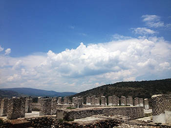
Compared to their predecessors the Teotihuacans, the Toltecs were no masters of pottery, despite the litter they left behind. Yet their masterful stonework inspired builders for a thousand miles around them. The old, deconsecrated temples they made still stand like sentinels staring down at contemporary Tula de Allende as though they’re still ready to send out the soldiers if necessary.

While stones have chipped away and columns have collapsed over centuries, the ghosts are still there and faithfully cared for by the folks at Mexico’s National Institute of Anthropology and History (INAH). Even on the day I visited, INAH workers were out hauling dirt and reassembling collapsed stone.

Tula may be most important for the place it occupied in history, not what it was or who its people were. Some archaeologists even believe the Toltecs didn’t exist, that someone else lived here. Whoever they were, they rose after the fall of Teotihuacan. They inspired the Aztecs and helped alter the Maya government at Chichén Itzá.

Toltec temple ruinsIt was its own land, a unique culture with a unique outlook on the world and unique problems. This city was once home to as many as 40,000 people, whose lives have been reduced to the litter they left and the influence they had.

Today, their banners, streamers, and rich feather decorations rotted away, organic paints long gone, it’s hard to imagine those lives. But, like all the great archaeological sites, it is possible to blink at the top of Pyramid B and remember that you’re looking out at the same mountain they looked at, with the same type of scrub brush and cacti clinging to the side of it. Or maybe, you’ll turn a corner at Tula like I did and be able to put your thumb where a Toltec once put theirs.

As for the colonial-era church which also sits on the site, well, after years of traveling Mexico I’ve learned that the Spanish imprint can be as beautiful as the indigenous imprint. But there is something nice about seeing just how ruined the church is in comparison with nearby stone structures that have survived longer and better. Just don’t take a left at that church.

If You Go:

  • Tula is a great day trip out of Mexico City. Buses go there regularly, and a taxi driver can take you to the ruins, which, despite being quite isolated on a plateau, are surprisingly accessible from the city core.
  • Bring water and lots of sunscreen. If you’ve just spent the last few days in Mexico City, you may be used to room-temperature weather, but Tula is at a lower elevation, flatter, and just plain hotter.
  • Buy something from the souvenir vendors! They have some of the best vendors I’ve seen, selling things better by far than the weird medley of Maya imagery and American football symbols that show up at Chichén Itzá or the fairly bland objects most vendors at Teotihuacan sell.
  • The museum is nice, but if you’re in a hurry, skip it in favor of the ruins. As I said, the Toltecs weren’t the greatest potters in Mesoamerica by any measure.
  • It’s illegal to take anything from an archaeological site, even if there are thousands of potsherds here!

About the author:
Zach Lindsey is an Irish-American English as a Second Language instructor and student of historical linguistics. He is interested in the way architecture, stonework, and murals communicate cultural values. You can see more photos of art and architecture he’s seen on his journeys on archaeogato.tumblr.com.

Photos by Zach Lindsey:
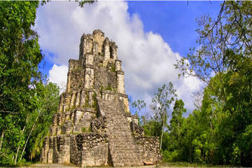
A view of Tula from the top of Pyramid B
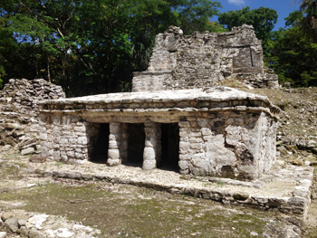
The Atlanteans on top of Pyramid B
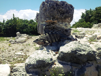
A snake with a skull emerging from its mouth
Columns at Tula

Tagged With: Mexico City attractions, mexico travel Filed Under: North America Travel

Manitoba: My Fondest Christmas Memory

christmas horse and sleigh
by Irene Lynxleg 

Because of the great distances between communities in rural western Manitoba, our priest couldn’t attend each village for Midnight Mass. I remember when I was 10 years old it was his turn to come to our village.

That evening we got ready and dressed warm with our home made clothes, woolen coats, hats and mittens and brought wool blankets to cover and keep us warm for the sleigh ride to church.

The church with the little white steeple was the tallest building in the community. The steeple pointing to the sky looked like a lonely unicorn sitting on the snow waiting for company.

It was four miles from our farm; too far to walk. My dad and brothers hitched our two plough farm horses to the sleigh and attached bells to the harness. The sleigh had an open box with seats all around except on the front, where a large plank provided a seat for the driver.

Hay was scattered all over the floor of the box to keep our feet warm. It also served as the horse’s food during the service. The horses were brothers called Pat and Jim. They had beautiful black shiny coats and tails with white blazes and looked as though they were wearing tuxedos for a special occasion.

As they trotted pulling the sleigh their breath sent out streams of air like the old locomotives trains. Their tails swung and danced to the rhythm of the swinging bells which could be heard for miles, especially on a cold crisp winter night.

My oldest brother was the driver that night and Mom sat beside him. My Dad did not attend the service. His church was the woods where he would go alone to talk to his Creator.

On the trip we talked, laughed, sang and teased each other to make up for having to be silent during the service. When we arrived we tied up the horses and fed them and brought in our blankets to line the cold church pews. The wooden stove was too small and did not heat the whole church.

When we entered most of the people were already seated. Each family occupied one whole row of the church benches. The parents allowed their children to bring their home-made toys: sling shots, drums, flutes, little dolls dressed in leather and feathers. For snacks we brought dried strips of meat moose, deer, rabbit and bannock packed in empty metal Shamrock lard pails.

The Midnight Mass in my native community was a special Christmas event. The parents socialized after the service and the little children fed Baby Jesus their snacks. During confession time, the grandmas and mothers sang native hymns in the upstairs balcony.

They were called the Crepe Paper Singers because they could not afford to buy lipstick. The women used the red crepe paper that was used for Christmas decorations that was kept hidden behind the old organ in the church. They wet the red paper with their saliva, then applied it to their lips to transfer the deep red dye. I still remember one of the hymns the Crepe Paper Singers sang called ‘Jesus Has Arrived’ (in Saulteaux it’s ‘Aja A Binogee Jesus’). I used to sing it at Christmas for my grandchildren.

After the service we wished everyone a Merry Christmas, climbed into the sleigh for the ride home. As we rode along in silence I noticed it was very light out. I looked up at the sky and saw the evening star Venus, also called the Star of Bethlehem or the Christmas Star.

Opposite the Christmas Star a beautiful golden full Moon glowed. The moonlight lit up the snow-covered ground, and the crusted snow flakes were wearing sparkling diamond tiaras.

When we reached home, before we entered the house we smelt the aroma of cooking. Our father surprised us with a special midnight late dinner. On the table, instead of a turkey was a roasted beaver and from our root cellar he cooked onions, potatoes, carrots and turnips. We thanked the Creator for our wonderful evening and meal and quietly went to bed.

Now every Christmas when I see cards, churches with steeples, horses pulling sleighs and jewelers advertising diamonds, the sparkling snow wearing diamond tiaras, I think of my sleigh ride in the moonlight and my roasted beaver dinner.

If You Go:

Things to do in Winnipeg, Manitoba during Christmas holidays

About the author:
Irene Lynxleg was born on an Indian Reservation 77 years ago in Southern Manitoba (Tootenowazubeng). She was the only child on the reservation to complete Grade 8 but was subsequently sent to a Catholic Residential School. She lived most of her life off the reservation. She has been writing seriously with guidance from the Brock House Society for about 3 years. In 2015, Irene received the Cedric Literary award for First Nation’s writing.


Photo of horse and sleigh byPete Markham from Loretto, USA / CC BY-SA

Tagged With: Manitoba travel Filed Under: North America Travel

Mexico: The Lost City At Cancún

El Ray temple

by Zach Lindsey

A postclassic Maya temple in Cancún looks to the south, across a road full of microbuses and hot red cars with inebriated passengers, across a golf course, across a line of trees, into a secluded cluster of ruins called El Rey.

El Rey and San Miguelito are archaeological sites that are less than two kilometers apart on the main drag of one of the most heavily-trafficked tourist communities in the world, yet there are cab drivers and city bus drivers that don’t know where they are.

pyramid at San Miguelito stairway
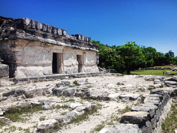
There are many good reasons to go to Cancún: a long, relaxing break from a stressful job, a way of visiting other cities in Quintana Roo and Yucatán like Tulúm or Mérida, a chance to renew your visa if you’re living abroad and you need an immigration office that is used to dealing with the weird errors American tourists are capable of making while filling out paperwork.

Learning about ancient Maya culture is not usually listed as one of them. Cancún is a city without history, a place where Mexican financers were allowed to build a completely Mexican city without colonial Spanish architectural influences. They picked a location with an incredible view of the Caribbean, sandy beaches, and forests of mangrove trees. Virgin territory.

But not quite virgin.

It’s no surprise the Maya built stone structures on the island that is now Cancún’s hotel district; on the less-developed portions of the island, there is still a beauty in the sharp contrast between green vegetation and tan sand. As Maya Research Program archaeologist Mark Wolf once said, “The ancient Maya were just like us. They liked a room with a view.”

When planners designed the main street that runs through the hotel district in Cancún, Boulevard Kukulkan, they were faced with the ruins of these structures and evidence of long-gone wooden houses between them. To the west of that was the lagoon separating the island of Cancún from the mainland. To the east was the temperamental Caribbean with its potential for flooding and violent hurricanes.

They decided to go down the middle.

The ruins on one side of the road are named San Miguelito; the ruins on the other side are El Rey. It’s hard to know for sure if they represent closely linked but separate cities or complexes from the same city.

There is one big clue, though: the pyramid at San Miguelito.

Iguana at El Ray templeCuriously, this temple faces away from the other stone buildings at San Miguelito. Instead, it faces El Rey. Between the pyramid and El Rey, there may have been an uninterrupted stretch of houses and other structures. Unfortunately, “low level houses were not registered during the design and construction phase of the hotel zone during the seventies,” according to a National Institute of History and Anthropology (INAH) placard at San Miguelito.

Online, INAH mentions that San Miguelito extended for three kilometers and includes “the current archaeological site of El Rey.” This might be backwards, since El Rey seems to be the older of the two sites. Either way, this information isn’t at the sites.

The Maya first started developing at El Rey probably around 300 BCE. For many years, it was a stable but sleepy fishing town. It wasn’t until centuries later when coastal trade and an increased emphasis on the Yucatán peninsula allowed them to get rich. The extant structures at El Rey mostly date to the Late Postclassic era (from 1250 CE to the arrival of the Spaniards); all the structures at San Miguelito popped up around this time.

INAH claims the population did not increase during this boom, but it’s hard to know for sure without the houses destroyed and unrecorded by developers. Still, what is left today could be used in a textbook to discuss Postclassical Maya culture in the region. And whether they are one old city or two, the two archaeological sites of San Miguelito and (especially) El Rey are usually surprisingly peaceful and free of visitors.

Perhaps the most obvious characteristic of the two sites is the use of circular columns to support flat ceilings. Before the introduction of columns in the Postclassical Era and in Yucatán, the Maya used tapering false arches, and their rooms were inevitably tiny as a result.

Columns at El Ray temple

Square columns are well-known in the Yucatán region, like at Chichén Itzá, and may be of Toltec origin. But the Maya of this region used carefully-rounded stone to create circular columns, an aesthetic choice that is still evocative as their shattered remnants rest, sometimes crooked, on settling, cracked foundations.

Columns allowed the Maya to build a sprawling building at San Miguelito called Chaak Palace by archaeologists. Chaak is the god of rain; symbols likely representing him appear on the staircase leading up to the seven-room palace. The palace itself was likely used for ceremonies and banquets, with its large central room and two temples. Priests or nobility may have also lived on the premises, as the remainder of the palace rooms appears to be homes.

They may have walked the short path between the palace and the back of the pyramid, stopping first at a small, two-roomed structure with rich murals of fish and other sea creatures to prepare. This might have meant steaming in a sauna or even cutting themselves to draw blood for the gods. You can still see the foundations and the bottom of the fading mural of this small structure at San Miguelito today.

Then, they would have walked up the pyramid to stand in the temple on the top and address city residents. Likely, they would have viewed the bustle in the slightly older buildings at El Rey from up so high.

Today, the ruins of El Rey are at kilometer 18, across the street (and yes past the golf course; try to keep your snickering and cynical commentary to yourself for a moment).

Perhaps the most well-known structure there is a well-preserved two-door temple with the smooth rectangular walls and decorative band of carved stone beginning a foot or two over the doorways. It could be used in a textbook to describe the architectural style known as costa oriental (‘east coast,’ which is what coast Cancún is on). You will see again if you go on to visit Tulúm, Muyil, or a dozen other sites in Yucatán. In other places, temples like this one have images of the descending god, who is usually associated with honey.

temple at Muyil
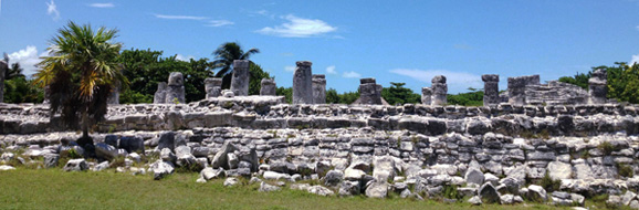
Most of these buildings as we see them date to the Postclassical era, but like most Maya structures, they were built in phases. The costa oriental temple had at least two construction phases. The pyramid at San Miguelito had at least three.

These building phases often seem like wrapped gifts to archaeologists: dig through one layer and find the next, even better-preserved, underneath it. Three phases is perhaps a lot for a relatively new, small pyramid like the one at San Miguelito, another sign of the financial success of the people who once lived here.

In truth, the ruins are hardly unknown on the Internet, but they are not frequently visited. This may be because travelers going on to other parts of Mexico imagine bigger temples and travelers staying in Cancún imagine nothing more than relaxation. They represent a lost city only in the sense that, in the haste to develop Cancún, parts of its identity were swept away. What was one became two.

Lots of people say Cancún doesn’t have a history, but the ruins prove it does. Before it was a tourist spot, before it was the site of haciendas, before there was a Mexico, this area was a vibrant trade hub for the cultures of Mesoamerica, probably even a seat of regional power.

If You Go:

♦ To see the ruins, start at the Cancún Maya Museum early in the day (the ruins close earlier than the rest of the museum, as I found out the hard way). Later, take a bus or taxi up to El Rey. Ask to get off at Kilometer 18. Not too far across the street is a nice public beach. Make sure to do the beach last, because an afternoon on a Cancún beach will make you far too lazy for this trip.

♦ If you see only one set of ruins on your trip to the Yucatán region, San Miguelito and El Rey probably shouldn’t be it. There are better preserved, better restored and better presented ruins on the Yucatán peninsula, like Coba, Uxmal, or Ek Balam. But if you plan to see a few, or you’ll be staying exclusively in Cancún, El Rey and San Miguelito are essential.


Private Tour to Muyil Ruins, Tulum and Coba from Cancun

About the author:
Zach Lindsey is an Irish-American English as a Second Language instructor and student of historical linguistics. He is interested in the way architecture, stonework, and murals communicate cultural values. You can see more photos of art and architecture he’s seen on his journeys on Arqueogato.tumblr.com.

All photos are by Zach Lindsey:
The costa oriental-style temple at El Rey.
The stairway of the pyramid at San Miguelito which faces towards El Rey.
One of the inheritors of the ocean-front view at El Rey, an iguana.
Columns at El Rey
Another costa oriental-style temple, this one at Muyil a few hours to the south.


Tagged With: Cancun attractions, mexico travel Filed Under: North America Travel

Arizona: A Journey Into Navajoland

west mitten

by Victor A. Walsh 

In the winter silence, colossal shafts and spires and mesas of rock rise out of the early morning light as if they are giants glazed in mantles of stone. Their presence is daunting, otherworldly—something I feel implicitly but do not understand.

“The Navajo call Monument Valley Tsé Bií Ndzisgaíí. It means “The Clearing among the Rocks,” says Harry Nez, our soft-spoken, middle-aged guide from Navajo Spirit Tours.

Directly in front of us, towering above the snow-splattered dunes of red earth and patches of scrub are two imposing buttes called The Mittens.

Big Hogan“It looks like a place where the dinosaurs once roamed frozen in a time capsule of volcanic rock,” I gasp.

“Actually, the rocks are much older than the volcanoes,” says Harry. “Geologists say that they were formed from an ancient sea, but for us they represent the lives of the five-fingered people who came from the underworld.”

“On the left,” he says, pointing to the closer butte silhouetted black against the horizon, “you can see a man’s head frozen in stone. The long narrow column is his hand. On the right in the distance is East Mitten, which is the woman’s head and hand.”

“The bodies inside the earth,” he further explains, “are where the First People, the holy beings, came from. The hands are a reminder to us that the ancient ones will someday return.”

Totem Pole
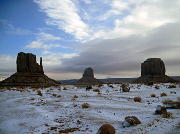
Harry continues driving along the route made famous in John Ford’s classic film Stagecoach (1939) through an eerie, snow-dusted landscape of gouged, red-brown hills and gullies cradled by massive buttes. It’s as if nothing has changed since that time. There are no paved roads, power lines, restaurants or public restrooms — just a few scattered Navajo hogans veiled in gray mist. But everything, including the Navajo’s traditional way of life, is changing.

The 27,000 square-mile reservation, the largest in the nation, is now in the throes of unprecedented crises: a two-decade long drought; an increasingly hotter and dryer climate, and waterways and wells polluted with radioactive waste from abandoned uranium mine tailings.

Rivers are flowing less often. Cottonwood and willow trees are vanishing. Shallow aquifers no longer have year-round water. Sacred springs and ceremonial and medicinal plants are disappearing along with eagles, cranes and bees. Raising sheep and other livestock, integral to traditional Navajo culture, has been declining for decades because of less forage and water. Since the late 1970s there has not been enough water from streams to grow crops.

Spearhead and Rain God mesas
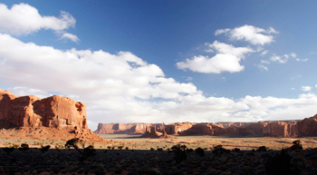
Navajo elders remember snows from the 1940s that were chest high on horses. They mention grass so thick and tall that sheep could get lost in it and soil that stayed damp through spring. It was a world they understood and identified with, but weather patterns now are extreme and unpredictable with no seasonal order. “The wind today is different,” says Janis Perry. “It is upset with us. You can see it in our sheep. They are constantly fatigued.”

There is less snow pact now, warmer spring months, and more wildfires, insects and dust storms. The latter bury everything, transforming once viable rangeland into desert expanses, especially in the arid southwestern part of the Nation. What is unprecedented and alarming is that the sand dunes and sheets, a typographical feature for thousands of years, are now moving because of sparse vegetation and stronger winds. As they grow and move, local ecosystems are destabilized and disappear, and opportunistic plants such as the rootless Russian thistle or tumbleweed move in.

Ear of the WindAll of this eludes me in winter’s cocoon at an elevation of 5,200’. In the afternoon light, the red-rock spires and mesas, sculpted in such a cacophony of shapes, rise above the dust-laden emptiness. They stand alone, as if haunted. North of Totem Pole, the wind hurls sand through twisted juniper trees and across the dusty road, gullies, dunes and knolls of fractured rock. As the sun fades, the horizon of misshapen rock formations looks eerily beautiful in the whirling wind.

Unlike at lower elevations, climate change manifests itself differently in Monument Valley. Even before the drought began in 1994, there was little if any snow pact on the mesa tops while the water level of the nearby San Juan River, a major tributary of the Colorado River, drops about two inches per decade due to declining snow melt.

But no one, as Garry Holiday, owner of Navajo Spirit Tours, reminds me, can accurately forecast weather patterns. This past winter the snowfall was surprisingly deep. Snow melt seeping through sandstone aquifers replenished countless springs through most of this summer, including the four surrounding Rain God Mesa that are used in Navajo healing and rain-making ceremonies

Monument Valley
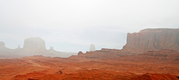
To the Navajo, Monument Valley, the first tribal park in the United States, is more than a park or nature preserve. It is one of the spiritual centers of their ancestral homeland, a living link to their culture and identity, quite separate from Ford’s mythic Westerns. Some visitors are drawn by the landscapes they remember from his movies, but Navajo guides instead share stories about the Holy Ones, healing ceremonies, rock art and their clans.

“When I am away from here for a long time and come back here, I always shed tears,” says Harry. “But they are tears of joy. It is my connection to who I am as a Navajo.”

Merrick butte
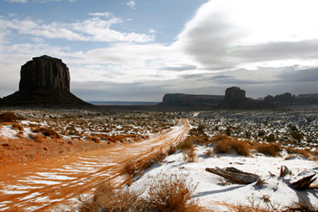
“Monument Valley has an unusual power that anchors us,” Garry explains. “There is an inner harmony, beauty and peace. Navajo and non-Navajo, who come here, have been healed emotionally and physically. In our history, no invaders could come in and conquer it.” This included the brutal ‘Long Walk’ of 1863-1864 when the U.S. army under Colonel Kit Carson invaded and forcefully relocated thousands of Navajo people to a New Mexico wasteland called Bosque Redondo. Many of those who escaped capture found refuge in the valley.

What I felt earlier, I now begin to understand. Without these marvels of stone, no Navajo stories of creation, legends, songs or cultural memory would exist. They offer a sense of stability and permanence, even though in the scale of geologic time, I know that they are anything but. But that is not the point. It is their meaning to us that matters.

Looking at the sheer, red-rock faces, I feel a living presence with the past. It is embedded in the rock art of the ancient Anasazi, the fossils of plants and animals, and the aquifer-rock formations that channel water to sacred springs.

The Three Sisters
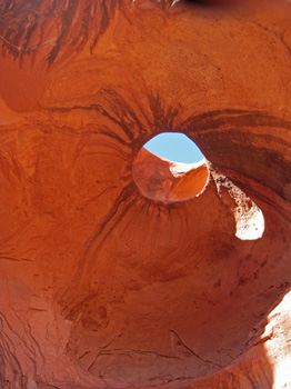
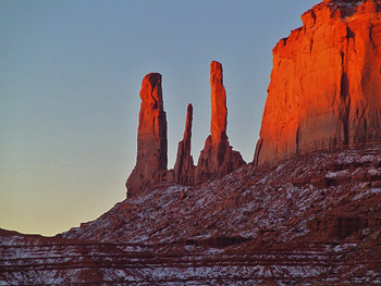
With its hidden burial sites and surreal rock formations infused with gods and spirits and the Navajo presence, Monument Valley is unlike any other place that I have visited. This becomes clear to me later when Harry, Dick and I drive to Ear of the Wind, a tunnel-like vaulted rock arch that opens up to the sky, where echoes from the wind can be heard. In my mind, it resembles a cave where a giant once stayed to watch his kingdom.

Harry motions to us to sit a short distance away beneath another arch called Big Hogan. He tells us that giants long ago came here to talk to the coyotes, rabbits and other animals about what would be best for the world.

While listening, I stare up at the vaulted sandstone walls stained with black streams of water called desert varnish. The narrow vent or hole at the top, beaming like a lantern of white light, casts a golden glow across the rock.

The Thumb
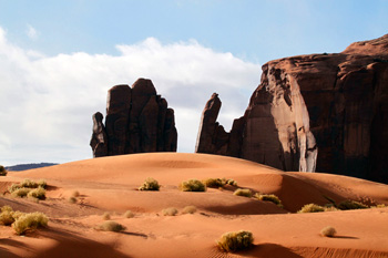
Then a long sonorous cry pierces the silence. Maybe fifty or sixty feet away, we see a young Navajo chanter sitting on a rock ledge. He breathes deeply and then leaning forward, rocks his body back and forth as his high-pitched voice echoes off the canyon walls.

I do not know what the chant in Navajo signifies, except that it is harrowing, full of sadness, perhaps about the ongoing drought, and then calming, soothing, perhaps reflecting his hope for rain to water the land again.

As I look up at the vaulted rock, the chanting softens as it drifts through the sky hole into the other world.

If You Go:

Getting There:

♦ Monument Valley is located within the Navajo Nation, 170 miles northeast of Flagstaff, AZ on the Arizona-Utah border. Farmington, NM and Flagstaff are the nearest municipal airports. Local airports exist at Monument Valley, Kayenta and Page, AZ; Cortez, CO and Moab, UT.

Getting Around:

♦ The best way to get to Monument Valley is by car. The park’s entrance is in Utah. From Flagstaff (178 miles) head east on I-40 to US-89 N and follow US-160 E to US-163 N. (Kayenta exit) to Monument Valley Rd. in Olijato Monument Valley. US-163 links to US-191 in Utah. From Farmington (156 miles), head west on W. Broadway, take US-64 W and US-160 W to Monument Valley Rd.

Attractions:

♦ Monument Valley is a magical place for photographers and other outdoor enthusiasts. Along with taking a half-day or full-day tour with a Navajo guide, visitors can stargaze, hike Wildcat Trail, visit the intriguing Valley of the Gods and Goosenecks State Park in San Juan County north of the valley, or drive the scenic section of US-163 to the historic town of Bluff, UT.

Accommodations:

♦ Overlooking the spectacular Oljato-Monument Valley, Goulding’s Lodge is an historic icon, famous for its association with director John Ford’s Old West movies. The museum, once Harry Goulding’s trading post, offers a glimpse into that bygone era. The lodge has a dining room, gift shop, cabins, campground and small theater where guests can watch Ford’s westerns.
♦ Adjacent to the park’s visitor’s center and Navajo-owned, The View Hotel provides breathtaking views of the valley floor, especially the Mitten Buttes. Along with a restaurant, campground and cabins, it has a trading post unlike any other that features Navajo jewelry, earthen pottery, woven baskets and one of the largest rug collections within the Four Corners.

For More Information:

♦ Monument Valley Navajo Tribal Park has information on fees, camping, and tours.
♦ American Southwest provides information on the landscape, accommodations, and the valley’s 17-mile dirt-road scenic drive.
♦ Award-winning Navajo Spirit Tours features a beautiful photographic expose of the land, the Navajo guides and tours offered by the company.


Monument Valley and Navajo Indian Reservation

About the author:
Victor A. Walsh spends his time when he’s productively unemployed prowling forgotten or unusual destinations looking for stories that connect a place and its people to their remembered past. His historical essays and travel stories have appeared in the Christian Science Monitor, American History, Literary Traveler, California History, Journal of the West, Rosebud, Desert Leaf, among other publications.

Photos by Richard Miller (1-7), Scott Laws (8) and Richard Miller (9)
West Mitten (L), East Mitten in the foreground, and Merrick Butte (R)
The vaulted sandstone walls of Big Hogan
The spiral-sculpted monolith called Totem Pole
Spearhead and Rain God Mesas cradle the distant spires of Yhe Bi Chei and Totem Pole
Ear of the Wind
Monument Valley veiled in a mantel of morning fog
Merrick Butte (L) on the historic route used in John Ford’s film Stagecoach
The Three Sisters
The Thumb surrounded by wind-tossed sand dunes

Tagged With: Arizona travel, Navajo attractions Filed Under: North America Travel

Florida: Vizcaya Villa

Villa Vizcaya

Italian Renaissance Gem in Steamy Miami

by Suzanne Ball

When people think of Miami, they picture sunny beaches, vibrant nightlife, art deco, and authentic Cuban food. But they often miss the chance to visit one of the country’s most historical mansions and example of Italian Renaissance style: Villa Vizcaya, described as “the finest private house ever built in America.”

Now called Vizcaya Museum and Gardens, the estate was the dream of millionaire James Deering, heir of the International Harvester fortune. One of America’s original “snowbirds,” Deering began planning his winter residence in 1910. He chose 180 acres of primeval jungle, a few miles south of Miami, directly on Biscayne Bay. He envisioned guests approaching and first seeing the Main House by water, and wanted it to be near the shore so they could disembark as if in Venice. “Place my house on the bay,” he directed the architect.

Venetian style barge and gazebo
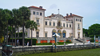
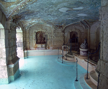
Vizcaya was designed with an open central courtyard, surrounded by four towers. Although the exterior duplicates 18th century Italian architecture, the building was constructed with 20th century techniques to adapt to Miami’s subtropical climate. Deering was a trained engineer and insisted on a concrete structure with steel-enforced floors to combat humidity, decay, and termites. He included modern features such as an elevator, telephones, and an “annunciator” to beckon servants from anywhere in the house.

Construction on the Main House began in 1914 and was ready for Deering on Christmas Day, 1916. During the height of construction, Vizcaya hired ten percent of Miami’s workforce, as well as craftsmen and artists from Europe. Witold Rybczynski, Professor of Urbanism at University of Pennsylvania, explains the level of detail involved: “There are thousands of craftsmen and workers and iron work and the [roof] tiles came from Cuba … there were old homes in Cuba and they bought the whole roof and shipped them over because they liked the sort of old patina on these clay tiles so it was a very, very thought out project.”

pool grotto
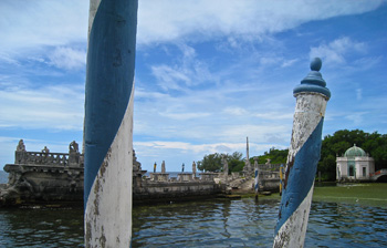
Deering was a renowned and extravagant host. His many guests included actress Lilian Gish, Henry Ford, and President Warren G. Harding. He placed a concrete barge in the bay and used gondolas or motor boats to transport guests for tea and cocktails. He also arranged for concerts and fireworks from the barge, and guests would watch from the shore. Originally, in true Venetian manner, the barge and gardens were accessed by canals. Deering would guide visitors through the canals, ending at the barge or the nearby gazebo.

Then there is the Main House. Over 38,000 square feet, with 54 rooms. Today, visitors can view 34 decorated rooms with more than 2,500 original furnishings and art collections. Each formal room has a theme, color palate and lavish furnishings, often based on different Italian cities or historical periods. On the main floor, Milan inspired the Music Room; Palermo provides a Southern Italy influence in the Reception Room. Deering’s bedroom is furnished in the masculine style of the Napoleanic era. Visitors are astounded at the opulence of this winter residence, meant to be inhabited from November till the start of Lent.

Enormous quantities of Italian antiques and artwork were shipped to Vizcaya, overseen by Deering’s artistic director, Paul Chalfin. Chaflin was fluent in Italian and an expert in Italian furniture and decorative arts. Upon meeting, Deering and Chaflin struck an immediate friendship that lasted until Deering’s death. Vizcaya would be Chaflin’s only significant commission, yet an outstanding legacy.

A lifelong bachelor, Deering installed many activities that could especially be enjoyed by male guests; the swimming pool featured a covered grotto that extended into the sunlight. Today’s gift shop and café were once a bowling alley, billiards, smoking, and changing rooms. During a 2011 renovation after Hurricane Wilma caused extensive damage in 2005, care was taken to maintain the original marble and terrazzo floors, copper lighting fixtures, and leaded-glass doors.

lower garden
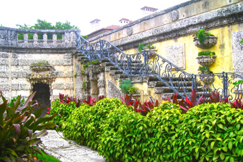
Deering also wanted formal European gardens, adapted to the Florida climate and flora. The garden design included Deering’s favorite flower, orchids, with 2,000 specimens placed throughout the estate, and now in the new David A. Klein Orchidarium. The gardens were completed in 1923. Deering would only live for two more years to enjoy his magnificent estate. Suffering from pernicious anemia for years, he died on a steamship returning from Paris in 1925.

The ten acres of formal gardens are spectacular and well-maintained. Local coral stone was used for stairs and planters, with influences from Florence and Rome. Reflecting pools and well-trimmed hedges are abundant. Statues from 18th century villas in Italy decorate the gardens, along with antique busts and vases.

Vizcaya is a popular location for photography, especially for bridal and quinceañera (the celebration of a Latina girl’s 15th birthday) events. It has also been the venue for political meetings, including the 1987 meeting between president Ronald Reagan and Pope John Paul II, and the 1984 Summit of the Americas hosted by President Bill Clinton.

2016 is the Centennial of this National Historic Landmark. In the humid climate, preservation of the Main House and its furnishings is ongoing. Vizcaya Museum and Gardens is now maintained by the Miami-Dade County.


Transportation to Vizcaya Museum and Gardens

If You Go:

♦ Viscaya Museum and Gardens is located at 3251 South Miami Avenue, Miami, FL 33129. Parking is free.
♦ From downtown Miami, Vizcaya is 2.6 miles, about 7 minutes. From Miami Beach, 11 miles, 21 minutes. From South Beach, 8.7 miles, 17 minutes.
♦ Hours: open daily 9:30 am to 4:30 pm, except Tuesdays, Thanksgiving, and Christmas.
♦ General admission is $18, with discounts for children, seniors, students, and military, and veterans.
♦ Accessibility: Vizcaya has limited handicapped access, due to the age of the building. There are many steps and uneven floors. Wheelchairs can use the original elevator; several ramps have been installed. Maps for access points are available.
♦ No photos or videos are permitted within the Main House. Visitors are welcome to take photos in the gardens and on the grounds.

About the author:
Suzanne Ball is a longtime freelance writer, specializing in travel and health topics. After walking the ancient 500-mile Camino de Santiago across northern Spain alone, she published an ebook to encourage other women and solo travelers to plan and pack for their own adventure. Other work has appeared in a Hilton Hotel magazine, Trip101, La Concha, and a variety of online websites and company blogs. Her personal blog was carried by the Seattle Post-Intelligencer. Suzanne loves it all: local, domestic, and international. She is a member of the International Travel Writers and Photographers Alliance.

All photos are by Suzanne Ball:
Main House overlooking Biscayne Bay.
Barge and gazebo, with Venetian posts
Pool grotto
Lower garden with coral stone steps and planters


Tagged With: Florida travel, Miami attractions Filed Under: North America Travel

  • « Previous Page
  • 1
  • …
  • 42
  • 43
  • 44
  • 45
  • 46
  • …
  • 72
  • Next Page »

MORE TRAVEL STORIES:

Crown Online Casino Australia: A Modern Crown Pokies Platform

Simplicity That Stuns: Your Essential Travel Wardrobe for India

Flavors of New Orleans in 24-Hours

Wales: Climbing Mount Snowdon

A Historian’s Pilgrimage to Canterbury

France: Quirks of Paris

Top 10 Street Food Experiences in Marrakech You Can’t Miss    

India: An Ode to Kolkata


SEARCH

DESTINATIONS

  • Africa Travel
  • Antarctica travel
  • Asia Travel
  • Australia travel
  • Caribbean Travel
  • Central America Travel
  • Europe Travel
  • Middle East Travel
  • North America Travel
  • Oceania Travel
  • South America Travel
  • Travel History
  • Travel News
  • UK Travel
  • Uncategorized
  • World Travel
facebook
Best Travel Blogs - OnToplist.com

Copyright © 2026 Cedar Cottage Marketing | About Us | Contact | Privacy Policy | Terms & Conditions | Copyright Notice | Log in