Travel Thru History

Historical and cultural travel experiences

  • Home
  • Airfare Deals
  • Get Travel Insurance
  • Writers Guidelines

Quebec City and the Twilight Zone

Frontenac's Battery Quebec City

by Troy Herrick 

It was déjà vu all over again and in my mind the voice of Rod Serling said “Your next stop, the Twilight Zone.” How would you feel if one day you were in the 17th century and then the next day you were at the same site but this time in the 21st century? Is this a psychic flashback into history you may ask?

This is exactly how it felt when Diane and I toured the movie set of La Nouvelle France (New France) and then followed that up with a visit to real Quebec City the next day. It is not everyday that you can stand in front of a reproduction and then see what eventually became of the real thing.

New France (La Nouvelle France)

Poof. We suddenly found ourselves standing at the river’s edge in early Quebec City between the years of 1608 and 1640. This location was selected as the set for the 1990 movie “Black Robe” because its landforms are similar to the actual site.

Fort St LouisOn July 3, 1608 Samuel de Champlain and 26 colonists sailed up the St. Lawrence River and landed in a narrow passage known as Kébec. Here they established a fur trading post consisting of three main wooden buildings, a wooden stockade and moat that they referred to as the “Habitation.” This was the origin of the Lower Town.

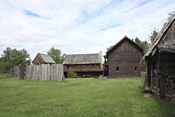
Near the river, you find replicas of several period houses, buildings and a trading post with all the necessities required for trade with the Indians including pots, pans and rifles. Aboriginal items obtained through trade included furs that had been bundled up for transport back to France and snowshoes for local use during the winter.

Carpenters and blacksmiths were kept busy in the colony with the construction of houses, buildings and defensive fortifications. The colony was highly dependent on these tradesmen and their homes have been reproduced here, along with the tools of their trade.

Ascending the rue (street) Côte de la Montagne to the Upper Town, Diane and I were greeted by a “Black Robe,” the Aboriginal name for a Jesuit priest, just outside Fort St. Louis.

Father Paul Menard, dressed in black cassock, invited us inside the palisade of Champlain’s 1620 fort. The first floor of the L-shaped two-story wooden building consisted of a large, well-stocked kitchen. A rifle hung from the wall just in case dinner happened to amble past.

Champlaign's headquarters
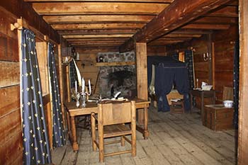
Champlain’s quarters, which he also referred to as his “habitation”, were on the second floor. His room had the finest furnishings on the whole set. A canopied bed and stone fireplace provided warmth during those cold winter evenings. A 3-pound cannon was placed in the corner near the window just in case undesirable guests decided to drop in for a visit like the Iroquois, the English or a mother-in-law.

Exiting the fort, we approached a wooden chapel, a replica of the first one constructed in Quebec City. The real chapel has since been replaced by the present-day Cathedral-Basilica of Notre Dame de Quebec.

Four wooden houses stand near the chapel. Father Menard’s single room home contains a wooden table with one place setting and several wine bottles for sacramental use only.

Approaching the baker’s house, you can imagine the smell of fresh crusty bread coming from the adobe oven outside.

The soldier/farmer’s log cabin was the most rustic of all with its wood and bark roof. Grass was stuffed between the logs for insulation. In case of attack, he had to drop everything at a moment’s notice, grab his musket off the wall and run to defend the settlement.

The occupation of the final home owner was not apparent. He may have been a merchant because the décor suggested he was a little better educated and well off financially.

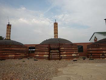
Our final stop was a Huron Indian Village. A section of a 16-foot high log palisade stood between us and the two longhouses inside. The narrow corridor at the front gate turned back upon itself so that only one person might pass at a time. This made it easier for residents to defend themselves against any enemy that might dare to enter.

The longhouses, approximately 55 feet long, 15 feet wide and 16 feet tall, were constructed of thin logs and sheets of tree bark.

Longhouse interior
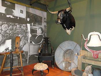
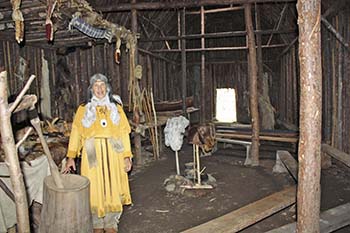
We entered one of the structures and found ourselves standing in a room permeated with the smell of wood smoke from the two fireplaces inside. We were greeted with the words “kwi kwi” (hello or welcome) from a Huron woman dressed in yellowish coloured animal skins.

She stood in front of a 3-foot high shelf, fashioned from tree branches, running along the length of the wall. The shelf served as a bed platform for the residents after it was covered with animal skins. This longhouse would have accommodated as many as 12 families (60 to 80 people).

The Huron people were farmers and fishermen. We were shown a hoe fashioned from a moose scapula tied to the end of a tree branch and a rake made from long animal bones which were also tied to the end of a tree branch. A few thrusting spears and harpoons with stone spear heads were also visible on the shelves.

After viewing the display, we thanked our hostess and then set off to visit Diane’s family in the real Quebec City.

Quebec City

The Lower Town

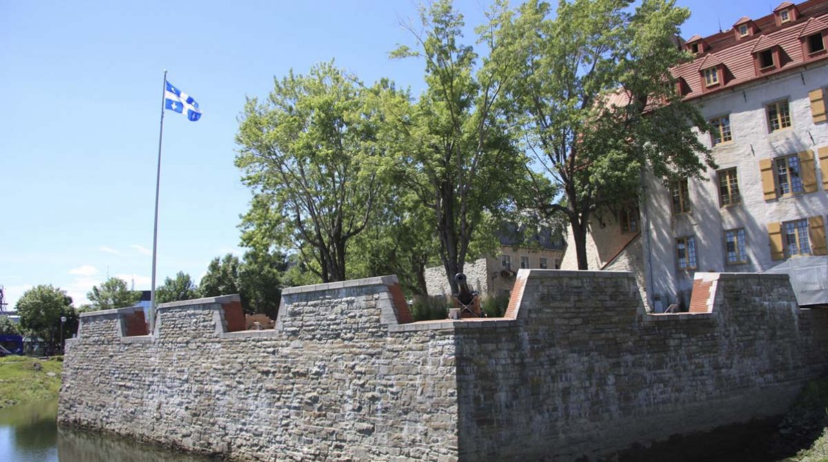
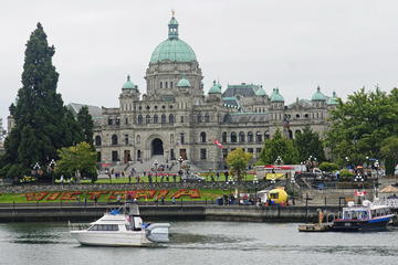
Poof. We suddenly found ourselves in 21st century Quebec City, a UNESCO World Heritage Site, standing atop French Governor Frontenac’s 1691 Royal Battery. This stone battery once served to protect the harbor with 10 cannons to welcome any unwanted visitors. [Photo at top]

Place Royale Quebec City
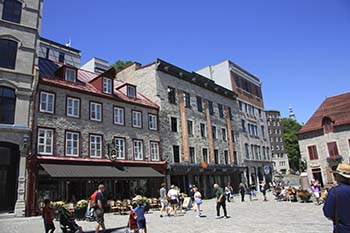
Our next stop was Place-Royale, a small square, that was once the site of Champlain’s original settlement. The Church of Nôtre-Dame-des-Victoires now stands on the site of Champlain’s first two habitations at Place-Royale; the first, a wooden structure erected in 1608, and the second, a partial stone structure built in 1624. Around the perimeter of the church, you find a series of black coloured tiles which outline the dimensions of Champlain’s second habitation.

Dating to 1688, the Church of Nôtre-Dame-des-Victoires is the oldest stone church in North America. Visit the interior of this church and then head over to the Place-Royale Museum, site of Champlain’s first trading post. When you exit the museum, make a point to stop and admire the large mural on the side of a building which depicts all the famous people associated with the city.

You may wish to wander around the Lower Town and shop for that perfect souvenir. When you are finished, it’s time to visit the Upper Town. You can either ride the funicular to the top or walk up the old windy road known as the rue Côte de la Montagne. Your walk includes the Champlain Steps, the oldest flight of steps in Quebec City. Feel free to catch your breath along the way and enjoy the spectacular view before you.
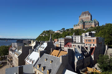
The Upper Town

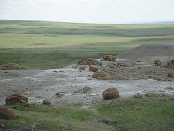
Standing near the Champlain statue outside the Chateau Frontenac Hotel, we enjoyed the picturesque view of the Lower Town and the St. Lawrence River below. We then descended a stairway through the nearby Dufferin Terrace and found ourselves standing on the foundations of Fort St. Louis. This was the site of a succession of four different forts and two chateaus, all constructed between 1620 and 1834. These had all served as the residence of both French Governors and several British Governors General during the colonial period. Champlain himself was responsible for constructing the first two forts, both wooden structures, in 1620 and 1626 respectively. The third fort, built in 1693, was the first stone structure on site. Champlain’s personal quarters were located beneath the pantry of a later structure.

Other findings from later periods include the remnants of a kitchen with a large brick bread oven and hearth, an ice house with a wooden grate at the bottom to drain the melt water and a coal storage shed.

Notre Dame de Quebec basilicaChamplain died on December 25, 1635 and was eventually interred in a chapel outside the fort three years later. This chapel burned down in 1640 and was ultimately replaced by the present-day Cathedral-Basilica of Notre Dame de Quebec. While the location of Champlain’s grave is still a mystery, Diane’s brother, Carl, noted that it was likely somewhere near the present-day cathedral.

Notre Dame de Quebec was the first Roman Catholic Cathedral constructed north of Mexico. As you enter the cathedral you pass beneath a stained-glass window over the front door depicting several Aboriginals. Inside, the apse showcases a statue of Jesus holding a large cross all set beneath several golden arches. A side chapel on the left houses the Saints Door which was gifted to the cathedral by Pope John-Paul II. This is the only holy door outside Europe.

Exit the cathedral through the front door and wander around the Upper Town. When you are finished you may wish to visit one or more of the local bars for a glass of wine. After passing through the Twilight Zone, Diane and I sure needed it.

If You Go:


QUEBEC CITY PRIVATE WALKING TOUR – 400 Years of French America

La Nouvelle France is located at 370 Vieux Chemin in St. Felix D’Otis near the City of Saguenay. Admission is $20.

The Church of Nôtre-Dame-des-Victoires is at 32 rue Sous-le-Fort.

The Place-Royale Museum is at 27 Place Royal.

The Chateau Frontenac is located at 1 rue de Carrieres. The Dufferin Terrace is right behind it.

The Cathedral-Basilica of Notre Dame de Quebec is at 16 rue de Buade.


Quebec City Helicopter Tour

 About the authors:

Troy Herrick, a freelance travel writer, has traveled extensively in North America, the Caribbean, Europe and parts of South America. His articles have appeared in Live Life Travel, International Living, Offbeat Travel and Travels Thru History Magazines.

Diane Gagnon, a freelance photographer, has traveled extensively in North America, the Caribbean, Europe and parts of South America. Her photographs have accompanied Troy Herrick’s articles in Live Life Travel, Offbeat Travel and Travels Thru History Magazines.

All photos by Diane Gagnon

Tagged With: canada travel, quebec city tours Filed Under: North America Travel

Celebrating Spring at Bear Mountain, Victoria

Bear Mountain spa Victoria bc

by W. Ruth Kozak 

What better way to celebrate spring than at an idyllic spa resort? A year ago I was fortunate to win a door prize at the BC Travel Writer’s Assoc. annual symposium. The prize was a two-day stay at the Westin Bear Mountain spa/golf course part of a resort community on Vancouver Island.

The community of Bear Mountain, located just 20 kms north of Victoria, began as golf resort but has developed into a multi dimensional urban resort community for people who desire a quiet and heathy lifestyle. Built on the slopes of a rugged yet pristine mountain area the resort not only includes the two par Nicklaus Design golf course, but also offers other amenities to the visitor.

The Westin Bear Mountain Golf Resort Spa is a luxury five-star hotel set in the midst of the urban resort development of Langford. It features spacious newly renovated rooms with expansive views of the golf course fairways and the surrounding mountains. The hotel has a private wine cellar, unique outdoor recreation areas including tennis courts, a Fire Lounge and free access to the North Langford Recreation Centre which is located between the two hotel buildings. Besides the hotel amenities and spa there are biking/walking trails and a golf practice facility. The golf courses features 36 holes providing a perfect experience for year round golfing with panoramic mountain and ocean views. You can always bring your lightweight golf bag to play some while staying there.

Bear Mountain golf courseI’m not a golfer but I was excited about going to visit Westin Bear Mountain to enjoy a Spring break. I arranged for a friend to come along, and then much to my delight I found out that the rooms accommodated four people. So I invited two other friends to join us. Because the invitation had to be used by the end of March 2018, I arranged for us to visit mid-March, a perfect Spring get-away after our long wet, west-coast winter.

We packed into one car and got the ferry to Swartz Bay and from there it was an easy drive up Island north-west through Langford to Bear Mountain. When we arrived and were given the room keys, imagine our delight when we found out that our “room” was actually a condo sized suite with a full kitchen, living room with a fireplace and balcony view of the golf greens, a large bedroom with a king-sized bed, and two bathrooms. The couch in the living room pulled out to make a double bed and the hotel provided us with an extra twin-sized cot for the fourth visitor.

The Bear Mountain village is a family friendly location with a Mountain Market nearby for shopping needs and Jack’s Place, a restaurant where we enjoyed several meals and entertainment. The Langford Recreation centre located between the two Westin hotel buildings, has a heated outdoor pool and offers year-round aqua-fit classes. The hotel’s award-winning spa services offer massages, body treatments and facials drawing from elements of nature to enhance your well-being, offering a full array of spa treatments, relaxation and renewal.

Recreation centre at Bear MountainWhile one of my friend indulged in a full spa treatment at the hotel, we others swam in the warm pool at the Rec Centre, enjoying the lush ambience surrounding the outdoors, and a soak in the hot tub.

Bear Mountain swimming poolThe area surrounding the resort is popular for bikers and hikers and the Rec centre provides bike rentals. We walked around the quiet trails that overlook the lush greens of the golf course, enjoying the quiet solitude of the woodland. One afternoon two of us decided to drive to Victoria to visit the museum, a quick and easy jaunt from the resort.

We couldn’t have enjoyed our weekend stay more. The Westin Bear Mountain Resort is an excellent get-away for all the family whether you’re a golfer or just want to relax and enjoy nature.


If You Go:


Victoria City Sightseeing Tour with Craigdarroch Castle

The Westin Bear Mountain Golf Resort & Spa, Victoria
1999 Country Club Way, Victoria BC  V9B 6R3
Toll-Free: 1 -800-WESTIN-1
Victoria: (250) 391-7160

North Langford Recreation Centre
Tel: 250-391-3758
Rec@bearmountain.ca
www.bearmountain.ca

On special holidays there is entertainment such as Bear Mountain Music, Halloween Festivals, Canada Day BBQ and the Bear Mountain Run, held for times a year.


Private Sightseeing Tour: Victoria & Butchart Gardens (13 hrs)

About the author:

W. Ruth Kozak has been an adventurer and travel writer for many years. She enjoys outdoor adventure experiences and travel to places like Greece and England but sometimes local trips are equally as enjoyable especially in the beautiful Canadian province where she lives, British Columbia, on the west coast of Canada.  Read Ruth’s blog.

Photos by W. Ruth Kozak

Tagged With: canada travel, Langford attractions, Victoria attractions, Westin Bear Mountain review Filed Under: North America Travel

Snowshoeing Through History in Gatineau

Sugar Shack, Gatineau

by John Geary

I could hear a familiar “Rat-a-tat-tat!” echo through the winter woods. Once I heard it, I stood stock still and listened, hoping to get a glimpse of the bird making the sound on a tree nearby.

Downy woodpeckerIt was dead-still, no wind, and the landscape muffled by a deep carpet of snow. I slowly turned my head around like it was on a swivel, trying to pinpoint where the sound was coming from. There! I spied it: a male downy woodpecker, tapping along a tree not far off the trail we’d been trudging along. I stood there watching it for several minutes, enjoying the bird’s sounds mixing with the gurgling of nearby Chelsea Creek that was not completely frozen over and the steady crunch-crunch-crunch of snowshoes biting into the snow along the trail as others of our group caught up or continued down the rail. I took a few minutes to snap some photos, then had to move on to keep up with the rest of the group.

We were spending a winter afternoon snowshoeing through woods of Gatineau Park, one of eastern Canada’s natural gems. Located not far from our country’s capital, Ottawa, just over the border in the province of Quebec, it’s a snowshoe aficionado’s dream, with roughly 60 km of trails set aside just for snowshoeing during the winter months, ranging from easy to difficult.

Often thought of as a sanctuary of nature and natural history – it is home to deer, beaver, black bear and nearly 230 bird species – the 36,000-hectare park lies in an area where the Canadian Shield meets the St. Lawrence Lowlands and where the Ottawa River meets the Gatineau River. In addition to its wonderful natural history, it also boasts a wonderful cultural history going back several centuries.

Author Katherine Fletcher writes of this rich history in her book, Historical Walks : The Gatineau Park Story, a wonderful resource to use to get the most enjoyment out of the park, whether you’re there in the winter, spring, summer, or fall.
We were there in winter, to spend an afternoon snowshoeing around the park’s trails, led by a park naturalist on a guided excursion. You can also do self-guided tours, but the first time you’ll often learn more if you use one of the park guides. They are well-versed in both the natural and cultural history of the park.

Just by choosing to travel the park by snowshoe is a choice to travel through history; snowshoes were used by the indigenous people of the area – the Anishinabe – whose history dates back some 8,000 years. It’s their footsteps we were walking in, breathing the air they’d breathed, hearing the same waterways they’d heard.

As several of our group had never been on snowshoes before, we were a bit limited in how far afield we could go during our tour. After getting outfitted with snowshoes in the visitor centre, we began our trip in the old “Sugar Shack,” with our guide telling about some of the history of the park.

Twenty minutes later, we were out on the trail, headed across Chelsea Creek over an old wooden bridge and onto the “Sugar Bush Loop.” The weather had been very good to us – just a few days before, it had been raining, but a cold spell quickly ended the rain and brought more snow to top what was already on the ground and almost-perfect weather for making like modern-day coureurs-de-bois (“runners of the woods”). Pierre Radisson and Médard des Groseilliers, step aside!

rabbit tracksWe were only on the trail about 15 minutes before our woodpecker friend showed up. Within another 10 minutes we saw signs of another of the park’s inhabitants: rabbit tracks. No sign of the bunny that made them, though.

We continued to tramp through the snowy woods for the next few hours, stopping from time to time as our guide pointed out or talked about interesting natural and cultural history aspects of the park.

Like many European settlers to North America, the first wave of immigrants from across the pond wanted to live by farming in the Gatineau area. However, the area’s rocky soil was not well-suited to agriculture, forcing them to turn to resource-based activities like hunting, fishing, forestry, and mining to earn a living from the land. Traces of homesteads and mines can still be seen in the park, today.

Although the fur trade was in full-swing during the early colonization of the area by the French and later the English in the late 17th, 18th, and early 19th centuries, the Gatineau area did not play a huge role as the trade developed into a large industry, for a variety of reasons: early on, the area was frequented by Iroquois and Algonquin tribes, so fighting often ensued between the traditional enemies.

Later on, location and size of the area rivers and other waterways – many which were too small for the bigger freighter canoes used by traders out of Montreal – saw them bypassed in favor of larger waterways, like the Ottawa River. (Interesting trivia point: a Gatineau family was involved in the fur trade – but they were based in Trois Rivieres a.k.a, Three Rivers.)

During the early 1800s, the area became very important for its timber resources, as the wood cut there went to build ships for the British navy. That continued for much of the century until changing technology reduced greatly the need for timber as wood gave way to metal in ship-building.

In the late 19th century, affluent residents in the Ottawa area began seeking outdoor recreation in the woods of the Gatineau Hills. Some – like William Lyon Mackenzie King – built cottages in the area. Some remains survive to this day, including remnants of the King estate, which grew from a simple summer cottage into an estate befitting a Canadian prime minister.

Of course, this was not a “park” officially until 1938, when the government began to acquire parcels of land and eventually turned it into the multi-use facility it is today, with historical, cultural, and natural attractions for visitors.

While we learned much of this from our guide during our tour stops, time prevented us from seeing many of the historic gems described, which were further afield in the park.

But that just provides an excuse to go back again, and spend time exploring the park and its history.

SUGGESTED SITES TO VISIT:

While I didn’t get a chance to investigate most of these in person, a few highlights you’ll want to try to see include…

The 231-hectare Mackenzie King country estate that belonged to Canada’s 10th and longest-serving prime minister.
The “Carbide” Willson ruins. Located at Meech Lake, the ruins of a generating station can be seen here.
The Sugar Shack; formerly located along the Sugar Bush Trail, now near the visitors’ centre, this is where we finished and started our hike. Built in 1972, it used to operate until cutbacks forced its closure. But it’s still a great place to warm up after an outing!

If You Go:

Getting to Ottawa from any major city in North America is not a problem; several international airlines service the international airport in Canada’s capital.

Gatineau Park’s main visitor centre and access to some of the trails is an easy 15 to 20-minute drive from Ottawa’s Parliament Hill.

Get on Autoroute 5 N in Hull, Gatineau from Wellington St/Ottawa 34, Portage Bridge and Boulevard Maisonneuve N. Follow Autoroute 5 N to Chemin Scott in Chelsea. Take exit 13 from Autoroute 5 N. Follow Chemin Scott to the park.

snowshoesIf snowshoeing, you can bring your own, or rent from the visitor centre. If you plan to rent – or if you plan to participate in a guided tour – contact the centre first to make you’ll be able to get shoes and a guide the day and time you want.

You may want to pick up a copy of the Fletcher book; it contains maps of the trails as well as a difficulty rating for each trail along with its comprehensive history of the park.

You’ll certainly want to check out the website ncc-ccn.gc.ca/places-to-visit/gatineau-park. Any contact info you need regarding use of the park can be found on that site.

You can also contact Tourism Ottawa.

The Friends of Gatineau can also be very helpful in planning your trip there – and they also offer some guided tours.

Other attractions you may want to visit while in Ottawa:

the Canadian Museum of History, located in the Hull area of Gatineau, again, very close to Ottawa.
the Canadian War Museum
the Canadian Museum of Nature

About the author:
John Geary is a full time freelance writer/photographer and social media manager with more than 30 years of experience working in broadcast, print, and digital media. He has traveled the world as a freelance travel journalist. He often focuses on birds and wildlife and paddling adventures in his travel writing.

Photographs by John Geary:
The Sugar Shack – where we began and ended our outing
Downy woodpecker doing its thing
Rabbit tracks! No sign of the bunny, though
Snowshoes are a great way to see the park in winter

Tagged With: canada travel, Gatineau attractions, Ontario travel Filed Under: North America Travel

Canada: 10 Reasons to Visit Medicine Hat, Alberta

Medicine Hat Tepee at night

by Darlene Foster

Medicine Hat, Alberta, is not often high on anyone’s must-visit list, if it’s there at all. But it should be. There are many reasons to visit this oasis in the Canadian prairies, here are ten of them.

The Name

Who wouldn’t want to visit a place with such a unique name? There are many stories about how the city acquired its unique name derived from the original First Nation’s name Saamis, which means The Medicine Man’s Hat. All the legends involve a feather headdress. One story tells of a battle between the Blackfoot and Cree in which a retreating Cree Medicine Man lost his headdress in the South Saskatchewan River at the place where Medicine Hat became a town. The city uses a feather headdress as its symbol. The locals simply call their town, “The Hat” and residents are often called, “Hatters”.

The World’s Largest Tepee

World's largest tepeeIt’s hard to miss this towering structure as you enter Medicine Hat on the Trans-Canada Highway from either direction. Originally constructed for the Calgary 1988 Winter Olympics, the Saamis Tepee is a tribute to Canada’s native heritage. The colours of the structure are symbolic, white for purity, red for the rising and setting sun and blue for the flowing river. It is the World’s Tallest Tepee standing over 20 stories high, weighing 200 tonnes and capable of withstanding 150 mph winds. The ten round storyboards inside the Tepee are hand painted by various First Nations and Metis artists depicting native culture and history. Each storyboard comes with a written description by the artist. There is something magical about standing inside the large open-air Tepee on a sunny, prairie day. It makes me realize what a rich cultural heritage my country has.

Medalta Pottery

Medalta pottery factoryThe city is blessed with clay perfect for making pottery, both functional and decorative. The pottery business once flourished in this century-old factory and its earthenware is renowned all over the world. The Medalta Pottery site has now become a museum, ceramic arts facility, art gallery and community hub where live music, markets and social events are held. One can wander the area and view the four huge brick beehive kilns, check out the museum and learn about the people and industry that helped make Medicine Hat. The gift shop sells replicas of the original pottery, made on site. No visit to Medicine Hat would be complete without a stop at the historic Medalta Pottery.

The Esplanade Arts and Heritage Centre

Esplenade museum displayIf you enjoy visiting the past, the museum located in this state-of-the-art facility is a delight. The displays follow the original First Nations People, to the settling of the west by Europeans, through the Second World War and the swinging sixties to present day. It really is a virtual walk through time. An ominous iron lung, a reminder of the polio scare from the early 1950s, will send a chill through you. Sepia coloured photo albums and audio recordings add to the experience. Besides the permanent display, interesting temporary exhibits can be viewed as well. An exhibition of women’s undergarments through the ages caught my attention on one visit. The centre is also a perfect place to take in musical and dramatic performances. Outside the building stands a bronze sculpture commemorating the German people from Russia who were instrumental in settling this area. I was proud to find my great grandfather’s name inscribed on the plaque.

James Marshall’s Sculptured Brick Murals

James Marshall sculptureJames Marshall is an internationally acclaimed Medicine Hat potter. He is renowned for his large-scale sculpted brick murals which can be found across Canada and overseas. Dozens of these murals are scattered about the city depicting its history and character. You will no doubt spot some as you make your way around. A splendid example of Mr. Marshall’s work can be seen at the Saamis Tepee as well as at the local Dairy Queen. A map from the Tourist Information office near the Saamis Tepee is available if you wish to take a self-guided tour to view these amazing works of art.

Red Rock Coulee

Red Rock CouleeAn interesting day trip to Red Rock Coulee, 56 kilometres (35 miles) south-west of Medicine Hat will not disappoint. This little-known area is a wonder to behold. Large, perfectly round, red boulders are scattered around a 324 hectare (800 acre) prairie landscape. Some of these boulders are up to 2.5 metres (8 feet) in diameter and are among the largest of these in the world. Virtually in the middle of nowhere, you will most likely have the place to yourself. It is like being on another planet! Research indicates these boulders were formed in prehistoric seas that once covered the area. Sand, calcite and iron oxide collected around a nucleus formed by shells, leaves or bones and grew as the circulating waters deposited more layers. The reddish colour comes from iron oxide. And I thought they were the result of a meteor shower! This is a great place to hike among the stones and view the prairie landscape. The only wildlife we saw were the resident mosquitoes which made us glad we brought bug spray.

 St. Patrick’s Roman Catholic Church

A prominent landmark in this city is St. Patrick’s Catholic Church. Inspired by the medieval cathedrals in Europe, it is said to be one of the finest examples of Gothic Revival architecture in all of North America. The church was declared a National Historic Site in 1990. Building began in 1912 and completed in 1914, with a number of renovations and improvements since. The amazing round rose windows, installed in 1955, were imported from France. New solid wood doors at the pointed-arch entrance were added in 1979. What is most striking is the copper roof affixed in 1977 covering the 170-foot twin spires that can be seen for miles. It is lovingly known as St. Pat’s by the local citizens.

Pioneer Village

Pioneer Village, located on the Medicine Hat Exhibition and Stampede grounds, is a collection of heritage buildings from the surrounding area including a general store, a church, a fire hall, a school and a blacksmith shop. Step back in time as you enter each building. The General Store is stocked with items from the past, with the original prices. Pails of Rodgers Golden Syrup, a ten pound tin for eighty-five cents, rest beside Aunt Jemima Pancake Mixes, and ashtrays in the shape of the legendary cowboy hat. How about a curling sweater or a wooden rocking horse? The yellowed calendar on the wall features Edward VIII and is dated January 1937. It’s like time stood still – or a Doctor Who episode.

The Farmer’s Market

If you are lucky enough to visit this fair city on a Saturday, a stop at the Farmer’s Market should be on your list. This is where you can stock up on local produce, farm fresh eggs, homemade jams and pickles, Eastern European delicacies such as perogies and mouth-watering desserts like kuchen; a pie-shaped coffee cake filled with custard, fruit and my favourite, cottage cheese. It’s best to come early as these popular items sell out fast. Tables of local crafts and art are available for sale as well. Stop by and visit with the friendly vendors who always have time for a chat. You will not come away empty-handed.

The Historic Downtown

downtown Medicine HatWalking around downtown, past replicas of the original gaslights that line the streets and huge trees planted a hundred years ago shading heritage brick buildings, you can relax and forget the hustle and bustle of large urban cities. Stop and play a game of chess on the large chessboard by the well-stocked library. The original Monarch Theatre, where kids in the past could watch a Roy Rogers and Dale Evans feature for twenty-five cents, still stands. There are many well-kept parks, overflowing with colourful flowers to wander around and contemplate life. Enjoy a coffee or a bite to eat at the many coffee shops and restaurants downtown, serving wholesome, homemade fare. The accommodating residents and shopkeepers, as hardy as the extreme weather, will answer any questions you might have and share a story or two.

So instead of driving through Medicine Hat on the way to somewhere else, or just stopping for gas and a Tim Horton’s double-double, stop and stay awhile. You’ll be glad you did.

If You Go:

Medicine Hat is on the TransCanada Highway, 296 Km (184 miles) east of Calgary and 465 Km (289 miles) west of Regina.

Air Canada flies into the recently renovated Medicine Hat airport.

About the author:
Darlene Foster is a dedicated writer and traveller. She is the author of a series of books featuring Amanda, a spunky young girl who loves to travel to interesting places such as the United Arab Emirates, Spain, England and Eastern Europe, where she always has an adventure. When not travelling herself, Darlene divides her time between the west coast of Canada and the Costa Blanca of Spain with her husband and entertaining dog. www.darlenefoster.ca

Do You Need A VISA To Visit Canada?
Get Canada VISA Information Here

Photo credits:
World’s largest teepee at night by Ken Eckert under the Creative Commons Attribution-Share Alike 4.0 International license
All other photos by Darlene Foster.


Tagged With: Alberta attractions, canada travel, darlene foster, medicine hat Filed Under: North America Travel

Walking and Paddling Through Goldrush History in Canada’s Yukon

Fort Selkirk Yukon sign
by John Geary

Walking across the grassy field to the Stone House Interpretive Centre, it was almost as if you could still hear people talking, going about their daily business as usual among the log buildings scattered around on top of the bluff overlooking the Yukon River.

Of course, no one had lived permanently at Fort Selkirk in the Yukon Territory since the 1950s, when the highway between Whitehorse and Dawson City went through. Prior to that, if you wanted to get from the territorial capital to the settlement, or further downriver to the city associated with the Klondike Gold Rush of the late 19th century, you had to use the river or fly in, once that type of transportation came into use.

The highway did not go anywhere near Fort Selkirk, located on the west bank of the Yukon River; at that point, the highway was several miles away over on the east side of the river.

Fort Selkirk homestead buildingEstablished as a trading post by the Hudson’s Bay Company in 1852, the fort evolved into a permanent community in the early 1890s. The gold stampede swelled its population and it became a base for both the Yukon Field Force and a Northwest Mounted Police post.

While it existed as a permanent community, both white and First Nations cultures worked and lived together amicably. That partnership remains today, as the Selkirk First Nation and Yukon governments co-manage the site.

Anyone doing a multi-day canoe trip on the river stops there, as there is a very nice campground for trippers next to the historic site. No matter what your paddling schedule, you’ll want to allow at least a few hours to explore the small museum and other buildings –a church, a store, residences, to name a few – to really appreciate it.

Fort Selkirk is just one of many amazing historical sites to visit in the Yukon.

And while not everyone will be up for a canoe trip to get there – or to Dawson City – you can drive from Whitehorse along Highway 2.

Dawson City really is a “living museum” with its boardwalks and clapboard-style of architecture in most of the buildings which are not residences.

Just strolling down the street looking for a place to enjoy breakfast my first morning there, I felt like I was walking in the footsteps of numerous sourdoughs (a word used for miners in the Yukon) … or maybe even in more famous footsteps – like those of authors Jack London or Robert Service, who both spent time there.

INTERPRETIVE TOURS

Dawson Daily News buildingParks Canada plays a significant role in keeping the history alive and making sure people have an opportunity to experience the site as fully as possible. One of the best ways to ensure you enjoy the full experience is to sign up for one or more of their tours at the Visitor Information Centre along the community’s Front Street, just a nugget’s throw from the river.

One of the first things I did was sign up for a tour that took us to the old post office, the newspaper office and a building that holds many of the archival materials dating back to the gold rush.

The tour starts off with everyone donning white gloves so as not to leave any oils or smudges on the artifacts you’ll be allowed to handle. There are several historical pieces located right in the visitor centre, and we warm up our “historical trivia minds” with some of these, as the guide prodded our curiosity by asking questions about the artifacts, testing our knowledge of the past at the same time.

Then it’s off to our next tour stop, a block or two away: the post office.

Robert Service book first editionApart from looking at the facility which used to handle all the mail coming into the centre of the Klondike gold rush, we had the opportunity to examine some more artifacts – including an original first edition book written by Robert Service.

This book – Why Not Grow Young? – was not one of poetry, though; it was a non-fiction book he’d written about healthy practices that would help you live longer. Robert Service – an early 20th-century Dr. Oz! Who knew?

After looking at some “old mail” packages and envelopes and some post office public notices on the walls, we headed down the street to the Dawson Daily News – or what used to be the city’s newspaper office and presses. After checking out the press equipment used to print the day’s news, we had the opportunity to read some actual newspapers that were published on the very day we were visiting – but back in the early 20th century. Very interesting reading about items like the “recent Wall Street slump” and news of the Kaiser from Europe (this was before The Great War, remember). Even the ads were quite interesting: white golf sweaters for women, travel ads for rail lines and steamships, and food ads for products like “Juicy Clark’s Pork and Beans.”

Our final stop took us to a building which houses several archives not on display in the other buildings.

LITERARY HISTORY

A brisk 15-minute walk from the visitor centre takes you to the Robert Service Cabin. Again, a Parks Canada interpreter helps make the experience come alive. Dressed in the fashion style that the poet of the Yukon would have probably been decked out in, stories and poems pour forth from the guide’s mouth, painting a picture of the man who went there as a bank clerk, but grew to become the creator of such famous verses as “The Cremation of Sam McGee” and “The Shooting of Dan McGrew.” I learned that he wrote much more than poetry about the north and the gold rush; he was quite prolific when it came to poetry about the First World War, as well.

After the presentation, we spent several minutes in his restored cabin (he lived in it from 1909 to 1912), which contains some of the original historic artifacts, including a writing desk, writing materials, tools, oil lamps, wood stove, telephone and his bed.

Log structure at Jack London MuseumA few minutes down the road from the Service cabin sits the Jack London Museum. It contains some pieces of the original cabin the American author stayed in during his foray into gold-seeking; half of the logs are here, the other half at a similar museum in San Francisco, where he lived in the U.S. The museum contains several photos and other memorabilia pertaining to London’s time in the Yukon, and a video display that continually rotates Hollywood movies based on his writing. An interpreter gives talks about his life at several times during the day.

While you’re in the neighbourhood, take a few minutes to take a quick look at the Pierre Berton home across from the Service cabin. A resident of the community as a boy growing up, the Canadian author was a big advocate of his hometown and its history.

PADDLEWHEELER ADVENTURES

SS Keno paddleboatAnother historic site worth checking out is the SS Keno. The old sternwheeler is berthed in a dry dock on the waterfront. Built in 1922 by the British Yukon Navigation Company, it steamed along transporting silver, zinc and lead ore down the Stewart River from mines in the Mayo district to the confluence of the Yukon and Stewart rivers at Stewart City. It was retired from commercial service in 1951, again because of highway construction.

Better still, why not take a step back into time and ride on a paddlewheeler like the old sourdoughs use to sail up and down the river on?

The Klondike Spirit cruises up and down the Yukon with several tours daily on most days from mid-May to early September. An interpreter explains what you see along the way; you’ll see a paddlewheeler graveyard, a First Nations community, and the spot where an old hermit used to live just upstream and across the river from the city.

DON’T FORGET THE NIGHTLIFE!

Before leaving Dawson City for other adventures, you’ll want to check out some of the nightlife that recalls the kinds of entertainment enjoyed by the sourdoughs. A trip to Diamond Tooth Gertie’s with its turn-of-the-century stage shows is a must-see.

SourToe Cocktail

Whether you check out the dance hall girls or not, you’ll probably regret not joining the SourToe Club before leaving Dawson. Go to the Sourdough Saloon and ask for Captain River Rat. Then you purchase a shot of your choice – rye whisky, rum, vodka, or as many choose, Yukon Jack. I opted for rye when I did it, as they were out of YJ.

Then you just take the “SourToe Oath,” watch as an actual dehydrated human toe is added to your drink, and cheers! Down it (the booze, not the toe!) and you’re in!

There’s an interesting story about how this tradition began, but I’ll let you discover just what that is when you go for your cocktail.

Just remember, there is one rule: “You can drink it fast, you can drink it slow, but your lips have gotta touch the toe!”

And look at it this way: your lips are touching a part of history. And isn’t that what this journey is all about?


If You Go:

Getting there

The starting point for any trip to the Yukon is Whitehorse. Both Air Canada and Air North fly in to the territorial capital regularly.

For planning your trip itinerary, start with the Travel Yukon website; it can give you lots of ideas and contact information to help you plan your trip:

From Whitehorse, you can either fly into to Dawson City or drive Highway 2. There are car rental agencies in the capital.

If you have a mind to canoe on the Yukon River to see Fort Selkirk, Up North Adventures can supply gear, food, and guides.

Other helpful links:

Klondike Spirit Paddlewheeler Cruises

Dawson City Visitor Centre

Parks Canada Klondike Historic Sites


About the author:
John Geary is a full time freelance writer-photographer based in Vancouver, B.C. He often specializes in stories that involve paddling and bird/wildlife watching but has always been an avid history buff since the fifth grade, when he heard tales of Marco Polo that kick-started his longing for exploration and adventure.

Photos by John Geary

  1. The edge of the Fort Selkirk historic site
  2. One of the homestead buildings at Fort Selkirk
  3. The newspaper office
  4. One of the artifacts in the post office: An original Robert Service book
  5. A food cache outside the Jack London Museum
  6. All aboard! The Klondike Spirit is getting ready to shove off


Tagged With: canada travel, Dawson City attractions, sourtoe cocktail, Yukon attractions Filed Under: North America Travel

  • 1
  • 2
  • 3
  • Next Page »

MORE TRAVEL STORIES:

Searching for the Monster of Lake Norman

Cliff Side Temple Tombs of Fethiye, Turkey

Reading for Henry VIII

Greece: An Inspiring Day at the Achilleion, Corfu

The Memorial Hall Museum

Holguín’s Best Kept Secrets: Off-the-Beaten-Path Adventures

Traveling To Nassau: Essential Safety Checklist For Road Trips

Cocoa Beach Florida: Sun, Swamp and Space


SEARCH

DESTINATIONS

  • Africa Travel
  • Antarctica travel
  • Asia Travel
  • Australia travel
  • Caribbean Travel
  • Central America Travel
  • Europe Travel
  • Middle East Travel
  • North America Travel
  • Oceania Travel
  • South America Travel
  • Travel History
  • Travel News
  • UK Travel
  • Uncategorized
  • World Travel
facebook
Best Travel Blogs - OnToplist.com

Copyright © 2025 Cedar Cottage Marketing | About Us | Contact | Privacy Policy | Terms & Conditions | Copyright Notice | Log in