by Noreen Kompanik
Most visitors to the Big Island of Hawaii are searching for volcanoes and waterfalls. But on a recent visit, we yearned to find out more about its fascinating history. To do this right, we had to step back in time searching for petroglyphs and ancient ruins.
Petroglyph Fields
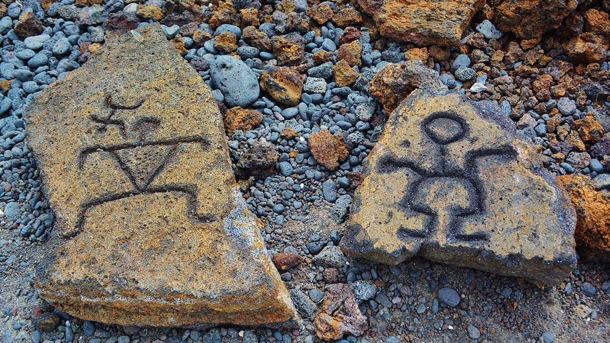
“Petroglyph” comes from the Greek words, petros for rock, and glyphein to carve. Hawaiians call this form of rock art k’i’i pohaku, or images in stone. Though petroglyphs can be found in at least 100 sites on all the Hawaiian Islands, the largest concentration of these mysterious carvings is on the Big Island of Hawaii.
Though the true meanings behind these ancient rock carvings dating back at least 400 years or more are unknown, it’s widely believed they commemorate a wide range of significant occurrences in the lives of the ancient Polynesian Hawaiians.
With early Hawaiians possessing no form of written language, these figures carved into lava rocks are thought to record not only births and parts of rituals, but also statements of place and other significant religious, social, and political events that occurred in their lives long before the native Hawaiians’ contact with western cultures.
Some of the petroglyph images are clustered near historic land boundaries or along footpaths cut through lava fields, but the full reasons for their location and cryptic creation may forever remain a mystery.
Our journey back in Hawaiian history began with one of the best preserved petroglyph sites on Hawaii’s Big Island—the Waikoloa Petroglyph Field on the western Kona side of the island. It’s believed Hawaiians settled this coast from 1400 to 1700 AD and going to and ventured inland to quarry stone for abrading tools. But some historians believe the island could have been visited as early as 1,000 AD.

 Petroglyphs were often left made as a recording of the ancient Hawaiian’s visit and a wide variation of these carvings were found intact within these craggy lava fields. Shallow caves thought to have been made as weather retreats are also found here. And this area, just a short distance from an upscale shopping center is the most accessible petroglyph field on the island.
Puako Petroglyph Archeological Preserve just a few miles to the north from Waikoloa is a 1.4 mile roundtrip trek in one the largest petroglyph sites on the Big Island.
Found just a short walk from the stunningly beautiful ocean-side Fairmont Orchid Resort, this site contains thousands of well-preserved etchings, some of oldest found on the island. The petroglyphs were discovered during the development of a golf course for the Fairmont. The area however was kept intact and the 233-acre preserve was respectfully established to protect these ancient Hawaiian remnants.
Carvings of humans, canoes, sailing ships, turtles, chickens and even family groups among other symbols are messages left in stone. Others show soldiers yielding weapons. One can only wonder at the messages they were passing on to future generations. Or if within these fields, the ancient Hawaiian mana still lives here.
The unpaved trail is accessed through a kiawe (thorny tree) forest. Signs are clear for visitors to never touch or climb on these ancient archeological treasures but explanations about the historically significant petroglyphs remain mysterious and sparse.
Other numerous petroglyphs are also located at the coastal end of Chain of Craters Road in Hawaii Volcanoes National Park. Unfortunately this area can be closed at times for safety reasons due to high levels of sulfur dioxide content in the air.

Hawaiian Village Remains
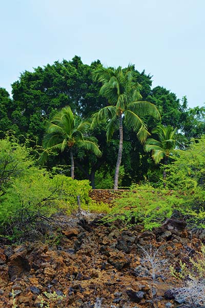
 For a fascinating self-guided tour of a historic Hawaiian village on the leeward coastline of Kohala, Lapakahi State Historic Park provides the chance for visitors to feel the winds of time and history blowing through this magnificent place.
As settlers sailed into magnificent Koai’e Cove some 700 years ago, they rejoiced at the opportunity to safely land their canoes. The rolling hills and gulches provided a rare sheltered cove from the strong Pacific winds along this rugged shoreline. The sea was rich in food and the soil nurtured their crops.
The ruins here are surprisingly extensive. Black stone walls and many remnants still fairly intact today cling to the hillside alongside a breathtaking seaside landscape.
Lapakahi was the place for fisherman and farmers. Though most families lived along the shore to fish, some moved inward to grow kalo (taro) and ‘uala (sweet potato).
Though there is no recorded history of the people here but what remains on the land helps cultural archeologists put some of the pieces of the puzzle together.
Trails through the Lapakahi village contain two loops. An interpretive brochure from the visitor’s center details the numbered markers along the path identifying the various structures, foundations and their purposes.
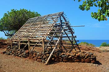
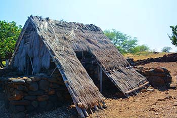 Of particular interest is the reconstructed Historic Hale or house site built with a bamboo frame, pili grass thatching and rounded basalt pebbled floor. The house was occupied into the early 1900s.
Hawaiian settlers dug wells, made their own salt, fished using the luhe’e lure made with a cowry shell and rock sinker specifically designed to catch the he’e (octopus).
A fishing shrine was built as a place to leave offerings to the Gods to ensure abundance from the sea. Mua, a family religious site was built for prayers and offerings.
 Stacked rock walls remain as remnants of a large residential complex. A Halua Wa’a was a thatch-roofed long walled enclosure to store canoes near the canoe landing. Of particular interest to us was a Papamu, a checkers-like game played on a stone board with black and white pebble pieces.
No one knows for sure when the walls of the village were constructed or the people who first journeyed to Lapakahi but one thing remains clear. They probably came for the abundance of the sea. And from its captivating bluffs, fishermen could watch the changing of the ocean and the presence and movement of the birds, fish and mammals that dwelled among them in their new abode.
 By exploring ancient archeological sites such as the petroglyphs and Lapakahi we can appreciate even more the Hawaiian’s intense belief that it’s past must be preserved for future generations to better understand who they are.
There are so many more sites to explore — and they call us to return on another day.
As they say in Hawaiian “E malama no keia mua aki (follow in the footsteps of those who came before). The journey to discover some of ancient Hawaiian history and culture was truly an experience we won’t soon forget.
If You Go:
2. Puako Petroglyph Archaeological Preserve
3. Lapakahi State Historical Park

About the author:
Noreen Kompanik is a published freelance travel writer and photographer based in San Diego, California. She is a member of the ITWA and IFWTWA and shares many of her adventures, stories and photos on her website whatsinyoursuitcase.net and What’s In Your Suitcase? Facebook site.
All photos by Noreen Kompanik
Waikola Petroglyph Field
Puako Petroglyph Archeological Preserve
Lapakahi State Historic Park
Reconstructed Hale at Lapakahi State Historic Park
Rock Walls at Lapakahi State Historic Park
Exterior Structure of a Historic Hale

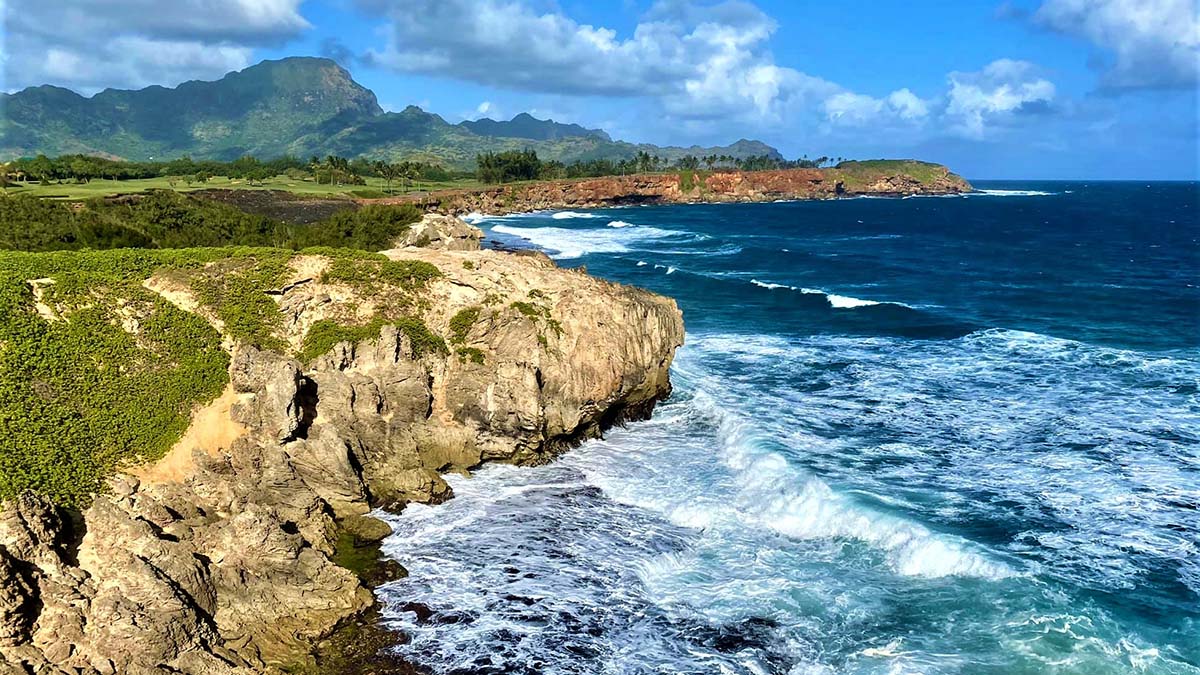
 Our hearts were set on introducing our fellow travelers to the spectacular Na Pali Coast, globally renowned for its rugged, breathtaking grandeur, secluded beaches, rainbow waterfalls and, yes, challenging, daunting hikes. Three days of heavy rains and flooding foiled our plans. Steep treacherous cliffs and slick trails make for heart failing excitement, but, not the kind of excitement we were looking for. Even under the best conditions the Na Pali Coast can be dangerous with its washed out trails and narrow, stony paths clinging precariously to the edge of cliffs. With more rain expected in the forecast, we reluctantly took the locals advice and headed south to the sunny shores of Poipu. It is here on the south side of Kauai that we found unexpected treasure.
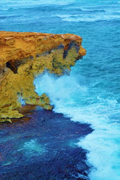 After climbing a gentle upgrade, we emerged into a completely different world. Greeted by azure skies and miles of crystal deep blue sea, the stunningly rugged coastline stood before us. Commanding views of the churning Pacific waters were visible from vantage points overlooking the edge of sun bleached cliffs. Magnificent coves in the distance appeared like a perfect painting. Blowholes shooting occasional sprays of salty ocean water along the path demonstrated the immense power of the ocean at high tide. Binoculars in hand, we ventured closer to the water, our excitement piquing with the unexpected sight of massive humpback whales breaching in the distance.
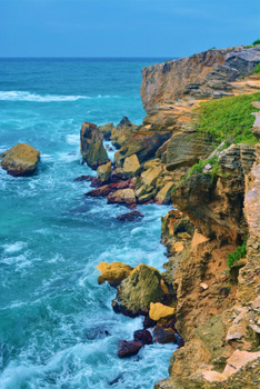
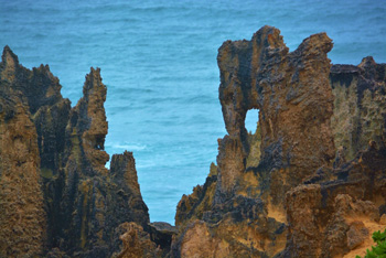 Each bend in the path yielded more surprise- the element of any good journey. Crystal clear tide pools teemed with tiny fish and miniature crabs all scurrying to find safety as each wave brought more water surging into the pool. Treasure troves of fossils and petroglyphs carved into the rocks line the coastal pathways. Skeletal remains of extinct birds that once lived on Kauai before Polynesian voyagers first arrived over 1500 years ago have been discovered by paleontologists.
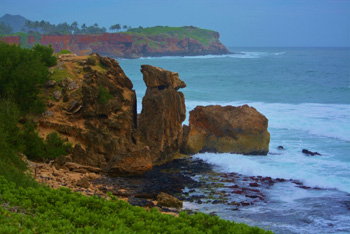 On our return trip, we followed the inside trail away from of the direct sun and into the welcoming shade of the palm and coconut forest. Since the paths split and merged repeatedly, we were able to easily navigate a completely different route back. Much to our surprise, we unexpectedly stumbled across a sacred ancient Hawaiian burial site. The stillness was interrupted by a gentle breeze stirring through the treetops, reminding us that for the ancient gods, their mana still lives here. Eyes closed, we sensed the spirit of the ancient Hawaiians and heard their whispers urging us to respect this sacred ground.
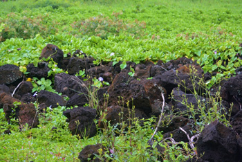 Arriving back to Shipwrecks Beach at the end of our trek, we were certain we could undertake this adventure multiple times and it would never be the same. Though not an exceptionally challenging hike, we instead experienced a relaxing trek with breathtaking views and fascinating discoveries perfect for a casual or family hike. Oh, and about that initial disappointment in forgoing the Na Pali trail, nature’s artistry took care of that.

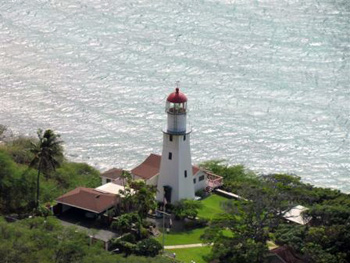 Fort Shafter is the oldest U.S. military installation on the island. Visit Quarters 5 residence of General Walter C. Short who was head of security on Oahu in 1941. Palm Circle which was strafed on December 7, 1941 houses the Pineapple Pentagon, Headquarters of the U.S. Army Pacific Command.
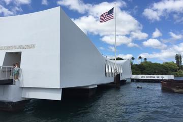
 Pearl Harbor Visitor Center/ Museum/ Battleship Row, the Arizona Memorial is probably the most visited site on Honolulu and begins at the visitor’s center with an outstanding film documenting the attack on Pearl Harbor, with actual footage of that day. There are informative displays to learn more about the events that took place that changed the course of American History. There are snack areas and food vendors where you can relax and grab a bite to eat. We met some of the survivors and were able to thank them for their service.
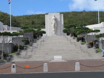
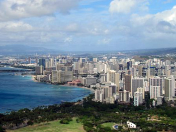 The Punchbowl National Memorial Cemetery of the Pacific is known to the Hawaiians as Puowaina or “Hill of Sacrifice.” This is the final resting place of over 35,000 Americans who proudly served their country. Experience the serenity of the Cemetery and discover the cemetery’s meticulously landscaped acres. There are also the Courts of the Missing, the chapel and the finely detailed mosaic maps of the Pacific theaters of action in World War II.
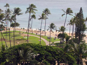 Waikiki Beach meaning (pouting fresh water) in Hawaiian in Downtown Honolulu is probably one of the most famous beaches in the world with it’s the white sand beach. The area of Waikiki is home to public places including Kapiolani Park, Fort De Russy Military Reservation, Kahanamoku Lagoon, Kuhio Beach Park, and Ala Wai Harbor.
 Between the months of November and February are the best times to watch the more experienced surfer’s battle the big waves that can reach up to thirty feet. However from May to September the waves are smaller and more tranquil for beginning surfers and excellent for swimming and sunbathing. There are fifty one beaches on the North Shore some of the more famous include Waimea Bay, Sunset, and Ehukai (home of the Banzai Pipeline) and have thick white sands that stretch for more than eleven miles.
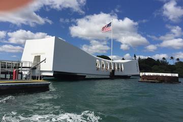


 Today, the old general store and social hall far below are barely standing, my family’s house still sits proudly high atop a hill and the old mill remains were finally taken down this past year. Paauhau remains a peaceful residential enclave for those who have chosen this exquisitely beautiful, quieter lifestyle.
 Having once played the role as a classic plantation region in the early 20th century, the Hamakua Coast has needed to diversify its economic base with the closure of many plantations. With much of the area still zoned for agriculture, additional crop offerings now include pineapples, coffee, papayas, macadamia nuts and tea.
 With a treasure trove of historic buildings still lining the downtown sector including the Honokaa People’s Theatre and Hotel Honokaa Club, Honokaa was once a popular hangout for thousands of WWII Marines and soldiers stationed nearby and a bustling commercial center for the sugar mill camps of Haina, Kukuihaele, Paauhau, Kapulena, and New Stable. It’s also where my grandmother once taught school and where my parents were married back in the 1950s.
 Continuing south, Hilo’s Sugar Plantation Museum is intriguing, authentic and informative. Recently relocated from downtown Hilo and up the Hamakua Coast a few miles, it’s now located in the old Papaikou Plantation Store and is now in the midst of reopening. With a family history so richly ensconced in the region’s sugar plantation legacy, we are granted our own personal viewing and tour the museum one afternoon. Still in the process of being refurbished, photos, home décor, carvings and vintage signs adorn the walls and display cases. This place is truly a step back in time to plantation life and a well-deserved restoration of an entire lifestyle once found throughout the region.
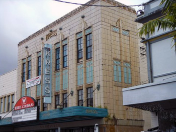 Heading into several antique stores is also synonymous with revisiting the area’s intriguing past. Authentic Hawaiian shirts, books, ukuleles and vintage record albums line the crowded aisles. There’s a dignified serenity throughout this town that honors a long, rich history. Art Deco buildings still bearing the names of original stores, including Kress and the Palace Theatre, rise high above the friendly, local streets below.


_-_Pu%27u_O%27o_Trail_-_Big_Island_-_HI_-_2015-11-06at15-07-451_(22419194588).jpg)
_Palilia_Discovery_Trail,_Mauna_Kea,_Big_Island,_HI.jpg)
_Hosmer_Grove,_Haleakala_Nat_Park,_Maui_co,_Hawaii.jpg)