by Bani Amor
When Túpac Yupanqui lead his Inca army through the cloud-swept Andean highlands toward the fertile valley natives called Guapondeleg, (‘Plain Wide as the Sky’) he was met with the unexpected and now legendary resistance of the fierce Cañari tribe, the tribal confederation of indigenous communities who had long-inhabited the area. Tupac, the 10th and arguably most powerful of Inca conquerors, was forced to retreat south where he sent for 100,000 more soldiers from the capital of Cuzco and re-evaluated his plan to subjugate the righteous Cañaris, eventually attacking again with stronger force, marrying a Cañari princess and thus seizing power over the region by 1470.
 To celebrate his victory, Túpac Inca Yupanqui (whose name meant ‘noble Inca accountant’) began to build a beautiful city there that would rival Cuzco as the heart of the Inca empire, a city that two generations later would be subjugated by the Spanish in their quest for the mythical land of El Dorado, the city now known as the colonial gem of Ecuador: Cuenca.
Growing up in thin-walled New York City apartments covered in tapestries, paintings, statues and other mysterious objects all weaving a colorful story of my family’s indigenous Ecuadorian roots, I revered the warriors-past as superhero-like titans that discovered everything first and knew it all the best. Years later, (having long chopped off my braided hair that is signature of the native feminine of Ecuadorian culture, and since pierced my broad Andean nose) I landed in ‘the motherland’ with hopes to gain a deeper insight into the history of my ancestors, and Cuenca could not have satisfied my curiosity more.
Cuenca is a modern-day mix of indigenous culture and colonial architecture nestled in the lush subtropics between snow-peaked volcanoes, lending its year-long moderate climate and awarding it as a UNESCO World Heritage Site and the top retirement destination today. Its mostly mestizo population of 450,000 live in short edifices that roll over hills and valleys in bright pastels and the common sight of church domes or steeples punctuating their landscape.
As I walk through the city’s narrow sun-drenched streets I peek into tall open doors of haciendas all lined with vines enveloping shiny, vintage Volkswagen beetles of every shade and, caught up in such lovely distractions, would stumble on the crumbling cobblestone – often. Such an occurrence is common in Cuenca, as is old men in llama-wool ponchos and fedoras walking beside men in business suits smelling of cologne and young punk women in combat boots; as common as the afternoon rain or church bells or flower markets that flood the boulevards; these are just a few glimpses of the people that have inherited the Inca empire’s crowning jewel.

 Its namesake is the city in Spain meaning ‘basin made by a confluence of rivers’, where the Viceroy of Peru at the time, Andrés Hurtado de Mendoza hailed from. He commissioned the founding of the city in 1557, which grew in independence and importance during its colonial era and reached its peak during first years of its independence, which was won on November 3rd, 1820. It later on became the capital of Azuay province in the center of the southern highlands, and is now the third-largest city in the country.
The confluence of rivers boasted by its name are the Tomebamba, Yanuncay, Tarqui and Machangara, the first three of which flow from the melted glaciers of nearby Cajas National Park, known locally as the ‘Land of 1,000 Lakes’. The main Rio Tomebamba was the city’s Quechua name before colonization changed it to Cuenca; Quechua being the still widely-spoken language of the Incas. Roughly translated as ‘Plain of The Knife’, the title may allude to the bloody feud waged over the land. Today its grassy riverside serves as a popular public spot where young students drink beer and old women dry clothes, sometimes employing their wrought-iron balconies that overlook the river on Calle Larga.
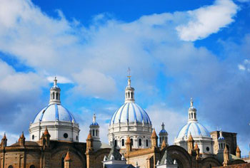
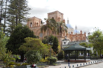
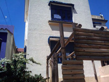
Cuenca’s most treasured architectural claim to fame is the neo-gothic New Cathedral of Cuenca whose cerulean cupolas have become the symbol of the city. German builder Juan Bautista Stiehle began drawing it up in 1880 but the project would eventually delay nearly a century to be completed. Now that it is, the Catedral de la Inmaculada Concepción’s alabaster facade stands opposite the Old Cathedral of the city (which had been outgrown by the locals), muffled in the middle the leafy plaza of Parque Calderon. The blue domes of the church are laid out in glazed Czechoslovakian tiles with pink Italian marble glossing its floors which are graced daily by the city’s faithful and foreign admirers alike, who travel from far and wide to praise a higher power or just the glory of the church itself.
 Another important historical landmark (but more exciting than it sounds) is the Iglesia de San Francisco, a neoclassical church built around a slender tower with an apricot-colored, horizontal base and mullioned windows that was built by Franciscans and finished in 1930. It is the best example of the baroque style in Cuenca and represents a harmony between baroque and neoclassical features, with a cedar altarpiece at its center. It’s situated at the edge of the expansive Plaza San Francisco which allows visitors views from many different angles, as the plaza has long-since been occupied by a popular, sprawling market where one can buy anything from alpaca backpacks to plastic Disney ones.
Cuencanos themselves are generally laid-back, open and proud citizens of their city. Nearly everyone I meet takes to rambling endlessly about the unique culture, sights and natural beauty of their hometown; one woman, after having traveled to such places as Italy and New York, lectures me on how the best pizza in the world is made in Cuenca. Her husband calmly backed her up, “ I’ve been everywhere,” he says, pointing straight into the ground, “and this is the best place in the world.” I can’t argue over the legitimacy of their statements, instead I view them as endemic examples of the modern-day Cañari attitude: a joyful and peaceful inheritance of their fertile plain ‘Wide as the Sky’ and as precious as gold.
Ingapirca Archeological Site and Cuenca City Tour
If You Go:
♦ Cuenca enjoys a mild climate year-round with the dry season between June and December and the rainy season between January and May.
♦ Mariscal Lamar International Airport offers daily flights to and from the metropolises of Quito and Guayaquil, as well as other neighboring countries. Local and inter-provincial buses operate out of the terminal terrestre, a brief walk or taxi ride from the center.
♦ Pumapungo is a pre-Columbian archaeological site located behind El Museo del Banco Central ($3 admission fee) in the center of Cuenca.
♦ The largest known Incan ruins in Ecuador are called Ingapirca and are actually Cañari in origin, whose matriarchal believers built a temple to the moon. Its remains sit near the rectangular sites of the Inca and their temple to the sun. Buses leave from the terminal in Cuenca daily and are about an hour-long ride. Entrance to the park is $6. Most tour companies in the city offer day trips to the site.
♦ El Cajas National Park is about 40 minutes from Cuenca and contains about 270 lakes and lagoons hailing from the Ice Age. The park is cut by both the Continental Divide and the Inca
♦ Trail and boasts an exotic array of birds, as well as llamas, wild horses and pumas. Guides are recommended but not totally necessary.
♦ The New Cathedral of Cuenca is hard to miss, located at Mariscal Sucre and Benigno Malo in front of Parque Calderon; free.
About the author:
Bani Amor is a queer travel writer from Brooklyn by way of Ecuador. At 15 she left high school to travel Asia, South America, Canada and the U.S. She lives in Quito, Ecuador with her cat, and writes Everywhere All The Time.
Photo credits:
All photos are by Bani Amor except #2.
1. The New Cathedral of Cuenca
2. Sketch of Tupac Inca Yupanqui from Appletons’ Cyclopædia of American Biography, v. 6, 1889, p. 180; public domain.
3. The Cathedral’s Entrance
4. Iglesia de San Francisco
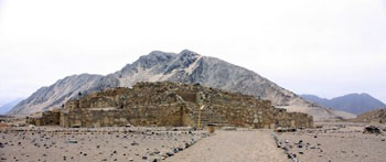
 Caral, an abandoned city eroded by time and windswept sand, holds twenty-five structures including six pyramids that are as old as the Step Pyramid in Egypt. More remarkably, this early civilization developed in complete isolation without the use of pottery, metalwork or writing, unlike its contemporaries in the ancient Near East.
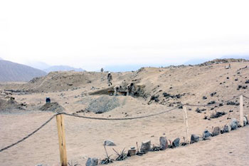
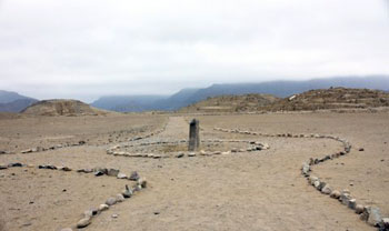 Just across the plaza, the Huanca Pyramid, named for the nearby 2.15 meter high huanca stone whose edges are oriented to the cardinal directions, holds three rooms atop its 12.8 meter summit. These rooms may have been used for astronomical and ceremonial purposes.
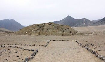 En route to our next destination, the Greater Pyramid, I fought back a sneeze as a sudden gust of wind raised a cloud of dust. Seen through the haze, the Greater Pyramid is the largest structure on site covering approximately four football fields. From a height of 19.27 meters (seven platforms), city officials oversaw all of the activities within the city.
 After making quick stops at the Lesser Pyramid, Quarry Pyramid and Central pyramid, we returned to the lower section of the city to visit the Temple of the Amphitheater. Julio directed us to a bank of twelve cubicles lining the entry platform that once held the remains of burnt food offerings.
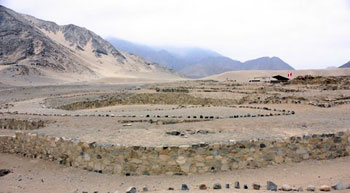 Deeper inside the temple complex is the Altar of the Sacred Fire. This cramped round space houses an altar with a two-level fireplace; an air duct runs beneath. This room was likely used for mysterious ceremonies that the general public was not privy.
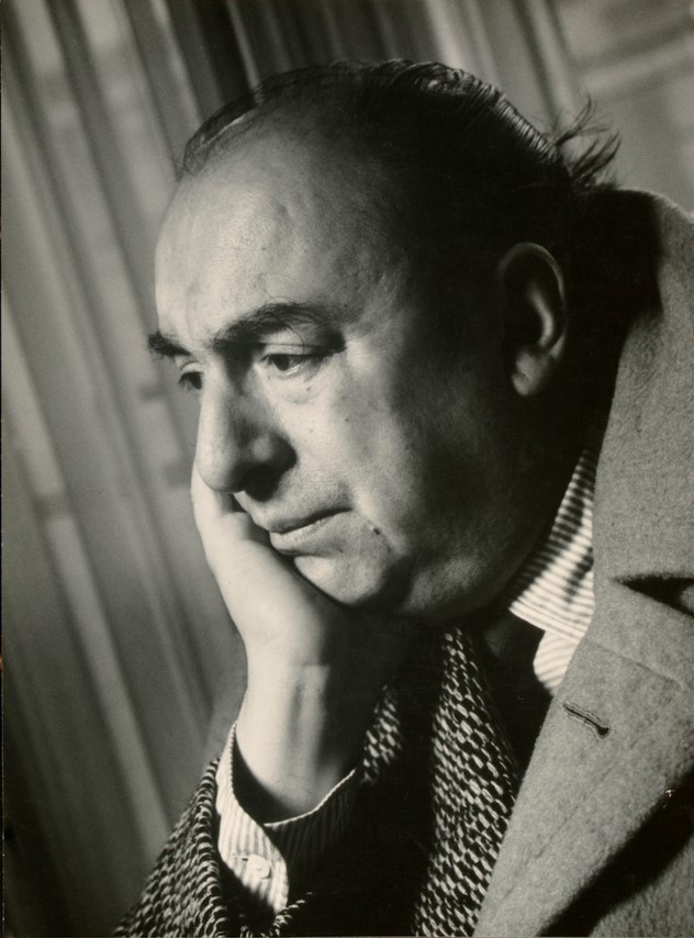
 It wasn’t difficult to find the poet’s house, La Chascona, on a little back street set on a hillside overlooking the city. “La Chascona” means “wild hair” and the house is named after Matilde, his third wife, who had a tumble of unruly tresses.
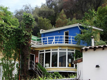
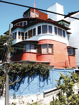 On the coast at Valparaiso, the second of Neruda’s houses, La Sebastiana, is set high on one of Valparaiso’s many steep hills commanding a view of the harbor. I took an ascendor from Espirito Santo up Cerro Bellavista where the house is located. I wended my way through the maze of narrow lanes, past a colorful hodge-podge of houses and eventually found the poet’s house.
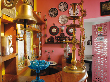 Neruda’s living quarters were on the second floor, ascending several floors up to the top room which was his study and lookout, with a broad spectacular view of Valparaiso’s harbor and the ocean. Each room in the house is full of the usual trinkets and beautiful knick-knacks he loved to collect. There are some lovely stained glass windows. You are allowed to wander around at will. Visitors are given booklets to read describing the history of each room and the furnishing and objects although no photographs are allowed other than the many breathtaking vistas from the windows.
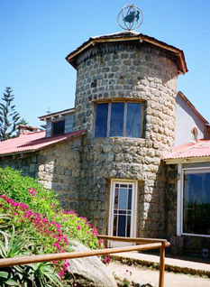 I took a bus down the coast to Neruda’s house at Isla Negra, which isn’t really an island. The house is built on a rocky headland overlooking the Pacific close enough to the shore to give that effect. The original stone buildings were erected in the late ‘30’s and were completed in the 1950’s. Neruda added to it bit by bit including various rooms to hold all his eccentric collections.
 During the junta, when Neruda was dying of cancer, the military stormed the house, but it has been mainly preserved just as it was, intact with his marvelous collections (even more fantastical than those at La Chascona). It is exactly as it was when Neruda and Matilde lived there, even to the place settings at the dining room table: place mats of sailing ships and one (the captain’s) of nautical instruments.
 As in the other houses, there’s a well-stocked bar where Neruda played the role of bartender. I can almost imagine him standing there, pouring drinks as he engaged in jolly banter with his guests. And outside, beached on the shore, is a small boat where he would also entertain. (The boat never went into the water!)
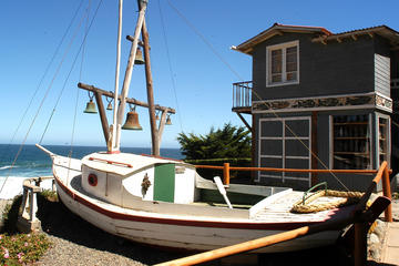
 Spanish Uruguay has two locations– one in Montevideo and one in Atlantida. Since I was no longer interested in the nonstop action that characterizes the city life, I chose the enchanting coastal town of Atlantida. Pablo, the son of the lead professor, sent me photos of two living locations. One was a high rise near the beach, the other was a small, enchanting apartment complex called Isla Negra.
 Isla Negra was one of the many one of the many houses belonging to Pablo Neruda, a romantic poet who writer Gabriel García Márquez referred to as “the greatest 20th century poet in any language.” His passion for politics equaled his capacity for love.
 In her book titled
 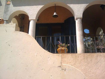 The gardener was a good friend of Neruda’s driver, Manuel Araya, who was the only person who knew about Pablo’s dalliances. In her book, Matilde states her suspicion that the driver gave the gardener some ammunition by telling him about Pablo’s mistress, which if course, got back to Delia. Pablo and Delia divorced, and Matilde and Pablo eventually became husband and wife.
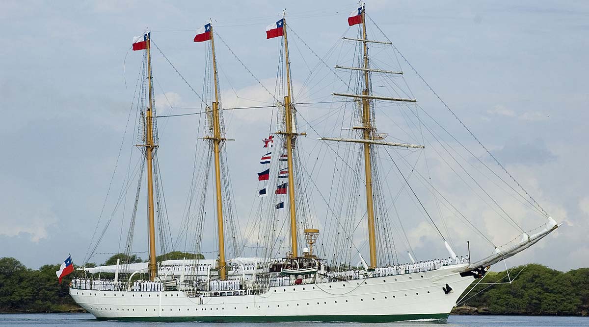
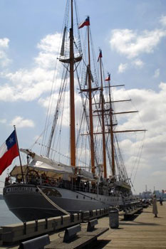 La Esmeralda, a stately four-masted barquentine, pride of the Chilean Navy, was built in Cadiz, Spain in 1946 and was to become Spain’s national training ship. Due to several explosions at the shipyards, work was halted and eventually she was sold to Chile to help pay off debts incurred as a result of the Spanish Civil War. She was officially launched in 1953. Esmeralda is now a training ship for the Chilean Navy, visiting ports worldwide as a floating embassy for Chile.
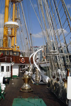 Unfortunately La Esmeralda’s reputation was sullied during the infamous Augusto Pinochet regime from 1973 to 1980 when she was used as a floating jail and torture chamber for political prisoners. The Chilean Navy was the advance guard of Augusto Pinochet’s coup and after the overthrow of Salvador Allende’s democratically elected socialist government, naval patrols scoured the streets of Valparaiso broadcasting the names of people demanding them to hand themselves in. Among them was an Anglo-Chilean priest, Father Michael Woodward. He was arrested at his home by a naval patrol and taken to the headquarters of the local Carabineros where he was brutally assaulted, then transferred to La Esmeralda where he was reputedly tortured and died. Doctors claimed he had died of a heart attack and the navy refused to give him a proper burial but dumped his body in a mass grave. Michael Woodward was one of the most prominent of those tortured on the ship. Several hundred other detainees, sympathizers of the ousted socialist president Allende, were taken there and suffered various fates including beatings, sexual assaults, electrocution and water torture. Consequently these days when she sails into port, crowds of protestors – political groups and Chilean exiles –gather demanding retribution in the form of a formal apology from the Chilean government and request that a plaque in the shape of a dove be put on the ship bearing the names of the victims. To date, these requests have been refused.
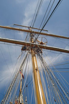 The ship itself truly is a beauty, a four-masted tall ship, one of the tallest and longest ships in the world. She has a crew of 300 sailors and 90 midshipmen, 46 of them women. Marcia, one of the lovely young female officers, took my friend and I around on a tour of the deck area, and explained the functions of the various pieces of equipment on board. The ship is spotless, the wooden decks polished and unmarred, the brass fittings shining in the afternoon sun. She pointed out the 21 sails and explained how every morning at 6 a.m. the trainees must climb to the top of the centre mast. If they falter or make a mistake they must do it again at noon. And if they make a bad error they must climb it again and again to get it right. She showed us the tasks she is responsible for every day as well as climbing up to secure the sails, although being a tall girl she only has to go part way up to do that. The shorter crew members are the ones who climb to the very top, a daunting job that not many people would have the courage to participate in.

