British Virgin Islands
by Noreen Kompanik
 The British Virgin Islands are home to a mystifying geological wonder commonly referred to as “The Baths”. Framing the aquamarine waters of the Caribbean along a pristine, white sandy beach, the Baths invariably evoke an astonishing, jaw-dropping reaction from all who visit this grand feat of Mother Nature.
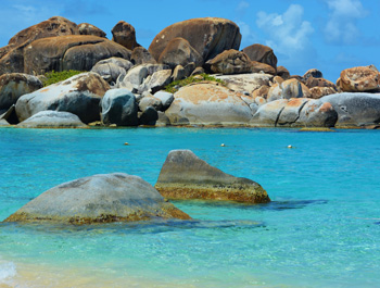
Located on the island of Virgin Gorda, the Baths (short for batholiths) are comprised of a labyrinth of massive, awe-inspiring granite boulders that form an amazing array of cavernous passages meandering through sheltered sea pools along a sun-drenched shoreline.
 The granite-type rock formations and fascinating topography is the artistic creation of millions of years of geologic and geomorphic activity. The batholiths were formed during the Tertiary period by molten rock under immense pressure, seeping up into existing volcanic rock layers under a young Caribbean Sea. Unable to reach the surface, the seething hot molten rock slowly cooled underwater, forming a hard crystalline granite layer. Further shrinkage and cracking formed enormous blocks, exposed when the softer volcanic rock above eroded away. Once the batholith reached sea level, physical and chemical weathering rounded the sharp edges of these granite blocks, creating their unique boulder-like appearance.
Over millions of years these massive boulders continued to be shaped by the flowing water from rhythmic crashing waves and further seismic activity. These actions have forever etched the power of nature and the passage of time on the faces of the jumbled rock formations.
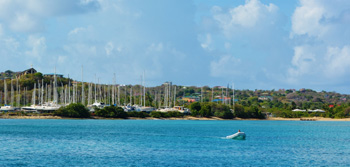 Sailboats and stretches of palm-fringed beaches with sugar-white sand came into view as our small boat, on a day trip from St Thomas, traversed the turquoise waters entering Virgin Gorda Yacht Harbour and Spanish Town. Covering only eight square miles and sparsely inhabited, this third largest of the Virgin Islands is a sleepy, idyllic Caribbean hideaway where goats and cattle own right away over island traffic. The name, given to the island by the explorer, Christopher Columbus is Spanish for “Fat Virgin”, because to these sea-weary mariners, the island’s profile on the horizon somewhat resembled a voluptuous woman lying on her side. A 10 to 15 minute open air taxi ride from the port transports island guests on a scenic slightly uphill drive to the southwest entrance of Baths National Park, a seven acre protected nature preserve.

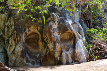
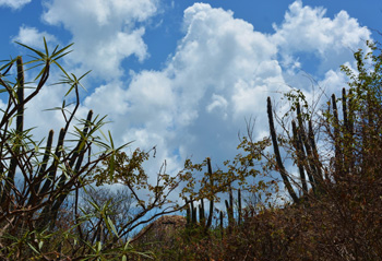 A winding, descending path of hardened sand from the park’s entrance leads visitors downward through an arid, desert-like landscape lined with scrub vegetation and multi-hued and shaped cacti. An intriguing rock formation known as The Skull appears like a ghostly pirate sculpture, but no human hands played a role in its creation. Rather this unique and startling formation is an eerie but interesting example of natural weathering causing large dishes and holes that comprise the skull-like face.
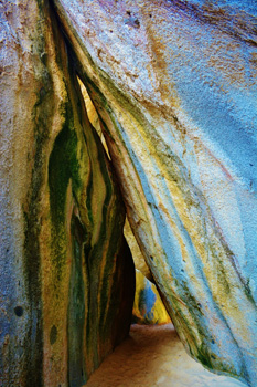
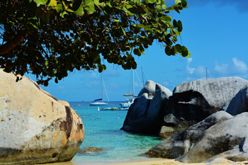
 Nothing prepares visitors as they leave the arid-like environment behind to enter a magnificent, immense wall of massive boulders- on a Caribbean beach. This enormous jumble of stone seems so completely and unexpectedly out of place from the natural geology of these islands. A series of step and rope handrails guide explorers through a unique maze of tunnels, arches and tide pools located throughout the baths. Echoes of splashing water can be heard as explorers crawl through tight spaces and descending ladders.
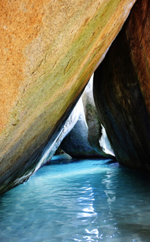 Every twist and turn yields yet another unbelievable site- hidden rooms with shafts of light streaming through, grottos which lead to more remarkable finds. The Cathedral Room, a stunning display of geological formation is the most photographed site inside the baths. Its vertical rocks form an astonishing tall, deep, triangular shaped cavern. Softly lit by ethereal rays of sunlight filtering down through small overhead gaps, this wondrous grotto is aptly named. Admiring visitors pose with a hushed reverence in its shallows as warm sea water gently rushes in and out, swirling around their legs.
The beauty and majesty of this geological wonder has not changed since war journalist Martha Gellhorn visited Virgin Gorda in 1942 as part of a Caribbean tour to assess World War II’s impact on the region. She observed that on this peaceful isle even the concept of war seemed unreal. Gellhorn described it like this in her memoir, Travels With Myself and Another. “Giant boulders arranged by geologic upheaval eons ago create a scene that is both playful and spectacularly beautiful. The sound of waves, rustle of sea grape leaves, and brush of a gentle breeze- this is the sort of place that reminds me what a gift it is to be alive”.

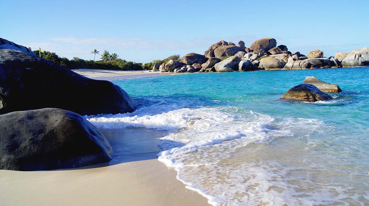
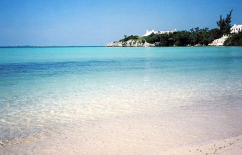
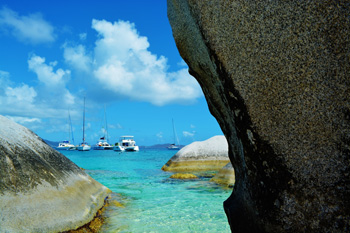 As if the spectacle of the Bath’s cavernous beauty wasn’t enough, the sinuous spelunking trail exits to a picturesque clearing with stunning views of horseshoe- shaped Devil’s Bay. Snow white talcum powdered sand is perfect for a rest from the hike under a shaded umbrella. Sailboats glide in and out of the calm bay and seabirds soar in the azure blue skies overhead. Shallow clear waters and delightful coves are perfect for a relaxing swim. Turquoise, crystalline waters of the bay teem with elusive rays, blue tang and other tropical fish, inviting snorkelers and divers to explore more underground caves and magnificent coral reefs. Boulders strewn along the beach invite hikers to climb atop for even more astonishing views of the Baths.
At the southern end of the beach, a trail leads to nearby Stoney Bay. Unlike the tranquil waters of Devil’s Bay, Stoney Bay’s windswept beaches face the crashing Atlantic swells that cast weathered driftwood along her rocky coastline.
 On our hike back to the top of Bath’s National Park, we regaled in our amazement over the incredible, magnificent natural beauty of Virgin Gorda’s fascinating Baths. Once experienced, one will forever hear the Bath’s siren call.
Our sail back to St. Thomas took us past an archipelago of inlets, cays and islands, many uninhabited. Lush green layers of mountains, miles of secluded pristine beaches beckon in the distance. A quote by famous naturalist and preservationist John Muir came to mind. “When we contemplate the whole globe as one great dewdrop, striped and dotted with continents and islands, flying through space with other stars all singing and shining together as one, the whole universe appears as an infinite storm of beauty.” And what a day filled with beauty and adventure it was!
If You Go:
British Virgin Islands Baths National Park website
Private Sunset Sail of the British Virgin Islands
About the author:
Noreen Kompanik is a freelance travel writer and photographer based in San Diego, California and a member of the International Travel Writers and Photographers Alliance. Noreen has lived in Europe and thrilled to have had the opportunity to visit 21 European countries. Noreen travels often to the Hawaiian Islands, Mexico, and the Caribbean. Her articles have appeared in History Magazine, Lost Treasure Magazine, Vacation Rental Travels Magazine, San Diego Family Magazine, Travel Mag UK, Travel Post Monthly, San Diego Reader, and In Travel Mag.
Photo credits:
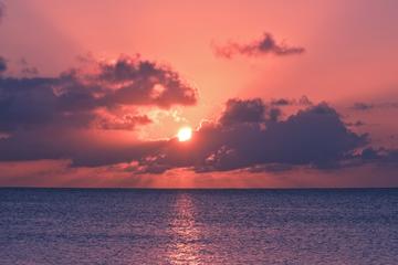
Devil’s Bay (top) by jah9teen from Pixabay
All other photos by Noreen Kompanik:
The Baths of Virgin Gorda
Weathered granite blocks forming The Baths
Approaching Virgin Gorda Yacht Harbour
Arid desert landscape leading to The Baths
“The Skull” Rock Formation
The Cathedral Room inside The Baths
Exiting The Baths to Devil’s Bay
Sailboats moored outside The Baths

 As we know, he did make landfall, but, what land was it? It was described as a ‘bean shaped island that had several small islands nearby’ Many sources assume it was San Salvador, in the Bahamas, but it’s been pointed out that this also describes Grand Turk. Right up to his death, Columbus maintained that what he’d ‘discovered’ lay off the shores of Asia, so it could be assumed his navigation techniques were suspect … and he didn’t know where he was!
 Unfortunately, His Catholic Majesty doesn’t seem to have taken much of an interest in the place, for, by 1624, the French were growing tobacco on the island and, a few years later, the Dutch had set up a colony to work the salt pans. But, in 1633, the Spanish were involved in the Eight Years War, and realised their island was in a strategic position, and asked for it back. But, the Dutch and the French were soon back, and formalised the arrangement in 1648, with the signing of the Treaty of Concordia, which divided the island up between the two nations,
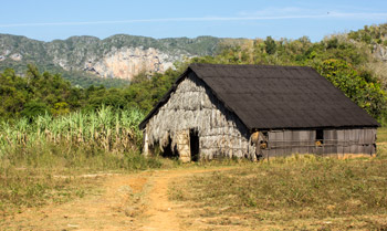

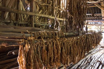
 We enter a thatched tobacco aging hut to learn about the process of growing, preparing and marketing the harvest. Each farmer is given a quota, with ninety percent of the crop being bought by the government. The farmer retains the final ten percent and is free to use it for personal consumption, local sales and exchanges or making and selling cigars to tourists. Our group gathers around our host farmer and settles in to hear firsthand about his working life.
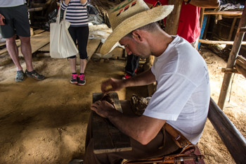 However, every farmer puts his own unique stamp on the tobacco he gets to keep, by fermenting it according to an individual recipe. These are often passed down for generations. Our guide’s family recipe was fairly simple, calling only for water, vanilla and rum. But the farm host’s recipe was a bit more elaborate, and includes “water, pineapple skin, guava leaves, honey, sugar cane and a little rum.” With a sly smile on his face, our host notes that some of that rum is applied to the outside of the leaves, and some to the inside of the farmer.
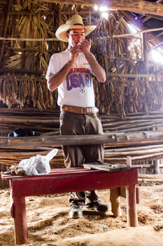 After our farmer finishes his demonstration, he lights up an aged cigar. Others are passed around for us to try, and I relish watching my fellow travelers’ reactions. I end up enjoying most of the tobacco in our Cuban Adventures group, as the others didn’t want more than a couple of puffs. Their loss was definitely my gain, for the smoke is robust and the taste smooth with a hint of honey.
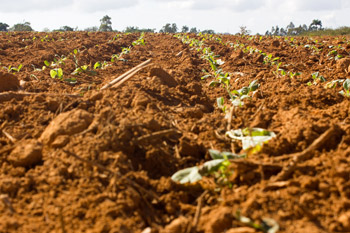
 As I let the smoke caress the inside of my mouth, I look out into the valley and into the tobacco fields below. This has been one of the essential experiences I wanted to have in Cuba and I have enjoyed every minute of it. Like our host’s recipe for fermenting tobacco, the magic came from a variety of ingredients, all blended in the right proportions: rich tobacco, fresh mountain air, a relaxed pace of life, friendly and welcoming residents and the local organic produce. The combination captured me; I didn’t want to leave Viñales, and I certainly plan to go back.
 As the plane was beginning its descent into Bermuda in the North Atlantic Ocean, I couldn’t help but notice how small the islands were, even as they were getting bigger as we were getting closer. The islands of Bermuda actually comprise one of the smallest territories in the world. Upon entering the L. F. Wade International Airport, we were greeted by a Calypso band of seven musicians that immediately got us into the tropical island mood as we prepared to pass through British customs.
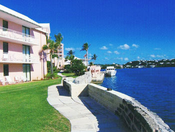 Our friend and local Bermudian, who picked us up at the airport, gave us a brief tour of the main island and explained that Bermuda is actually comprised of about 180 islands. The larger and inhabited islands are connected by bridges and causeways and some of the smaller ones or islets are actually just big rocks. The area, that measures only 21 miles in length, is only about 2.5 miles wide at its widest point.
 I truly appreciated the proximity to the boutiques and restaurants in Hamilton that were a mere 5 minute walk away.
 During our first evening, we decided leave our scooters behind at the hotel and head by taxi for dinner at the Swizzle Inn Pub and Restaurant in the small village of Bailey’s Bay. We had heard that their dishes were delicious and that it was where Bermuda’s national drink originated. The “Rum Swizzle” is a mild tasting yet powerful and delightful blend of rums, fruit juices, and syrups.
 After our dinner, we took a cab back to Hamilton and visited the many cafes, bars, and nightclubs on Front Street that are opened quite late and sometimes past 3:00 am. My particular favorite was Cafe Cairo and its exotic ambiance. Unlike what you would expect to find in Bermuda, Cafe Cairo is a popular dance club that plays music from all over the world as well as a restaurant with a Middle Eastern theme decorated in North African decor. The dining room is designed as a Bedouin tent complete with soft cushions as well as an outdoor patio that overlooks the harbor. You can enjoy a Turkish coffee, sample a Sheesha pipe, or during the busier tourist season, be entertained by a Belly Dancer!
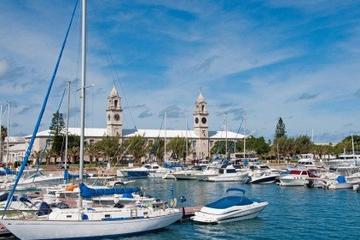

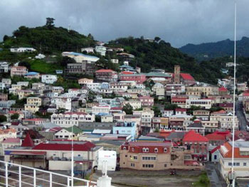 The State of Grenada is comprised of three main islands, Grenada, Carriacou, and Petit Martinique. Grenada offers friendly people, 45 white sand beaches and some of the most crystal clear water in the Caribbean. Its size is 344 square kilometers (133 sq mi), with an estimated population of 110,000. Its capital St. George’s is situated in a horseshoe shaped harbor and overlooking the capital on Richmond Hill is Fort Frederick which commands a panoramic view of St. Georges.
 The overthrow of a moderate government by a strongly pro-communist one worried U.S. President Ronald Reagan. Cuban construction workers and military personnel were building a 10,000 foot airstrip on Grenada. President Reagan was concerned that the reinforced runway was for the use of heavy military transport planes and that it would be used by Cuba under the direction of the Soviet Union as a refueling stepping stone for Cuban and Soviet airplanes loaded with weapons destined for Central American communist insurgents. On October 25, 1983 Grenada was invaded by combined forces from the United States, Jamaica and other neighboring countries in Operation Urgent Fury.
 High on a hill guarding the entrance to the harbor is Fort George. Built in 1705 it has dozens of 300 year-old cannons, tunnels, and passageways to explore and offers spectacular views of the city’s picturesque harbor. On this recent visit, we toured the island and dodged rain drops as our native guide explained how Fort George was the center of the island’s October 19, 1983 political disturbance where Maurice Bishop and part of his cabinet was executed by a faction of the People’s Revolutionary Government. He points out the plaque on the inside wall of the fort erected on October 19, 1993 with the cooperation of the Government of Grenada by the Maurice Bishop and martyrs foundation. The fort is open for sightseeing.
 Due to the worldwide recession the status of the economy is weak and there is about 30% unemployment. The agricultural industry and in particular the nutmeg industry suffered serious losses because of hurricanes Ivan and Emily that followed in 2005. However as the new nutmeg trees planted gradually mature, there is hope that the industry will return to its pre-hurricane level as a major supplier in the Western world.