by Karen S. Roberts
While looking for a quiet lakeside rental cottage for a short vacation, I stumbled upon Olcott Beach in the tiny hamlet of Olcott, NY. Not only did I find a cottage, but I discovered a quaint town with some interesting history.
 Back in the early 1900’s, Olcott Beach was a resort area. When a trolley line was put in place between the towns of Lockport and Olcott in 1900, summer visitors flocked to the beach to enjoy the cool breezes of Lake Ontario and entertainment. Also vacationers arrived by steamship. During the early years of the 1900’s, over 100,000 tourists arrived yearly.
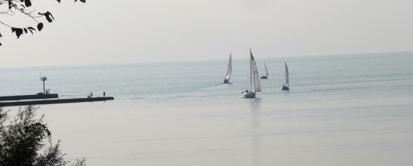
Visiting Olcott now, it’s hard to believe that it once teemed with tourists. The streets near the beach are lined with numerous summer cottages. At the Beachfront Vacation Cottages where we stayed, my husband and I enjoyed sitting on the deck each day, looking out over the beautiful lake with its sailboats, speedboats, kayakers, ducks, and sea gulls. On a nearby marina pier, several fishermen enjoyed the summer weather and each other’s company into the evening. But there were no big crowds.
Olcott Beach especially became popular when The Luna Amusement Park opened in 1898, featuring live entertainment at the Dreamland Dance Hall. As the crowds increased due to the trolley, eight hotels opened in the area to accommodate folks who came to enjoy the beach and entertainment.
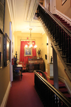
The most popular hotel was the Olcott Grand Hotel, with one hundred rooms and a huge veranda overlooking the beach. Swimmers had direct access to the water from the hotel. But the real draw for tourists was the Grand Ballroom of 14,000 square feet. It was the beginning of the Big Band era, and popular musicians performed there. These included Guy Lombardo and Louis Armstrong.
Unfortunately, due to the Great Depression when people had little money to spend, in addition to the increase in automobile ownership, the hotel business at Olcott Beach and many other Lake Ontario tourist communities floundered. People could drive to the beach for a day and return home without spending money on a hotel. In 1927 a huge fire wiped out many buildings and the amusement park along the main part of the tourist area. The Grand Hotel was repaired, but only survived a few more years. Due to deterioration, the building was demolished in 1937.

Then in 1942 there was an upswing of summer visitors, although not the hotel business. The new Olcott Amusement Park became a tourist attraction. But it closed in 1986. Another small amusement park called New Rialto was open at Olcott Beach during some of those years as well. These small parks couldn’t compete with Darien Lake Amusement Park, which is now a Six Flags park. That park is only 43 miles from Olcott and opened in the early 1980’s.
Today Olcott is still an attraction for swimming, boating, and fishing. The town now sponsors major fishing derbies which draw in folks who love to compete for trophy fish. In 2012, Olcott Beach won the title of “Ultimate Fishing Town” in an annual contest sponsored by The World Fishing Network. The deep harbor is well known as a great place to catch salmon and trout.
The area north of Main Street in Olcott is the part of town called Olcott Beach. One of the unique characteristics is what might be the tiniest boardwalk anywhere with just a few seasonal shops.
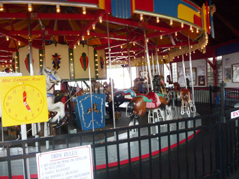 When we parked near the shops, we immediately heard the “oom-pa-pa” of a carousel’s Wurlizer Band organ. The Olcott Beach Carousel Park was developed in 2003-2004 by local volunteers who raised funds for building a vintage amusement park.. It features an old time Herschell-Spillman two-row carousel and a few other kiddie rides for only 25 cents a ride! They can do this because the park is staffed by volunteers and is incorporated as a nonprofit organization. When you enter this quaint park you feel like you are going back in time to around 1945.
The local volunteers who restored the round carousel building made sure that it resembled the original one that was built in the 1940’s. The volunteers take pride in letting children experience the fun of simple amusements like the ones enjoyed when their grandparents were children. This cute little park is open from Memorial Day Weekend through Labor Day each year.
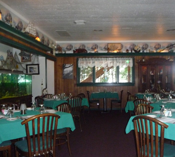 After a stroll through the mini-boardwalk and the park, we went around the corner to eat at the Mariner’s Landing restaurant. We chose to eat inside due to the heat that evening. But we could have eaten on an outdoor upper deck which offers a stunning view of Lake Ontario and nearby Krull Park. The inside was filled with nautical decor, especially on an upper ledge that ran all the way around the dining room. It was filled with models of ships, lighthouses, sea captains, and other knick-knacks. They were fascinating to look at.
Both of us ordered fish dinners. The waiter seemed a bit impatient as we asked questions about substitutions for potatoes and coleslaw, but he also was quite busy covering several tables in the dining room as well as out front on the sidewalk. Later he stopped by and in a more friendly way chatted about how to cook cabbage. We enjoyed our dinners and viewing the decor. We had to wait awhile to get our check, but overall eating there was fun.

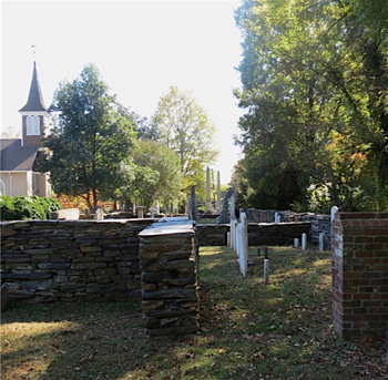
 After our meal we needed to walk off some calories and wandered across the narrow street into the beautiful 325-acre Krull Park. The park overlooks the lake in the area where the old Grand Hotel once stood. We didn’t go down the steep stone step pathway to the beach below where the swimming area is, but enjoyed the view from above. The park is pleasantly arranged with benches, picnic areas, and pavilions. We heard that over the summer several festivals take place at the park. Across Main St. is another section of the park. In a drive-by, we could see busy recreation fields and courts that were full of kids playing sports, along with spectators. A cheerleading squad was practicing within sight of the street also.
Within the park is a playground with a water spray area, as well as two ice skating rinks. This small community obviously takes pride in their park. It was very clean and nicely landscaped.
That evening we finished our day back on the deck at the cottage, hoping for a spectacular sunset over Lake Ontario. Although the sky was somewhat colorful each evening as the sun went down, we didn’t see the stunning sunsets that are often enjoyed at the lake.
I felt like we should have planned to stay a day or two longer to see other sights in the area. Olcott isn’t far from Niagara Falls and the Erie Canal that runs through Lockport. I’d like to return again next year during one of the festivals. If so, I hope to see one of those amazing sunsets!

If You Go:
♦ Olcott Beach Carousel Park
♦ Newfane and Olcott Beach Tourism Facebook Page
♦ More Info About Olcott
♦ The Buffalo News review of Mariner’s Landing
♦ History of Herschell-Spillman Carousel Making
About the author:
Karen S. Roberts, a free-lance writer and blogger, lives in Rochester, NY. You can visit her author page at amazon.com/author/karenrobertsbooks. Some of her blogs are become-a-secret-shopper.com, daily-devotionals.com, and bestgymnasticsvideos.com.
Photo credits:
It’s unusual to see four sailboats so close together on the lake – by Karen S. Roberts
It’s fun to visit these little shops that are only open during the tourist season – by Karen S. Roberts
The community takes pride in maintaining the vintage carousel – by Karen S. Roberts
Mariner’s Landing is a relaxing place to get a fish dinner in a unique nautical-themed atmosphere – by David Roberts
Krull Park, overlooking Lake Ontario – by David Roberts
 by Connie Pearson
 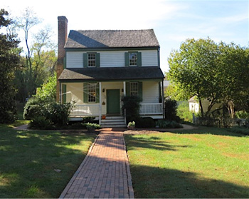 Driving into town, the first logical stop is the Dickson House at 150 E. King Street, which has Civil War significance and now serves as the Orange County Visitor Center. Park your car and see a 7-minute video giving an overview of Hillsborough’s history. Arrange for a guided tour, ask for information about restaurants, shopping, and town events, or purchase a walking tour booklet for $4.00. Make note of the public restrooms available on the grounds. The walking tour will take you past 46 well-documented structures, and 5 more are within a short drive. Most of the homes and offices are privately owned, but guided tours are available for Ayr Mount, Burwell School, and the gardens of Montrose.
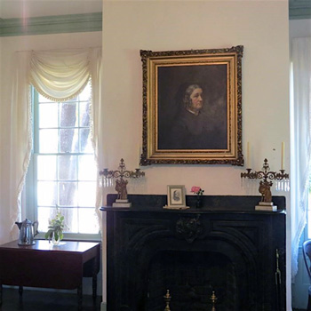 During a tour of The Burwell School Historic Site, you will hear many stories about the Burwell family, particularly wife and mother Anna Burwell. She was the very accomplished and well-educated wife of Robert, minister of Hillsborough Presbyterian Church. She did such an impressive job of educating her own 12 children, she drew the attention of a local doctor who asked her to teach his daughter as well. Anna Burwell saw that as an opportunity to supplement her husband’s meager salary. From that small beginning, she went on to oversee the educations of more than 200 young women from 1837-1857.
 A fascinating side story from those school years has ultimately drawn greater attention. A household slave girl named Elizabeth Hobbs Keckly worked strenuously for Mrs. Burwell. Although “Lizzie” had a harsh life, she eventually bought her freedom and became an accomplished dressmaker with such famous clients as Mrs. Robert E. Lee and Mrs. Abraham Lincoln. Mrs. Lincoln invited Lizzie to live in the White House and be her personal dresser. In that role she also became Mrs. Lincoln’s confidante, much of which is chronicled in Keckly’s book
 You will probably work up an appetite with all of that walking. If so, Saratoga Grill at 108 S. Churton Street, is a delicious choice. New England clam chowder, Honey Almond Salmon, and scones are specialties. Blackened scallops, salads with house-made dressings, peppered swordfish, or the broiled seafood platter are other savory options. Every dish bursts with flavor. Doors open at 11:30 a.m. Arrive about that time. It will be completely full by 12:30.
 Frances Mayes, author of Under the Tuscan Sun, recently described Hillsborough this way: “After only two years, Hillsborough seems like the home I never left. When my family and I decided to move to North Carolina after decades in San Francisco, we kept hearing from friends in this area, ‘You must move to Hillsborough — that’s where all the writers and artists live.’ Being writers ourselves, we were magnetized by the idea of a town where creativity thrives, and, having grown up in a small town in Georgia, I wanted to return to a place with an intense sense of community. By great good luck, I found both, and more.”

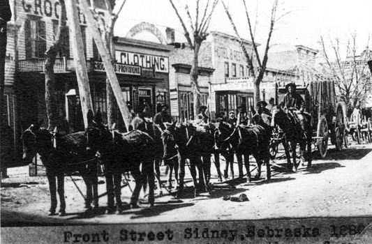
![Rose Street [now Center Ave] circa 1881](https://travelthruhistory.com/pix/nebraska2.jpg) To protect the Union Pacific Railroad and its workers from an increased frequency of Indian attacks, Fort Sidney (aka Sidney Barracks) was built in 1867 as a strategic place to safeguard interests of United States expansionism. (Fort Sidney was named after Sidney Dillon, a railroad attorney and president of the Union Pacific). By 1874, the Black Hills Gold Rush fever hit the Dakota territories, peaking in 1876-77. With gold as the lure, Sidney became the southern terminus for those traveling north to Deadwood in the late 1870s and 1880s, seeking their fortunes in the windswept Black Hills and sacred Native American territory.
To protect the Union Pacific Railroad and its workers from an increased frequency of Indian attacks, Fort Sidney (aka Sidney Barracks) was built in 1867 as a strategic place to safeguard interests of United States expansionism. (Fort Sidney was named after Sidney Dillon, a railroad attorney and president of the Union Pacific). By 1874, the Black Hills Gold Rush fever hit the Dakota territories, peaking in 1876-77. With gold as the lure, Sidney became the southern terminus for those traveling north to Deadwood in the late 1870s and 1880s, seeking their fortunes in the windswept Black Hills and sacred Native American territory.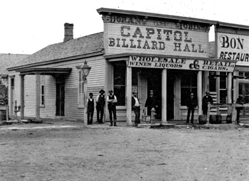 Sidney grew from a place with endless and empty Great Prairie views to a boomtown sprouting saloons and bordellos as quickly as the timber could be had. Of course, with easy money and loose women came outlaws. Sidney was no exception. From 1876-1881, the town had the notoriety of accumulating over 1,000 criminal cases along with 56 reported murders. Crooked town leaders often looked the other way on many cases that reputedly did not happen.
 Many a famous person made their way through Sidney in addition to gold miners, gunslingers, cattle rustlers, gamblers, prostitutes and God-fearing pioneers and homesteaders. The legendary likes of Wild Bill Hickok, Calamity Jane, Doc Middleton, Buffalo Bill Cody, Butch Cassidy, Jesse James, and Susan B. Anthony found their way through this frontier town.
 The beginnings of what would be a ‘hanging-gone-all-wrong’ commenced with the largest gold robbery in the history of the United States. It was the year 1880 and as might be expected, it occurred in Sidney, involving the equivalent of a $5 million gold armed getaway. The repercussions of this unsolved heist (even today it remains a mystery) were so far reaching that the Union Pacific Railroad threatened to pull up stakes if the town didn’t clean up its tumultuous reputation.
 Fearful of their livelihoods vanishing forever, a group of 64 businessmen and leading citizens were determined to change forever the future of their town. The vigilante group decided to roundup 16 of the most belligerent, badass crooks they could find within their city confines. The intention was that this unsavory group of thugs would be hung in town as an example to others of what happens when you go afoul of the law.
 On April 5, 1881, the Cheyenne Daily Leader reported, “The mob led the way over to the Courthouse square, threw a rope over the branch of a tree, and then they proceeded to draw Red up. Red did beg for his life to no avail, but the mob did consent to place a handkerchief under the noose, so as not to hurt his neck. The mob had tied Red’s hands and feet, and simply lifted him from the ground, strangling him instead of breaking his neck. It was reported that the contortions of the body are described as horrible in the extreme. Red did not die for a full fifteen minutes.”
 The story goes that after the lynching and subsequent herding up of prostitutes for shipping out on the next train, that 200 people left Sidney before the April 22, 1881 deadline as stipulated in the decree. As author Loren Avey wrote in, Lynchings, Legends, & Lawlessness – the Story of Historical Sidney, Nebraska, “The population of Sidney decreased dramatically in a very short period of time.”
 Cabela’s World Headquarters
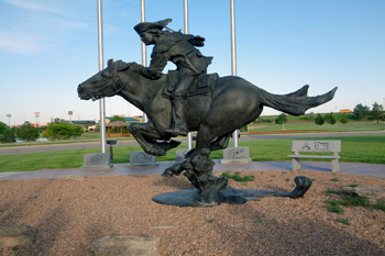 The Sidney Pony Express Monument – The bronze statue of a pony express rider and his horse is a fitting tribute to one of the most dangerous occupations in the history of the West. Nebraska had more miles of trails than any of the other seven states where the pony express riders rode. This is the only national monument with a marker and flag for every state on the Pony Express route.
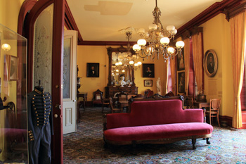
 Built in 1870 by John Morrissey, a famed boxer and member of the notorious Tammany Hall crew, the Casino was first known as the Saratoga Club House and there were three rules strictly adhered to while it was in business. No ladies, only cash transactions and no locals allowed.
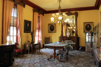 John Morrissey passed away in 1878 and the Club House fell into a state of decline until 1893. when Mr. Richard Canfield purchased it. Although he’d decided to keep the name of the Club House intact, it was the public that dubbed it ‘Canfield Casino’ and it stuck. Nearly $1 million was devoted to renovations, with a stunning grand ballroom added. This room had vaulted ceilings, colorful Tiffany stained-glass windows and over-the-top chandeliers, which added to the air of splendor Canfield was aiming for.
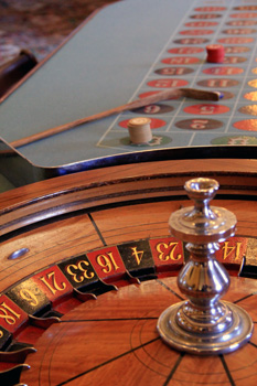 Downstairs, gamblers could begin with $1 dollar bets. Upstairs, the stakes were much higher, oftentimes as high as $100,000. Only the most elite, arriving from all over the country, walked up the long staircase to play there.
 High stakes gaming tables stand among heavy sculptures and dark wood fireplaces. Long, heavy brocade drapes hang from windows that let natural light seep in, lending an air of mystery to the parlor.
 Even the well known SyFy channel had their ‘Ghost Hunter’ cast visit the museum. Ghostly voices and paranormal activities were made known during the time that the crew was there.

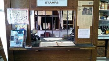 In 1881, the Postal Service installed a Post Office in the front of the store and Dalglish became Postmaster.
 In 1923, they closed the store and sealed all the windows and doors with roofing tin and lumber with all furnishings, and merchandise still inside … and so it remained until 1988.
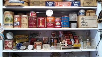 “All the furnishings and merchandise were just as they were when they closed the building in 1923, except that everything was covered with bat guano. It was about two inches deep on everything. There were thousands of bats in the building. Many were flying about as we had disturbed them, but many more still clung in clusters on every exposed ceiling joist.”
 After three more years finishing up existing projects and wondering how to do it, the Edmunds began restoring the Pioneer Store.
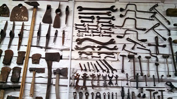 Nearly all the glass in the large front windows had been broken, and the building had acquired a decided lean to the right. They pushed the logs back into shape, rebuilt the window frames, and installed new glass.
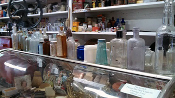
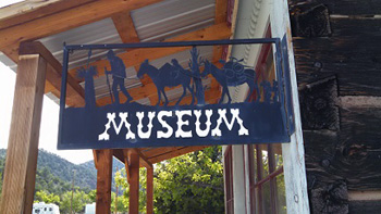 With the walls straightened up, cleaned, painted, windows replaced, and items of merchandise cleaned and refurbished, it was time to put everything back in place. As the pieces went back on the shelves, they recognized what a treasure this truly was, a real ‘old time Mercantile’ right there in Chloride.
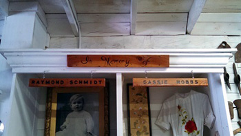 The museum is an accurate recollection of the store as it was at the turn of the 20th century, except that the tools are on walls instead of shelves and a small section has been set aside as a memorial to Cassie Hobbs and Raymond Schmidt. Cassie and Raymond were citizens of Chloride who … well, that’s another story.