Pagaso Springs, Colorado
by Karin Leperi
Albert H. Pfeiffer, a European immigrant and a comrade of Kit Carson, was a fur trapper, pioneer, soldier, and Indian agent, born in Germany on October 7, 1822. He was the son of a Lutheran minister from Friesland while his mother allegedly was a descendent of Scottish royalty. As such, young Pfeiffer was enrolled in the Military Academy of Stockholm, known for its excellence in military strategy. At the age of twenty-two, he immigrated to America, settling in St. Louis, Missouri in 1844. Seeking a more western experience, he moved on to Santa Fe, New Mexico Territory.
By the age of thirty-four, he married into an influential Mexican family from Abiquiu. It was rumored that his sweetheart and new bride Antonita, wore one of the most expensive wedding dresses for the time.
A few years later, Pfeiffer became a sub-agent when Abiquiu was a trading post. He reported to Indian agent Christopher “Kit” Carson. By all accounts, Pfeiffer maintained friendly relations with the San Juan Utes, more so than any other white man had before him. Reputedly, he was such a close friend of Chief Ouray that he was adopted by the tribe. The mutual reverence would continue throughout his life.
Then came the Civil War. Pfeiffer enlisted with the New Mexico Volunteers, serving under Colonel Kit Carson. He would eventually be promoted to 1st lieutenant, captain, and then colonel. Fighting mostly against the Indians, the two forged a friendship that would continue throughout their lives. According to Pfeiffer’s granddaughter Pauline Nielsen, “Recordings in military archives place him constantly by Carson’s side riding together from the start of his career. He was twenty years younger than Kit Carson, but history and writings tell of the close friendship that grew between the two. The relationship was a genuine one of man to man and officer to officer.”
Avenging the Heart
 Pfeiffer had a penchant for fighting in the nude, or so it would seem. His first nude encounter happened on June 20, 1863, as a forty-one year-old captain based at Fort McRae, near today’s Truth or Consequences, New Mexico. (The fort has since been flooded by Elephant Butte Reservoir). The captain had taken ill and thought the hot springs, about six miles from the fort near the Rio Grande River, would be beneficial for his malady. He bathed in the curative springs, while his pregnant wife of seven years, Antonita, his adopted daughter Maria, and her attendant Mrs. Mercardo, bathed in a pool nearby. His three-year old son Albert had been left at the fort with servants. Additionally, soldiers accompanied the group to safeguard their bathing at El Ojo del Muerto, the Spring of the Dead.
Unknown to them, about twenty Mescalero Apache lie in wait, carefully concealed by rocks, waiting for the right moment. The Apache ambushed the party, snatching Pfeiffer’s wife, daughter, and attendant. Separated from Captain Pfeiffer by the Apaches, the soldiers quickly dispersed, leaving Pfeiffer to fend for himself.
 Pfeiffer’s only thoughts were to save his wife and daughter. With his rifle lying close by, he instinctively leapt for the rifle, running to the safety of the nearby river bank, completely nude. Clothes were the least of his concern. According to the November 1933 issue of The Colorado Magazine, “He was followed by the Indians who shot at him, one of the arrows entering his back with the end coming out in front. In this condition, with the arrow in his back, he ran until he reached an enclosure of rock where he made a halt to rest and defend himself.” Later, he arrived at the fort with an embedded arrow just below his heart, more dead than alive. Still naked, Pfeiffer was barely recognizable as his sunburned skin peeled off in layers. “When the surgeon drew out the arrow from his back, the sun-scorched skin surrounding the wound came off with it, and for days the Captain suffered intense agony and lay for two months at the point of death,” according to the magazine.
Captain Pfeiffer knew the Apache well enough that they would keep the women alive as slaves. Unfortunately, when members of his party went after the women, the Apache shot their hostages as they retreated – viewing their captives as a hindrance in their game of “hide and seek.” Both Antonita and Maria died.

 Pfeiffer was so despondent over the loss of his family that he vowed to kill Apaches to avenge their death. It almost became a passion. The Colorado Chieftain newspaper on June 29, 1871, read: “It was a bad day for the Apaches when they killed old Pfeiffer’s family. He made several trips, alone, into their country, staying, sometimes for months, and always seemed pleased, for a few days, on his return. He was always accompanied by about half a dozen wolves in the Apache country. ‘They like me,’ he said once, ‘because they’re fond of dead Indian, and I feed them well.'”
He had no love lost for the Navajo either, having battled hem victoriously in Canyon de Chelley, six months after becoming a widower. He was promoted to Lieutenant Colonel by brevet because of his bravery against the Navajo. To Pfeiffer, the Navajo and Apache were life-long enemies who he relentlessly pursued to his death. On the other hand, the Utes were like family to him.
David vs. Goliath Indian Style
 The Utes and the Navajos both revered the healing powers of the hot springs, located at modern-day Pagosa Springs, in southwestern, Colorado. The Utes had laid claim to the land generations prior to the Navajo challenge, but shared the springs because of their sacred origins. Then, in late 1866, the Navajo challenged the Utes for control of the springs, fighting for several days to stake their claim. Unfortunately, it ended in a stalemate.
Colonel Pfeiffer suggested the dispute be brokered by having each Indian nation contribute one warrior to the fight – a fight to the death for ownership of the springs. Legend has it that the aging Colonel Pfeiffer volunteered to represent the Utes (or maybe they chose him), insisting it be fought only with Bowie knives and in the nude so no other weapons could be concealed. Other accounts suggest they were nude from the waist up only.
The Navajos chose one of the largest, and youngest yet seasoned warriors. Colonel Pfeiffer, by comparison, was rather short. A rather peculiar match as Pfeiffer was a mild-mannered, blue-eyed, bald-headed European – about 5’5″ in stature. However, what Pfeiffer had going for him was that he was known as a rather good Indian fighter with a plethora of battle scars and gunshot wounds to prove it.
The story goes that once the Navajo giant saw all the battle scars on the naked Pfeiffer, he became afraid and was easily defeated. The outcome was that the Utes retained possession of their sacred hot springs.
If You Go:
The Visit Pagosa Springs, Colorado website

Dog Powered Scooter Jor-ing in Pagosa Springs
About the author:
Karin Leperi is a multi award-winning writer and photographer with bylines in over 90 outlets that include print, radio, internet, and mobile media platforms. Her 1,500 plus articles cover topics ranging from culture, cuisine, luxury and lifestyle to aviation, photography, history, and nature.

All photos are by Karin Leperi and Jennifer Green:
Knife Duel Memorial
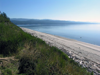
Pagosa Springs
Pagosa Springs Today
Colonel Pfeiffer Gravesite
Pfeiffer Homestead Marker
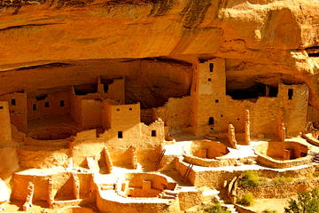
 Evidence of settlement on the Colorado Plateau only dates back to AD 550, but signs of human presence on the plateau go back at least 10,000 years to the Paleolithic Age. For much of the known history of these people, they existed as tribes of wandering hunter gathers. Forging for food is easier than farming.
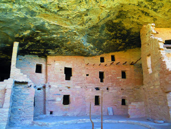 The Anasazi are rich in history. What is emerging is from the archeology work is a complex and, somewhat egalitarian, society. They succeeded to thrive for millennium in a sparse land with harsh winters. The archeological evidence of the Anasazi date back to 1200 BC—a time known as the “Basket Making Era” since they had baskets, but no pottery, and lived in camps or caves, surviving off a staple of cultivated squash and corn.
 If you’re coming from Denver, you’ll enjoy the scenic, mountain-carved route along US Highway 160W and US 285S. I drove in from Grand Junction, along US 50. If you can do this drive in the fall, roll your windows down and you can smell the yellow and red leaves bursting in bright patches amongst ever-steady green pines. Carved cliffs of rock will add earthy tones to the pallet, and blue sky might cause you to turn the radio down so as to let the evolving panoramic fill your senses.
 In San Ángel, the two artists fed, and bled, off each other. Medical problems plagued Frida, and her third pregnancy ended in yet another abortion. Diego had affairs, including one with Frida’s own sister, Cristina, resulting in a temporary separation. But Frida’s artistic and intellectual power also grew during this time, not only thanks to her husband, but also to the circle they drew around them. There, the surrealist André Breton recognized Frida’s talent and offered to show her work in Paris. Not long after, she gave her first solo exhibition at Julien Levy’s gallery in New York City. The San Ángel house was an incubator for both Frida’s talent and her misery. The two went hand in hand, as she painted portrait after portrait of herself in the form of an invalid and scorned woman, sad and withering away just as her star began to grow. Yet, through all this, Frida was slowly, but surely, becoming recognized for something more than her marriage to Diego Rivera. She was an artist in her own right, standing on her own two, albeit crippled, feet.
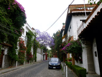
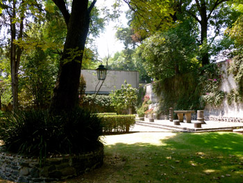 While Plaza San Jacinto is the neighborhood’s most popular outdoor space, the neighboring church (of the same name) provides a much more beautiful and calm place in which to rest. The Iglesia de San Jacinto was built in the 16th century, and feels almost lost in time. Both the building and its garden predate the Great Fire of London, with an architecture and sensibility that might be more at home in Italy, or France, than Mexico. The cloister feels Tuscan, the sanctuary Spanish. The garden is wonderfully wild, almost English in style, hidden behind large stone walls, yet easily accessible through both the church and a stone archway. It’s one of the most serene places in Mexico City, a beautiful spot to rest and contemplate, and begin to understand how truly ancient this country is, even in its colonial manifestations.
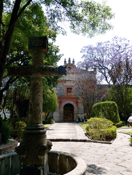 Frida’s painting, The Two Fridas, tackles that very same subject, and dates from the years in which she lived in San Ángel. In the double self-portrait, a European Frida holds the hand of an indigenous Mexican version of herself. Even more importantly, their bloodstreams are connected by an artery flowing from heart to heart, bleeding out one end. In many ways, The Two Fridas is about acceptance – of Kahlo’s ancestry, and of Mexico’s—though it’s also about struggle, both in her understanding of her own personal identity, and of her marriage. It’s no accident that Frida needs to hold her own hand in the picture. The Two Fridas was painted just as her marriage was falling apart, and she divorced Diego for the first time.
 Despite the tragedy that surrounded their relationship, Frida’s San Ángel house is not an inherently sad place to visit. It’s architecturally interesting, and provides a hands-on, visceral glimpse into the two artists’ lives—a chance to see the furniture, books and giant papier maché dolls that filled Diego’s studio, and the ghosts that are left behind in Frida’s. Outside, tall cactuses grow like relics of a great pre-Columbian past, and purple Jacaranda trees frame Frida’s part of the building, which like her house in Coyoacán is painted a deep, vibrant blue. For all the pain and hardship she endured there, her resilience shines through.
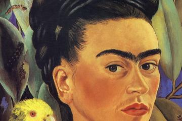


 Our journey to the isle, first recorded as Savary’s Island by Capt. George Vancouver in 1792, began at the ferry dock in Comox, Vancouver Island. An hour twenty later we were rolling off the Queen of Burnaby into Powell River back dropped by the serrated teeth of the majestic coastal mountain range. A half hour north landed us in Lund, a village dating from the 1880s when the two Thulin brothers from Sweden set up shop and named the community after one back home. Free parking is at a premium here but paid parking is available for daily fee of $7.00 at Dave’s parking lot. Savary emerged, a rich green line across the horizon, as we strolled the village boardwalk. Then we were off to our evening abode; a bed and breakfast south of Powell River.
 Stretched along the south shore, where we came ashore, were a line of substantial homes bordering the dirt road which we learned ran the length of the island, about 7.5 kilometres (.8 to 1.5 kilometres wide). Vehicles crowded a haphazard parking lot though few were to be found trundling along the low maintenance dirt roadways with the waning of summer. Admiring homes we walked as far south as the road allowed, drinking in views of beach and mountain. Perhaps appearing a tad bemused as we poured over a brochure we were rescued by a local resident who filled us in on the what’s and wherefore’s of Savary. She and her husband were just closing up their home for the season as were many of the locals; however there are a solid few who call Savary home full time and garner the fruits of civilized solitude in this stunning setting.
 She told us of the Savary Island B & B; a single floor sprawling log building we had just passed and admired. There had been a couple hotels on the island – The Savary, built in 1914 survived until it burned down in 1932 and the Royal Savary Hotel at Indian Point which was demolished in 1982. Now B & Bs, cabin rentals and a lodge offer accommodation options. The listed permanent population of 100 balloons to a couple thousand in the summer.
 A black dot on the water proved a large curious seal. Masked Killdeer complained as they wheeled about behind us and, usually solitary, Loons swam about in a group. We wore no watches. Time took on its own rhythm. Afterwards we sat on a log gazing towards the sea and enjoyed a snack. Never ceases to amaze me how food tastes better in such settings.
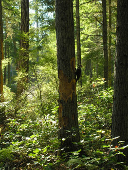 Striking out for the north beach and Mermaid Rock we returned to the dirt road, gloriously titled Vancouver Boulevard, running the spine of the island, and climbed to the height of land which was to take us through a protected and treed sand dunes section, devoid of development due to its fragility. Few cars and people frequented the roadway which felt much like a shady park walk.The takity takity tack of a noisy Piliated woodpecker echoed through the still forest; proving so intent on attacking his tree he took no notice of us. The protected zone is home to 10,000 year old sand dunes. The island is eroding steadily at both the north and south ends.

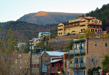
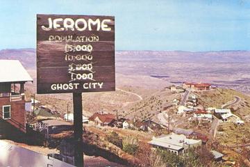
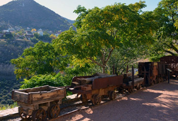 Jerome’s fascinating history began in the 1880s with the arrival of people from many parts of the globe to work the lucrative copper mines that brought its investors billions in profit. In its copper mining heyday, the population of Jerome swelled to over 15,000 and by the 1920s it hailed as the fourth largest territory in the state. Diversions for the miners’ long work hours were many and in the boisterous spirit of the West, lawlessness reigned. A New York newspaper dubbed Jerome “the wickedest city in the West.” The town boasted numerous saloons, Chinese restaurants and laundries and during Jerome’s more decadent times, brothels and bordellos.
 Just as Jerome precariously clings to Cleopatra Hill, the town desperately clung to life. It has survived, despite a long history of tragedy. Fire destroyed large sections of the town on three separate occasions, but Jerome always rebuilt. Devastating landslides and land shifts caused by hundreds of miles of unstable, honeycombed mine shafts under the city itself wrought more damage. An underground blast in 1938 rocked the town’s center, toppling the business district down the mountainside, including the city jail, which slipped 225 feet. Ghostly remains of these structures can still be seen today, some, a hundred yards or more from their original foundations. Untold human tragedies in the form of mining accidents, gunfights, opium overdoses and the flu epidemic killed hundreds. Yet Jerome stubbornly continues to survive.
 Over time, the population dwindled to a mere fifty residents and became a virtual ghost town. It was the Jerome Historical Society in the 1960s who saved the town from extinction through its preservation efforts and its proclamation that Jerome was America’s newest and largest ghost city.
 In the 1970s small groups of free- spirited artists arrived, restoring abandoned buildings and transforming parts of this ghost town into an arts community. Today, the thriving town with a population of almost 500 is home to quaint bed and breakfasts, restaurants, saloons, art galleries and unique, whimsical boutiques with colorful names evocative of the town’s history, such as Nellie Bly, Ghost City Inn and The Asylum Restaurant. Most of these businesses are located in buildings that date back to the 1800’s, forging an unforgettable link to the town’s storied past. No trip to Jerome is complete without a visit to the Douglas Mansion, home of the Jerome Historic State Park. The interesting exhibits in this stately home bring to life Jerome’s mining heritage and offer a unique glimpse of its glory years.
 At almost a 5,400 feet elevation, Jerome Winery provides astounding views of the Verde Valley that go on forever. Visitors of today wonder if the town’s residents of the past were as awed by its striking vistas. But it is ultimately the sloped buildings perched precariously on the hillsides, dramatic switchback cobblestone streets, and abandoned ruins that the story of Jerome is told. It doesn’t take much to imagine miners walking the streets, hear the tinkling of a piano or the loud, raucous laughter emerging from the saloon and the occasional sounds of gunshots.